
| Location: Rainbow
Lake, Mt Zirkel Wilderness, Routt National Forest, North Central Colorado,
near Walden.
Maps: National Geographic Trails Illustrated 1:41,000-scale Clark/Buffalo Pass (117) or USGS 1:24,000-scale Pitchpine Mt and Mt Ethel. Access: From downtown Walden, CO, head south CO 125 and turn right (west) on 12W just as CO 125 makes a 90-degree south turn. From there, head west 5 miles to the junction with 18, and veer left on 18. Come to another intersection in 4 miles, and turn left on 5. In about 1.5 miles, stay on the main road as it becomes 22, with 5 running off to the south as a lesser road. Follow 22 through the Lone Pine Ranch and past some homes all the way to the Trailhead. In all, about 15 miles and 30 minutes from Walden. Passenger car is fine all the way. Trail: Rainbow Lake is about 3.5 miles, Slide Lake 5 miles. Trailhead elevation = 8700'; Rainbow Lake = 9800'; Slide Lake = 10,500'. Trail is very well marked, and smooth most of the way with only a couple of minor stream crossings. Moderately difficult. Dog Regulations: Voice control. Horse suitability: Fine for horses all the way up to the Continental Divide. Parking lot is big enough for small trailers, but not much maneuvering room. I've seen horses on the trail almost every time I've been there. Webcam: Steamboat Springs, 15 miles to the southwest Weather: Zirkel NOAA weather station with snow depth National Weather Service Point Forecast
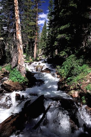
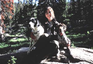
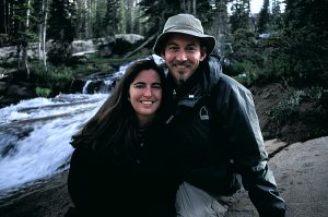
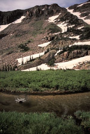
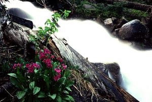
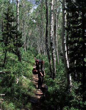
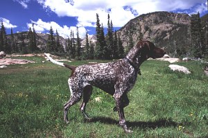
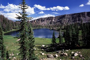
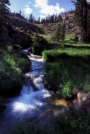
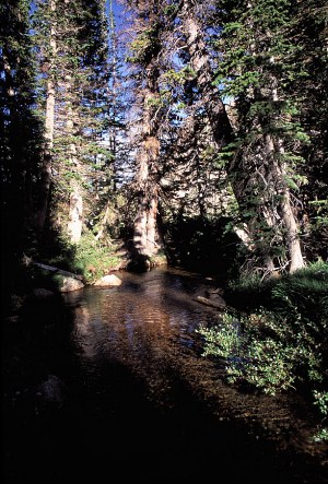
July 3-5, 2004 One can get fairly lost in Mt Zirkel Wilderness, even along the trails. It's a big place far removed from urban areas, so naturally it's one of my favorite places. It's distance from the Front Range means that even after publicizing it, I have no fear of Zirkel being overrun with hikers because most hikers won't drive this far. Fine by me. The sign at the Rainbow Lake trailhead proclaimed Rainbow Lake to be the busiest place in the entire wilderness, and I can now see why: Fantastic views of the continental divide as well as one of the largest alpine lakes in Colorado, in addition to myriad streams and waterfalls. My backpacking buddies for this trip were Andra (Home sapiens) Frank and Makenzie (Canus familiarus). After taking a few wrong turns in the maze of dirt roads southwest of Walden, I finally found the trailhead we had been seeking at the base of the mountains. We started up the trail from the east side of the wilderness around noon under a partly cloudy sky. Rain definitely threatened. I know the mischievous look of the summer cumulonimbus cloud .light and fluffy in the morning, turning to raging tyrant by 4:00. I kept my eye on them as we hiked up a gorgeous stretch through a very large aspen grove. Palpable humidity increase greeted us within the airy leaves and white trunks of the aspen, as well as sweet scents that we were never quite able to pinpoint. Frank and Makenzie trotted slightly ahead of us, itching to run pell-mell up the trail, but held back by our occasional Easy commands. Within 2 miles, they had settled down a bit and were walking comfortably alongside, panting frantically. It was warm, and we were actually happy to exit the aspen grove and enter the dominating shade of the conifer canopy beyond. The trail led matter-of-factly up a gentle slope towards the continental divide to the west. Rainbow Lake lies allegedly 3.5 miles from the parking patch, although it seemed like less to us at the time. We passed a group of three friendly women backpacking up, but otherwise saw nobody. We walked along the south side of the lake, through thick spruce-fir with heavy carpets of moss and liverworts lining the dozens of little streams that cascaded down the mountain towards the lake. It was quiet and peaceful and cool. I enjoyed this area very much. Water from a major stream feeds Rainbow Lake from the west, and crossing this area allowed us to enjoy the magnificent white water frenzy of the outpouring from lakes and snow above. Logs thirty feet long jammed the torrent, and very little clear water could be seen. The spray from the crashing liquid cooled our faces. Frank, Andra and I successfully made it across the stream over a log without incident, but poor clumsy Makenzie fell in and blocked the way for the rest of us while she attempted in futile clumsiness to get back up on the log. So pathetic. Lucky her coat dries quick. I stopped at a second stream crossing to set up for a long-exposure of a beautiful waterfall. I had framed a clear pool of water with a sluice of liquid plunging into it from rocks above, and a pink flower blooming on the moss-covered stones in the foreground, and had just adjusted the timer setting when Makenzie plunged into the pool with a giant splash of water. Cold snowmelt sprayed all over me and my camera. To make matters worse, she decided to exit the water right next to me, splashing and sloshing water as she shook her coat dry. Obliviously, she trotted off to go see what Andra and Frank were up to. I spent several minutes drying my camera, and I call that spot Makenzie Falls. The trail became steep beyond the lake, and followed the crashing stream towards Slide Lake. Our goal had been to camp somewhere between the two lakes, and we were in the area of interest when it began to sprinkle. We left the trail and hiked a couple of hundred yards into the trees and found a low spot among some giant, dying spruces. In the light rain, we set up the tent and threw our gear under the vestibule. By the time that was done, it was no longer raining. Nevertheless we had scored a choice spot. The tent was tucked nicely out of view by surrounding rocks and trees, and the trail was far away. We took a walk along the same crashing stream downhill, admiring its many forms and facets. Water is imminently interesting. Makenzie entertained herself in camp by chasing rocks that we tossed into the shrubs, and Frank basked in the evening sunlight on the rocks while we cooked dinner. A backcountry ranger named Hank walked into camp, surprising us since we felt so hidden, and made sure we were camped far enough from the water. Frank greeted him with a wagging tail even before he finished asking if the dogs were friendly. Makenzie gave him a curt woof and continued playing the rock-chasing game. We talked about dinner menu items and he recommended getting freeze-dried refried beans, tortillas and cheddar for a good backcountry meal. I tried that on the next trip and it was indeed delicious, so, thanks Hank. For this trip, however, I continued to heat up water for ramen noodles, and thats what we ate. Andra felt tired near 8, and went to bed with dogs, while I hiked all around with camera, looking for the perfect angle to capture the beauty of the falls in the stream. I found during this foray that the forest rangers were camped not but 200 yards from us. No wonder they had walked right through camp. The next morning I was awakened at
5AM by woodpeckers in the dead spruce trees around the tent. Loud and shrill,
their calls were hard to sleep with, so I got up and went for a walk with
the dogs around the area. It was then that I noticed that almost all the
spruce trees were dead, only the firs lived. It was after the trip that
I learned that the Routt Divide blowdown of 1997 had created a perfect
breeding site for a native bark beetle, which has emerged in great numbers
from the blowdown area to attack nearby healthy spruce stands. I believe
this explains why so many of the spruce in this area were dead or dying.
It was a pity to see such giant trees turned to skeletons, but it also
gave the small firs ample opportunity to grow up in newly-opened patches
of forest. I found a web report on this that you might want to look at
: http://www.fs.fed.us/r2/fhm/reports/be_r2-00-05.pdf.
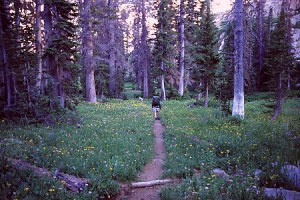
We spent the afternoon and evening walking around the area, hopping streams, taking photographs and eating dinner. It was a nice place. It rained for two hours in the late afternoon, causing us to spend time in the tent, reading and napping. Luckily, I had a good book with me so I didnt mind. The next morning was clear and warm, and we took another walk around the area before having oatmeal for breakfast. While I cleaned dishes, Andra packed and by 10 we were on the trail, heading down. We stopped at Rainbow Lake, which seemed largely deserted, and took a break. The wind was streaking out of the west, creating whitecap waves on the water. Andra chickened out on wading since it was so cold. I had never comitted myself to wading so technically there was no chickening-out on my part. We hiked on down the trail, arriving at the car around 1:00. A quick dash to the quicky-mart in Walden satisfied our post-hiking junk-food urges with soda, chips and chocolate. The clouds were building as we drove off, and before home we were rained on many times.
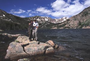
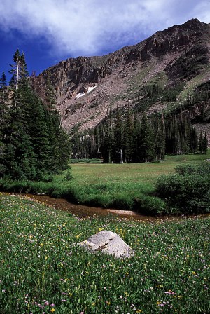
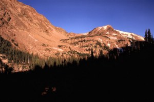
August 7-8, 2004 Roughly a month later, we again parked at the same dirt patch by the Rainbow lake trailhead (same parking spot, in fact), and shouldered our packs for the walk up to the lakes above. The weather was more stable this time around, and we expected no rain from the cloudless blue skies overhead. It also seemed to be much warmer this time around, and we sweated accordingly as we labored up the first stretch of trail. At Rainbow Lake, the large snowfields that ringed the eastern shore a month prior were gone. We stopped here to relax in the warm sunshine and play with the dogs, who were itching for more physical action than walking next to us at a measly 2 miles per hour. We threw sticks into the water for the dogs to fetch, and when that got old, rocks into the meadow for them to chase. We continued on up the trail, passing all the familiar places, only with unfamiliar flowers in place of the early summer varieties. Where early blooming buttercups had brightened the meadows in early July, there were now tall daisies in purple, yellow and white. We passed by Makenzie Falls, crossed the creeks where again she fell off the log and into the water, and followed the steep trail alongside the trail that leads steeply west from the shores of Rainbow Lake. I had noted where we had last camped on the map, and the best way to get there. Thus, it was with very little trouble that we returned to the same spot we had set up our tent at a month before. Again, we set up the small tent and stowed our gear. Since we had not made it up very much further on the trail on our previous attempt, we decided to immediately set out on the trail and see how far we could go with plenty of light. On the trail, we passed familiar places, which makes it much more fun, and then entered new territory. I didnt look at the map much, but it turns out we passed by Slide Lake and came out next to Upper Slide Lake, a smaller body of water uphill from its big brother. I wanted to continue on the trail, but Andra did not. We decided to part ways for a bit. Frank and I went on ahead while she and Makenzie stayed by the lake shore. Makenzie ran after me on the trail once, then ran back halfway to Andra, ran back to me, then finally ran all the way back down the trail to Andra. You could see the confusion in her little canine eyes. Frank was all about going on up the trail, so I had to work to keep up with him. This section of the trail is the steepest on the whole route, and I was well spent when I topped out on a beautiful rockscape of cushion plants, boulders and shallow tarns reflecting the sky. I thought I might make it to the Continental Divide, but I reached a point where I could see the trail sink down into another valley before it crested at the divide and I decided to abandon my plan to reach it. On the way down, I deviated from the trail route to get a good look at the lake below by which Andra and Makenzie were waiting. I found a nice rock outcropping from which to view the lake, from where I was about 500 feet above the lake. I couldnt see Andra, but I could see several tents set up around the lake. Frank and I made our way down without the trail, and then found Makenzie and Andra. We sat for a little while by the lakeshore in the afternoon sun before heading down. In the middle of the grassy meadow by the lakeshore, Andra fell headlong onto her chest after tripping on thin air. I was lucky to witness the event as I had just turned around to talk to her when I saw her flying forward. We checked, but could find nothing except smooth dirt trail that she might have tripped on. Graceful hiking 101. We walked off the trail on the way down to follow a creek that had incredible wildflowers along it. It was hard to photograph since the sun was backlighting everything, but still it was fun. We got to camp close to dark and cooked dinner of burritos as the wilderness ranger Hank had suggested. Fantastic! Then to bed. The next morning I woke up before dawn and crept away in the dim half-light of morning to a spot I had found the evening before. I set up my camera on the large rock slant to point west towards the rocky face of the continental divide. Then I waited for sunrise. Even in August, alpine mornings are very cold. I watched my breath puff out like smoke, and squeezed my gloved hands under my armpits to keep them warm. Expectedly the sun rose. First, a pale orange glow rose from the rocks to the west, then a definite shadow was cast near their base as the mountain peaks were bathed in an increasingly intense orange light. I snapped away, and the sun rose quickly higher. The second-by-second change in the look of sunlight is never so obvious as at dawn. Most people could not tell 11AM from 12AM, but you can certainly tell 1 minute after surnise with 5 minutes after sunrise. I watched the light creep down the wall of rock before me, enjoying the calm but dramatic change. In 30 minutes, the light had grown completely white, and the shadows had slowed their movement. I packed up my kit and headed back to camp, snapping flower photos along the way. When I got to the tent, I was informed that Andra would never be watching the dogs while I left in the morning again. Apparently, they had not been very quiet and serene while I was away, and had consequently kept Andra from enjoying a rare sleep-in opportunity. I took the dogs and played fetch with them while Andra slumbered in the morning cool. In an hour she was ready to get up and I happened to be nearby so we made breakfast and hit the trail. We slowly made our way up the trail, then branched off to the south into a flowery meadow. We hopped the creek and made our way towards the steep rock walls that contained the valley. We stopped at a small creek and Andra waded. She only waded for a few seconds, citing the extreme cold. My feet dont take even mild cold so I kept my shoes on the entire time. Upstream, she found the largest patch of moss either of us have ever seen. In the other direction, we found a beautiful waterfall that fed a large wet meadow of daisies. In all, we spent about 4 hours slowly touring the area. With that, it was relatively late in the day by the time we packed up camp and hit the trail. |
 |
 |


|