Location:
Upheaval Dome in the Island in the Sky District
Directions:
From
Moab, UT, drive 10 miles north on Highway 191. Go west on UT 313 for 30
miles into Canyonlands National Park and follow signs to Upheaval Dome.
Trail: 36
mile loop starting at Alcove Canyon, to the Green River via Taylor Canyon,
up Upheaval Canyon to Upheaval Dome, then south around Upheaval Dome back
to Alcove Canyon TH. Hike can be done in reverse without any trouble. Very
well marked, mostly flat, but very steep in a few places. No water in Taylor
Canyon so bring lots on your own. Green River water is hard to filter!
Water is sometimes available in side channels of Trail Canyon and in Syncline
Valley..ask a ranger before starting out.
Maps:
USGS 1:24,000 Upheaval Dome
& Horsethief Canyon;
Trails Illustrated 1:62,500 Canyonlands National Park Needles & Island
in the Sky (210)
Fees:
Park entrance fee ($10) & backpacking fee ($15)
Dogs:
No dogs allowed on trails, usually too hot to leave them in cars (Don't
bring dogs)
April 13, 2006
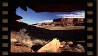
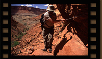
A bit of a misnomer, calling it the
Alcove Spring Trail, I think, as Larry and I laboriously make our way down
the steep descent amidst sharp boulders and loose tallus on the trail.
The drainage is painfully dry, such that only ghosts of plants poke up
through the rocks. A few hardy junipers, with roots stretching nearly down
to the molten core of the earth, are all that green the rocky slope dropping
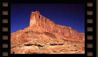
away from the massive 200-ft alcove carved from a Wingate Sandstone cliff
on the east face of Buck Mesa. We hitched the belt straps of our
packs on around 1:00 and left the truck far above on black pavement in
this, the Island in the Sky District of Canyonlands National Park. After
an unforgivable hiatus of 7 years, Ive returned to this wonderful, desolate
spot of bare earth crust in eastern Utah for another round of desert hiking.
The vagabond returns, always. The sun is out, it is warm, almost hot, and
the sweat beads up in a sheen on my face before being spirited away in
the dry air. I can feel the grit of salt on my skin already, and imagine
little white specks coating my eyelids. It is April, and a fine month to
be in the desert. While the mountains still languish under feet of snow,
the desert is greening, some plants are even blooming, and we are enjoying
a welcome break from the work which rules our lives, by escaping to the
non-electric, non-preservative, non-political desert. The air is blissfully
quiet, such silence one seldom enjoys. Each step brings a crunch of gravel
or a crackle of a dislodged rock echoing along the steep wall. For a short
while we are in the shade of the Alcove, and enjoy it while it lasts. Soon
the trail leads back out into the open sun, with no shade. The Alcove watches
over us as we leave it, uncaring. The descent is very steep, and my calves
are soon quivering from exertion. The trail switchbacks again and again
down the wash leading out from the Alcove, down through the geologic layers
to the final depth of Trail Canyon. Seen from above it looks like no more
than a crack in the orange crust. Even from here, I can see it is dry.
After an hour of hiking, the trail flattens out near the bottom of Trail
Canyon. I get ahead of Larry and am alone with my thoughts, plodding along
the sandy trail that runs north, paralleling the dry streambed. Short shadscale
saltbush crouch stoically under the desert sun. Widely-scattered bunches
of Indian ricegrass are greening up. A few purple-flowered Astragalus dot
the expanse. A claret cup cactus steals the show with crimson blooms. And
of course everywhere, the bare earth is exposed in wide expanses, often
covered with the corrugated black knobs of cryptobiotic crust. The trail
crosses several shallow washes that cut down from Buck Mesa to the west,
the mesa we just descended from. One wash is muddy, with millimeter-deep
pools of water, but everything is coated in a crust of salt. There is no
question of attempting to filter water here. Other washes are dry. After
another hour of hiking, the trail enters the dry streambed of Trail Canyon,
which is soft sand and small gravel, bordered on both sides by a lip of
rock 2-5 feet high. Walking in the soft sand is difficult, and the going
is slow and hot. I note faint traces of footprints in the sand, but they
are very faint, and are either weeks old, or strong wind has covered them
over recently. The air is yet still and the sun is shining unimpeded on
our heads and backs. I continue to slurp water, warding off dehydration.
We walk side by side down the wide wash, talking of many things: plants,
hikes, cars, women, sometimes even work (ah, it poisons everything!). I
note with slight alarm that the steep hike down from the Alcove has created
a blister between toes 1&2. Thats a new spot. I keep track of our
progress on a paper topo map sealed in a Ziploc, and stop in the shade
of the last side canyon before Taylor canyon where the park ranger said
there might be water. From where I sit, it looks painfully dry. Larry and
I discuss our options, and decide to hike up the side canyon to see what
it holds. We do, and are rewarded with clean, clear pools of water about
150 yards up the draw. We filter water, filling all canteens, and return
to our packs and out. I have 6 quarts of water in my pack, and they must
last the rest of today, tonight and most of tomorrow as we hike 6 miles
to the Green River.
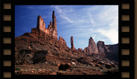
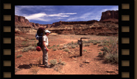
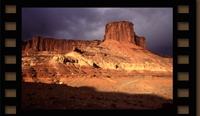
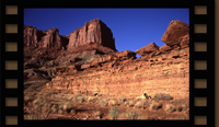
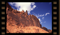
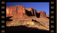
Continuing north, we see the tips of
the rock formations Moses and Zeus, and know we are close to the confluence
of Trail and Taylor Canyons. The afternoon sun slants in from the west,
casting a garish yellow tint over everything. The land looks parched and
unforgiving. We consult the map and determine to hike up Taylor Canyon
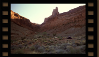
a short ways and make camp. As we turn north up the wide, sandy bottom
of Taylor Canyon, I see two trucks parked ½ mile down canyon at
the designated vehicle campsite. Until yesterday, I had assumed Taylor
Camp was a backcountry site, but in fact there is a dirt road that one
can drive up from the White Rim Road. Thus, we continued up canyon to camp,
in the Park Service vernacular, "at-large". I explore a couple of draws
that run uphill from Taylor Canyon, but each one elevates into a wide expanse
of broken rock and cryptobiotic soil with a few shadscale for decoration.
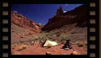
"At-large" ends up being a sandy patch just above the bottom of the wash
next to a sickly tamarisk that yields almost no shade, but more than absolutely
no shade. Larry sets his tent up in a similar scenario 50 feet downstream.
It has taken us 5 hours to hike 6 miles, and I sit in the semi-shade by
my tent and ponder where the time went. We hiked pretty darn slow coming
down from the Alcove, it being so steep, and we stopped for a long break
to filter water. Still, somewhere it nags at me that weve lost time somewhere
along the way. Ive brought my single-man tent, the kind that looks like
a sausage. Its held up by two short semi-hoops on either end, then stretched
lengthwise by 4 stakes to hold it up. In the soft, deep sand, the stakes
do not find much purchase, and the tent leans inward. A thin yellow rainfly
covers it, mostly. Russian thistle and rabbitbrush provide the chief topographical
distractions in the vicinity, aside from the 8-foot tall tamarisk. I note
the base of the tamarisk is pocked with half a dozen rodent holes, and
make a mental note to zip up all pockets on my pack and hang my food tonight.
Larry brings his camp stool over, along with his home-made elk jerky. We
sit in the sand and I sample both kinds he has brought, and prefer the
"inferno" spice blend to the ordinary "mesquite" flavor. Drowsiness sets
in, and I decide to nap. I slide into the tent and strip down to my skivvies
(it is quite hot) and instantly fall off to sleep. After some unknown period
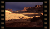
of blissful snooze time, I wake up and see the sun has sunk low on the
horizon, and a brilliant orange light is streaming in from the west. The
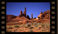
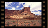
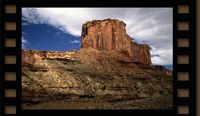
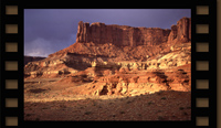
giant rock pinnacles of Moses and Zeus, just north of my tent, are bathed
in the golden light. I dress, hop out and carry my camera with me as I
ascend a wash to the south and get up into the uplands. From there I snap
several nice shots of the rocks. As I watch, the sun sinks lower, and the
rocks glow brighter red than ever imagined. The evening light seems like
a magic spell that uncovers some hidden flavor in the rock, only for a
few moments. I mosey back to camp and wake Larry up from his nap. As dark
descends, we attempt dinner. Delay comes in the form of a dry rubber plunger
that must be oiled and kneaded for some minutes before it will affect a
seal and pressurize the MSR fuel bottle. Dinner stretches beyond 8:00 and
it grows dark enough to need a flashlight. We each eat one bean & cheese
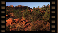
burrito, and then clean up. Around 9, the moon rises, brightly, nearly-full.
It casts a baleful silver sheen over everything, and suddenly the flashlight
is irrelevant. The air has cooled considerably, and it seems like it will
be a nice evening for sleep. I lumber to my tent, undress, and scribble
notes of the days activities before falling asleep around 10.
April 14
A cool, white light streams through
the thin tent fabric in the quiet of the morning. I dress, and spill out
of the tent, stretching off a night of less-than-restful slumber. A thin
veil of clouds hovers on the eastern horizon, filtering the sun that is
just above the rock rim of Taylor Canyon. In the still air, tiny gnats
begin to bite my arms and face. I take a stroll up the wide, sandy wash
of Taylor Canyon and find a flat rock upon which to sit and eat a grapefruit
for breakfast. The sweet taste of the tangy fruit is made more so by knowledge
that my pack will be that much lighter today. I pack up camp carefully,
and I hear Larry stirring in his tent down the wash. As I finish packing,
I decide to have a cup of Fruity Pebbles and dry milk. We leave camp around
10:00 under a perfectly clear sky. The sky never seems so blue as when
in the desert, surrounded by orange rock. We follow the wash for some time,
pick up a trail, then lose it again and return to the wash. Activity abounds
at Taylor camp when we pass it, with at least 4 humans milling around their
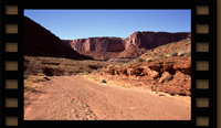
pickups. We seem to pass unnoticed. Past the Taylor camp we pick up the
dirt road, which provides a hard-packed surface and quick going under the
hot sun. A truck passes, its passengers waving and thinking, probably,
"why in the world didnt they drive?" I wonder why in the world they did.
We stop in the shade of a rock overhang around lunchtime, snack on peanuts
and jerky, and air out our hot boots. A cyclist comes laboring up the slightly
but persistently-sloped road. I say hello to him as he passes our shady
alcove and I think I startled him quite a bit. The sun must have made our
shady alcove too dark to see into. After lunch, the breeze picks up and
affects a welcome cooling. Clouds loom on the western horizon. We reach
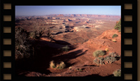
Labyrinth camp on the White Rim Road, just above the Green River, at around
12:30. Water is running low, and we are taunted by a well that has a warning
sign against drinking anything from it. The river sits below a shelf of
rock that forbids easy access, and we walk north along the bustling White
Rim Road, stepping aside for trucks, jeeps and clans of bikers as they
pass. Trail Canyon was completely empty. In Taylor Canyon we saw 5 people.
On the White Rim Road, we see 10 people pass every 15 minutes on some sort
of wheeled vehicle. No hikers. I feel out of place walking on this bustling
road, as if I were attempting to walk in the slow lane on a major highway.
Half a mile north of Labyrinth we investigate a draw that leads to the
river but ultimately it is too steep to access. We decide to doubleback
and hike south on the road and see what comes. By the time we return to
the Labyrinth camp, the sky is completely overcast. We hike south along
the road to Upheaval Bottom, and bushwhack our way through thick tamarisk
and 6-foot-tall dried mustard to the river, where we indulge in filtering
three quarts of thick river water. We let water sit in two pans and I splash
the salt off my face with handfuls of cold river water. After 20 minutes,
there has been no apparent settling of the sediment within. We filter it
anyway and take a bottle of raw water for cooking. A gal we talked with
later in the trip suggested a pinch of allum would settle out the sediment.
As of yet, Ive not tested that tip. Returning to the packs with scratched
arms and soot-blackened pants from the patches of burn that snake through
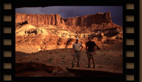
the bottomland, we hop on the trail to Upheaval Dome and make slow headway
in the deep sand of the trail. We encounter the first fellow-hikers of
the trip coming down the trail, a middle-aged man and woman toting small
daypacks and looking happy. The breeze of earlier has increased to mild
wind, blowing sand in gusts. The trail snakes across a wide open plain
of stabilized sand dunes and sparse vegetation, and in the distance the
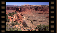
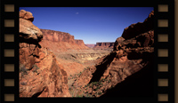
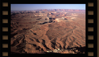
knotted crown of Upheaval Dome sits on the horizon. We enter Upheaval Canyon
and decide to pitch camp near the wash against a east-facing rock wall
(ostensibly to block the wind). It is around 4:00 now: though we made great
time down Taylor Canyon, we lost 3 hours in our search for water. We still
have very little, and I hope that the ranger was correct in his assertion
that we would find water on the Syncline Loop. Lack of water has caused
a little bit of rationing to occur, and I have a headache to show for it.
I take some ibuprofen and try to nap, but it is hot, and every gust of
wind brings a fresh layer of silty sand through the mesh of my tent and
over my naked chest. I doze uncomfortably until around 6 when a group of
hikers on the nearby trail goes past, talking loudly to each other. I get
up and shake out the sand from everything as best I can before securing
the rainfly to ward off future depositions. I take a short walk around
and on top of the wall we are camped by, and find a nice little overhanging
rock to cook dinner under. I return to camp and grab my stuff, and Larry
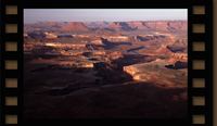
and I go back uphill to the overhanging rock. From this perch, we can see
all the way down to the Green River. The sky is overcast, and it is very
windy. I boil the unfiltered water and it starts to sprinkle. I dine on
jerky, cheese and crackers and M&Ms. Very tasty. The sprinkling abates
and a rainbow streaks out over Upheaval Dome as the sun breaks through
a thin opening on the horizon. Back at camp, I shake the sand out of my
stuff again. Apparently the rainfly is no protection. I take a sponge bath
and treat the two small blisters on my big toe. It is much cooler tonight
than last, around 65F Id guess. I climb in my tent at 8:30 and scribble
notes. At 9, rain comes in pelting waves and I drag my pack under the protection
of the rainfly before going to sleep. The rain continues on and off all
night with incredible gusts of wind that bend and bow the tent. Every gust
brings a wave of fine sand to coat everything. I sleep very fitfully, if
at all. It seems the entire night is spent in a light snooze, like the
kind one occasionally engages in at work. My ears are always alert for
the wind, and when I hear it roaring towards us down the canyon, I cover
my face and chest with my shirt to block the sand, then remove it when
gust subsides. All night this continues. At times, lightening and thunder
shake the sky overhead, and I vaguely hope that the wash we are camped
near will have running water in it come morning.
April 15
Come morning, the sun is out and the
wash is dry as a bone. Even the sand surrounding the tent is dry and powdery
and I wonder how I had heard so much rain when the ground seems so dry.
Two fellows pass by camp, framepacks on their shoulders and we briefly
discuss the turbulent weather of the night. By 9, we are on the trail again
and heading up Upheaval Canyon. The trail follows the streambed most of
the way, and gradually the route is enclosed by ever-steepening walls.
We are low on water, but fortunately we dont have far to go before we
reach the split in the trail at the Syncline Loop. We turn north and follow
the trail only 1/8 mile before encountering two backpackers on their way
down a steep descent of stairs on a cliff. A man and woman who descend
the stairs are from Virginia, and point out that the Syncline backcountry
camp, where we have our first-class reservations, is at the top of the
stairs, and water is in the creek just beyond. They relate to us how the
wind had snapped their tent pole in the night, owing to the exposed location
of the tent. They also relay news of the difficult spot requiring fixed
cables at the top of the canyon. Full of interest, we hurry up the steps
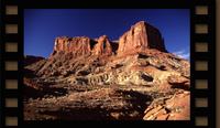
and set up camp on the packed dirt clearing under a beautiful, sunny sky.
We find water in the creek and filter the cool, clear liquid before hiking
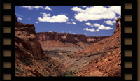
up canyon around noon. The hike is very nice over a rugged and rocky trail
that snakes around the steep red canyon. Pools of water lend a comfortable
feeling to the hike, certainly. After a series of steep switchbacks, the
trail comes to a point where I have to grab onto a cable and swing out
over thin air to a block of sandstone on the other side of the exposed
face. I throw my pack ahead of me, and then its pretty easy to cross.
A heavy pack would almost have to be lowered with rope to make the crossing
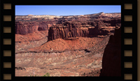
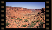
practical. The canyon beyond is a u-shaped affair that drains to the south,
with a giant wall to the west and undulating humps of rock to the east.
Vegetation is abundant. We stop in a dry wash to have lunch and I explore
a shallow alcove to the south where a large overhang has created a deep
plunge pool. I would love to be around to see the water cascade off the
rim 200 feet above, but I imagine one could wait around for a long time
and never catch it. Somewhere along the way, Ive hurt my back, and every
stoop, bend or uphill step sends an unpleasant crack through my lumbar.
I consider all the food we brought that is clearly unneeded, and resolve
to be more realistic regarding provisions on future trips. After our hike
of about 2 miles up, we retrace our steps back to camp and filter water.
We take a short walk up the canyon into Upheaval Dome, then return and
make burritos for dinner in the calm evening. A few wind gusts tear through
the canyon, but I appreciate the lack of sand and hardly mind the wind
at all. The sky is clear and I hop into the tent for sleep at 8:00 and
sleep the best sleep of the trip. The only interruption is the sound of
Larry snoring at 4AM, although the simple fact I can hear him in his tent
20 feet away is testament to how calm and peaceful the night was.
April 16
When I get up, the camp is in the
shadow of the canyon wall, though the sun blares brilliantly on the rocks
down the canyon, and they seem to glow like an orange flame. The sky is
blue and clear. Wonderful day. It is the kind of day I dream of when the
words canyon country are uttered. I eat a bowl of cereal and pack up camp.
We leave just as the sun hits the campsite at 8:45. We head back down the
steep stairs to the trail junction and turn up Upheaval Canyon. The route
is easy, following the wash in the morning shade. I eyeball the rim above
and consider that somehow, we are to end up there, and between here and
there is a lot of uphill. After 30 minutes, it comes. The trail bolts uphill
in steep switchbacks that are relentless for the next 2-3 miles. At least
we are still in shade the entire time. As the trail rises up out of the
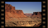
canyon, panoramic vistas present themselves, including a view down the
canyon all the way to the Green River. The wind picks up, and at times
it is a little chilly. We stop twice for breaks, one for a long snack break,
and finally make it up to the Upheaval Dome parking lot at 11:20. The truck
is parked at Alcove Canyon, 1.2 miles away, but Larry volunteers to walk
down and get it. I sit at a park bench and watch the packs, eat a PBJ sandwich
and enjoy the quiet. A few cars come and go. A ground squirrel boldly begs
food from me, but is denied. One car parks and the two fellows inside hike
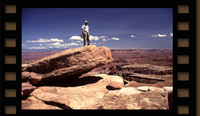
away up the trail. In 24 minutes Larry is back and we take a walk, unencumbered
by heavy packs, to the Upheaval Dome lookout, where we can see down into
the canyon we walked through the evening before.
In the truck and driving for the first
time in 3 days, we cruise down the road a few miles to the Willow Flat
campground and stake out car-camp site #11 for $10. The wind has increased
to a formidable power by now, and it is challenging setting up the tent,
and only possible with the aid of several large rocks. It is pretty chilly
out with the wind blowing, though the sun is shining brightly. We hop in
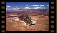
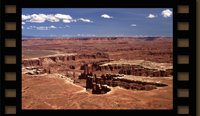
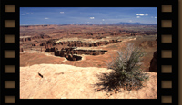
the truck and drive south to various attractions: Buck Canyon Overlook
and Grand View Point. We take the walk to the end of the Grand View Point
and enjoy the awesome perch high above the white rim. Lots of folks crowd
the parking lot, but very few make it out to the end of the trail. Closer
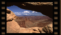
to camp, we take in the short loop trail to Mesa Arch, then hike up to
the Aztec Buttes, both of which house old granaries. In camp again as the
afternoon progresses, we cook up broccoli rice and chicken, and down it
with Doritos and cold Pepsis (the cooler had, amazingly, held solid ice
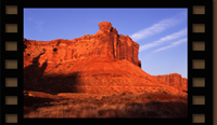
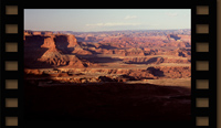
the entire time we were backpacking). Near sunset, we drive to Buck Canyon
overlook and watch the canyon walls glow red before going into shadow.
In camp again after dark, and the wind is ferocious. I actually am glad
of this since it serves to almost completely drown out the noise of nearby
campers. Almost.
April 17
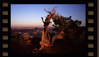
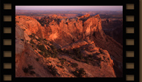
Up before dawn in the bright moonlight,
I dress and wake Larry so we can drive west and take sunrise shots at Upheaval
Dome. Larry is a good sport and gets up right away, though it is cold out.
We get there in plenty of time, but a thin veil of clouds to the east mutes
the suns intensity and creates only moderately crisp colors. The wind
is back at it, and I have to hold my hat on my head to keep from losing
it to the canyon below, where many hats rot away the years, Im sure. We
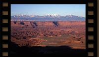
drive back to camp and go see the Green River Overlook, where the cliff
drops away and the White Rim is open below, as well as the Green River.
Nice spot. We return to camp, pack up, and leave by 9:30.
Take a look at more Utah images at
LandscapeImagery.com
Page Created 2/20/07
Send
comments / questions
|
                                          |

;)
;)
;)
;)
;)
;)
;)
;)
;)
;)
;)
;)
;)
;)
;)
;)
;)
;)
;)
;)
;)
;)
;)
;)
;)
;)
;)
;)
;)
;)
;)
;)
;)
;)
;)
;)
;)
;)
;)
;)
;)
;)