| Location: Cache La
Poudre WIlderness, North-central Colorado
Maps: USGS 7.5' Quad: Big Narrows; Trails Illustrated 1:40K: Cache La Poudre/Big Thompson #101 Access: From Ted's Place, drive about 17 miles and pulloff near the Narrows Campground. Wilderness is on south side of the highway. Hiking up the South Fork requires fording the river, which can be very dangerous in spring and summer. Fees: None Trail: None Suggested Parking Area: NAD83 zone 13 463323e 4503667n Elevation: 6450' Weather: Current and recent conditions Local forecast  |
 January,
2004: January,
2004:
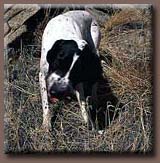
Another typically splendid Colorado morning unfolded before me as I cruised up Hwy 14, past landmarks familiar to those who frequent the Poudre Canyon: Grey Rock, Youngs Gulch, Hewlett Gulch, Red Mt, Sheep Mt, Stove Prairie, Stevens Gulch, Ansel Watrous and Picnic Rock, to name a few. Through the Narrows, where immense rock cliffs tower above the narrow river channel, shadow cast by a low-hanging January sun darkened the road. Only the tips of a few cliffs glowed in the orange sunlight. The river was frozen and cracked in the deep groove just beside the road, with a narrow strip of black, flowing water poking through now and again. As many times as I have found myself up the canyon, there are always so many choices to be made about where to go. I try to explore a new place each time, and I cruised on past a dozen places I had already explored before stopping in a narrow pull-out just outside of the Narrows. Makenzie and Frank, my two
canine companions, popped to their feet in the backseat when the car slowed
to a stop. As I gathered my gear in the pack in the empty passenger seat,
they began to pant and whine, fogging the windows. Being so close to the
road, and my route requiring a crossing of the mostly-frozen river, I decided
to leash them so as to avoid a passing truck smacking one of them as they
inevitably bolted out of the car door, and to keep them away from thin
ice. I got my pack on, got out of the car, opened the back door a crack
and herded the dogs back from the crack with my knee as I clipped a leash
on both of them. Frank is no worry in a situation like this, as he will
stick close under verbal command. Makenzie is another story altogether.
Not yet two years old, but weighing over 60 pounds, her puppy-enthusiasm
is impossible to control by anything not steel, electrical or concrete.
By using a hand-held leash, one can only hope to channel the energy in
the correct direction. I opened up the door fully, and the two pointers
spilled out of the seat like wriggling worms, tails flailing and banging
on the car door, tongues extended in furious panting. I wonder if they
know how ridiculous they look. I herded them as best I could towards the
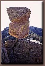
frozen river. A steep slope of loose gravel led Along the crest of the ridge between the two river channels we went, dipping down to a low point where an unique rock formation piqued my interest. A very large boulder, about the size of a VW Bug, was balanced by a pedestal of rock only 10 inches wide. While walking around this balancing act, I heard crunching from Frank down below. I saw him greedily munching a chipmunk. I climbed down to him, carrying Makenzie over a steep boulder incline, and got to him just as he was finishing it off. He chewed contentedly, the furry little tail hanging out of his mouth. Within seconds, he gulped it down and was off again on a new hunt.
I followed roughly the same route down as I had taken up, except that I broke off at the point where Frank made his big kill to head towards the river. The slope was steep, and I actually fell right on my ass a couple of times, luckily avoiding the prickly pear cactus that grew in the dry tallus in fair abundance. I hit the river downstream of the original crossing point, and followed the south bank for some distance, admiring the natural ice sculptures created by the swirling, milky water. Crossing the river the second time was easier since the dogs had run off most of their energy, and the drive home had a lot less panting and window-fogging involved. Unfortunately, by the time we reached home, Makenzies battery had recharged and she was ready to go another 20. 
 |

 down
to the river, and Makenzie pulled so hard that she literally pulled me
down the slope. I couldnt keep my footing, so I fell on my ass and slid
down, bruising my hip and scraping my ass along the ride. Yelling "STOP"
doesnt stop a pointer on a mission. I scolded Makenzie for her painful
exuberance when we came to stop only inches from the ice, and pulled taut
on the leash as we crossed the ice. With ginger steps, the dogs followed
me around the major cracks in the frozen crust. Once on the other side,
I undid the leashes and off they went like rabbits. I plunged into the
sagebrush and mahogany, climbing a steep hill from the north. The vegetation
impeded swift progress up the slope, so I sidled over to bare rock as soon
as I could, and zipped up the bare limestone with ease. The slope was steep
and stepped; at one point I had to lift Makenzie up to the next level,
whereas Frank leapt up like a deer. Above the rocks, the slope was dominated
by grass and widely-spaced shrubs. I zig-zagged up until I reached the
very top, where I stopped and took off my flannel shirt. Gotta love those
sunny Colorado winter days when you can hike around in short sleeves. While
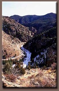
looking around, I noticed I had climbed a ridge between the Poudre and
its South Fork. I had always wanted to hike around the South Fork of the
Poudre, but had never seen it or taken the necessary time to find it. Now,
here it was, right before me, winding up a steep valley towards Rocky Mountain
National Park to the south. The river, frozen and still, lined by deep
green pine trees, was serene and quiet. Birdsongs wafted up the steep slope
from the river. I sat and enjoyed the cooling breeze, the brilliant sun
and the achingly-blue sky. Makenzie brought me rocks to throw, and I obliged
by throwing them as far downhill into the mountain mahogany as I could.
No matter where I threw her rock, her keen sense of smell almost always
led her right to it. Frank spent this time silently stalking unseen quarry
in the shrubs. With the intention of wearing her out some, I threw her
rock for about 30 minutes before moving on.
down
to the river, and Makenzie pulled so hard that she literally pulled me
down the slope. I couldnt keep my footing, so I fell on my ass and slid
down, bruising my hip and scraping my ass along the ride. Yelling "STOP"
doesnt stop a pointer on a mission. I scolded Makenzie for her painful
exuberance when we came to stop only inches from the ice, and pulled taut
on the leash as we crossed the ice. With ginger steps, the dogs followed
me around the major cracks in the frozen crust. Once on the other side,
I undid the leashes and off they went like rabbits. I plunged into the
sagebrush and mahogany, climbing a steep hill from the north. The vegetation
impeded swift progress up the slope, so I sidled over to bare rock as soon
as I could, and zipped up the bare limestone with ease. The slope was steep
and stepped; at one point I had to lift Makenzie up to the next level,
whereas Frank leapt up like a deer. Above the rocks, the slope was dominated
by grass and widely-spaced shrubs. I zig-zagged up until I reached the
very top, where I stopped and took off my flannel shirt. Gotta love those
sunny Colorado winter days when you can hike around in short sleeves. While
looking around, I noticed I had climbed a ridge between the Poudre and
its South Fork. I had always wanted to hike around the South Fork of the
Poudre, but had never seen it or taken the necessary time to find it. Now,
here it was, right before me, winding up a steep valley towards Rocky Mountain
National Park to the south. The river, frozen and still, lined by deep
green pine trees, was serene and quiet. Birdsongs wafted up the steep slope
from the river. I sat and enjoyed the cooling breeze, the brilliant sun
and the achingly-blue sky. Makenzie brought me rocks to throw, and I obliged
by throwing them as far downhill into the mountain mahogany as I could.
No matter where I threw her rock, her keen sense of smell almost always
led her right to it. Frank spent this time silently stalking unseen quarry
in the shrubs. With the intention of wearing her out some, I threw her
rock for about 30 minutes before moving on.
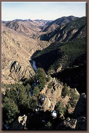
 From
there, the slope of the ridgeline led upward into thick woods. I followed
through the snow, which was not very deep. The valley of the South Fork
opened up to my right, beautiful in its snowy dusting. Frank and Makenzie
cruised ahead of me, scouting the terrain, at one point flushing out a
flock of Ptarmigans. Boy did that rile them up. Everything was kicked up
a few notches when those wings started beating. I stopped at intervals
to sip water and throw pine cones for the dogs to chase. As the incline
steepened, the route to the top grew a little trickier, and I had to back-track
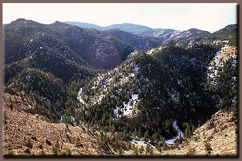
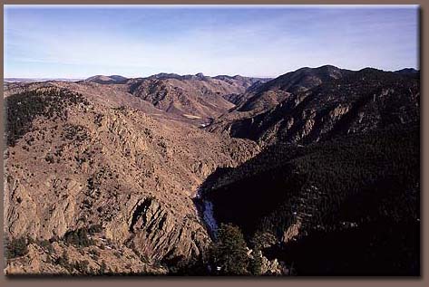
in the face of unworkable cliffs. Finally, I found a way to the very top,
which allowed me to simultaneously view the Narrows of the main channel,
and the valley of the South Fork. I enjoyed the view, but remained concerned
that the brainless beasts would walk right off the cliff edge I was sitting
on. If they understood that certain death was only inches away, they gave
no indication, as they pranced and danced for bits of granola bar. On the
thin strip of pavement below, tiny cars crawled along, almost silent. I
loved the feeling of complete camouflage, high among the trees.
From
there, the slope of the ridgeline led upward into thick woods. I followed
through the snow, which was not very deep. The valley of the South Fork
opened up to my right, beautiful in its snowy dusting. Frank and Makenzie
cruised ahead of me, scouting the terrain, at one point flushing out a
flock of Ptarmigans. Boy did that rile them up. Everything was kicked up
a few notches when those wings started beating. I stopped at intervals
to sip water and throw pine cones for the dogs to chase. As the incline
steepened, the route to the top grew a little trickier, and I had to back-track
in the face of unworkable cliffs. Finally, I found a way to the very top,
which allowed me to simultaneously view the Narrows of the main channel,
and the valley of the South Fork. I enjoyed the view, but remained concerned
that the brainless beasts would walk right off the cliff edge I was sitting
on. If they understood that certain death was only inches away, they gave
no indication, as they pranced and danced for bits of granola bar. On the
thin strip of pavement below, tiny cars crawled along, almost silent. I
loved the feeling of complete camouflage, high among the trees.