Stevens Gulch is a short, steep gulch that drains from the north into the
Poudre River between Sheep and Red Mountains, just north of the eastern
edge of Buck Ridge, which I hiked in 2003. Drivers along Hwy 14 see only
a picnic stop, and officially, that's all there is. However, in the winter
time, when the river is frozen, it's a cinch to walk across the river to
the north bank and hike up the gulch. I suppose there's no reason that
one couldn't also just get wet and wade across in the sumer time at low
flow, but if it's warm enough to ford the river in comfort, it won't be
cool enough to keep one from heat exhaustion on the bare, treeless slopes
around Steven' Gulch. There's no real destination, just the opportunity
to freelance explore rugged, untrailed terrain. My first exploration
of this area took place in February 2002, when the weather proved much
too nice to be at work.
I parked the car in the picnic lot at around 9AM, then walked across the
frozen river, skipping over the thin ribbon of running water in the middle.
Frank followed behind, on leash for the river crossing since I have 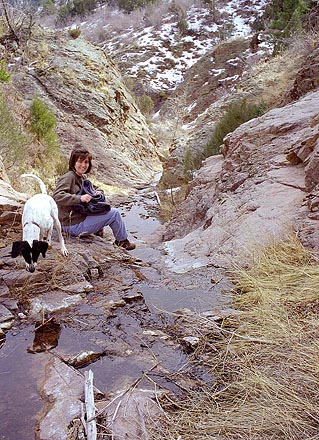 this
phobia of him disappearing under the ice. Once safely on dry land beyond,
I let him off leash and he began the frantic circling/sniffing routine
that is hiking for Frank. Search and sniff, perhaps think about destroying,
or maybe running away. Fortunately we don't run into many things that require
that choice. The gulch was dry except for a few frozen puddles now and
again, and we tromped along the gently inclined sandy wash. Dried grass
and mountain mahogany, with an occasional juniper, lined the gulch. One
area required a little rock scrambling, and fortunately it was dry enough
that my boots could get a good grip on the rock to propel me up. After
about 200 yards, the gulch forked, and I took the left fork up to a giant
flat rock in the bottom of the draw. Its surface was smooth, about 15 feet
wide and 20 feet long and gently sloped. I laid down and relaxed in the
warm spring sunshine. After that short repose, Frank and I went up and
over the ridge dividing the two forks, and continued on up the right fork.
Eventually it petered out onto expansive south-facing slopes, full of cactus
and bunch grass, but no trees or shrubs. We angled east and uphill, gaining
increasingly better views of the surrounding terrain. I was feeling pretty
darn good until I walked right into the front yard of a house. I had no
idea there were any houses up there, so it was a rude awakening. I sidehilled
around to the east and continued on, only to emerge form a ponderosa grove
to see yet another house, built in the mountain log-home style, arrogantly
perched on the highest point of a south-facing ridge. Again, I was dissapointed
at that. I guess it's a free country and folks can build where they want,
but it seems like spoiling a beautiful place to me. No house ever beautifed
a mountain. this
phobia of him disappearing under the ice. Once safely on dry land beyond,
I let him off leash and he began the frantic circling/sniffing routine
that is hiking for Frank. Search and sniff, perhaps think about destroying,
or maybe running away. Fortunately we don't run into many things that require
that choice. The gulch was dry except for a few frozen puddles now and
again, and we tromped along the gently inclined sandy wash. Dried grass
and mountain mahogany, with an occasional juniper, lined the gulch. One
area required a little rock scrambling, and fortunately it was dry enough
that my boots could get a good grip on the rock to propel me up. After
about 200 yards, the gulch forked, and I took the left fork up to a giant
flat rock in the bottom of the draw. Its surface was smooth, about 15 feet
wide and 20 feet long and gently sloped. I laid down and relaxed in the
warm spring sunshine. After that short repose, Frank and I went up and
over the ridge dividing the two forks, and continued on up the right fork.
Eventually it petered out onto expansive south-facing slopes, full of cactus
and bunch grass, but no trees or shrubs. We angled east and uphill, gaining
increasingly better views of the surrounding terrain. I was feeling pretty
darn good until I walked right into the front yard of a house. I had no
idea there were any houses up there, so it was a rude awakening. I sidehilled
around to the east and continued on, only to emerge form a ponderosa grove
to see yet another house, built in the mountain log-home style, arrogantly
perched on the highest point of a south-facing ridge. Again, I was dissapointed
at that. I guess it's a free country and folks can build where they want,
but it seems like spoiling a beautiful place to me. No house ever beautifed
a mountain.
I continued on east towards Red Mountain, now clearly in view. I considered
attempting to climb it, but a steep draw separated us, and the constant
sidehilling route I had taken (since apparently the ridgetops are all private
property) had caused hot spots all over the bottom of my feet. I saw two
people in a truck drive up as I sat watching Red Mountain. As they got
out, I turned and dropped out of view on my way down the slope. They must
hve wondered where in the heck I had come from since all the houses and
roads were the other way. I'm sure not too many people walk up there from
the river. Frank and I took a more direct route down and ended up on the
north side of the river well east of where we had crossed. No problem.
We simply walked on the frozen river to the car to end the trip.
The second time I visited the area was with Andra and Frank the next month,
whcih was March 2002. We didn't intend to hike far, instead just looking
for a place to relax and read our books in quiet. I told her about that
big flat rock up the draw, and she thought that sounded like a nice place
to sit and read. Turned out it was. Frank got pretty bored with us just
sitting there, so he began randomly digging holes at the base of the rock
in the soft soil at the bottom of the draw. We encouraged him by tossing
pebbles down the draw, which he would chase, locate, and then dig at until
a small hole was created. It seemed to entertain him, and it definitely
entertained us. |