
| Location: Comanche Peak
Wilderness, Colorado; On the northern border of Rocky Mountain National
Park
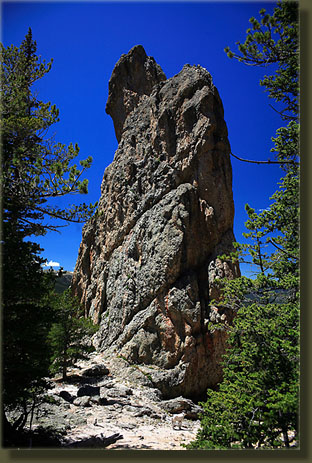
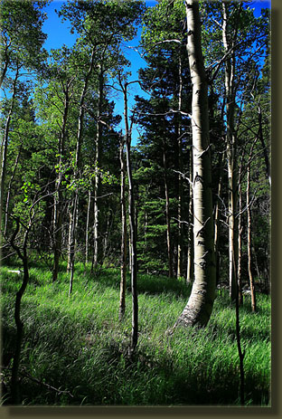
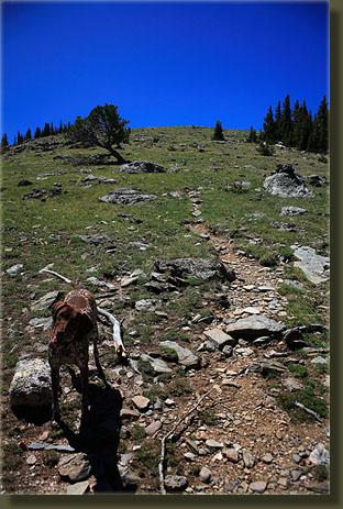
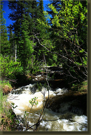
Maps: Trails Illustrated 1:40K: Poudre River / Cameron Pass #112; 1:24K Pingree Park Access: From Ted's Place at Hwy 287 x Hwy 14, head west on the Poudre Canyon Highway for 25.7 miles, then take the Pingree Park Rd (63E) south 13.2 miles to the trailhead, marked by a simple sign that reads "Signal Mt". Park along the road. You can also access Signal Mt from the south via the Dunraven Trailhead on 51B near Glen Haven, but I havent ever gone that way. Trail: From Pingree Park Rd, it is 5.6 miles one-way (USFS sign), mellow for first half trending towards steep and strenuous near the end. 2,660 elevation gain from the trailhead. Fees: None Dogs: Voice control up to the wilderness boundary, then leash control Weather: Current and recent conditions Local Forecast I often passed the simple sign designating the Signal Mt trailhead along the Pingree Park Rd on my way to the Emmaline Lake trail over the last decade. Finally, one fine June morning in 2007, I made that my destination. Frank and Makenzie, two German Shorthaired Pointers who have no choice but to hang out with me, endured my frequent stops along the Poudre River to take photographs in the glowing morning light before we finally made it to the trailhead, which is simply parking the car along the roadside, at around 9:15. Only one other car was parked along the road; it was a Tuesday, afterall. With my two eager canine companions leading the way, I stepped off the road to the east and down a gentle slope along a narrow gravel path that cut through the lush greens of early summer in the mountains. The morning was warm, and not a cloud graced the sky. Hiking was doubly delicious because I should have been sitting in front of a computer at the office, working away towards something that may or may not contribute something meaningful to civilization. It was a Tuesday, afterall. The trail crossed a small stream flowing briskly and lined with willows, then rose in elevation to cross a dry, pine-laden ridge from which one could see a few simple cabins to the west by the stream. Then the trail dropped again to the east towards Pennock Creek, which it soon crossed. Pennock Creek was rolling along very well, with a deep, rustling current that smacked against the rocks and roiled away in eddies of white foam. It was too much for Makenzie, who rarely lets pass the opportunity to get really good and soaked, and she stuck with the footbridge for crossing. A nice waterfall created a dull roar near the crossing. For the first 4 miles, the trail stuck to the bank of Pennock Creek, crossing twice, and leading gently upward through the Ponderosa Pine/Douglas Fir forest. Occasional meadows opened up to the east, but mostly it was a forested and shaded hike. We cruised along at a brisk pace and came upon a single hiker, whom we passed as she stepped off the trail. Makenzie paid no heed to her, and Frank only gave a quick sniff. In the woods, humans arent very interesting, it seems. Shortly after the last stream crossing, the trail turned difficult as the terrain steepened and the shade lessened. I was soon sweating heavily and sucking down giant gulps of water. Incidentally, Desani and Aquafina, Coke and Pepsi brands of bottled water, are both merely bottles of filtered municipal water ony marginally more pure than what you get from the tap, yet they control 25% of the bottled water market. Sweat had soaked my shirt to the point that I dared not remove my backpack for fear of how cold it would be to put it back on. You know what Im talking about there, right? As the trail turned to the southeast from its predominantly eastern heading, we came upon a stone monolith about 60 feet high, surrounded by relatively barren gravel. From there on, limber pines dominated the canopy with their sparse limbs. We came to the junction with the Lookout Mt trail on its way to Donner Pass, and turned due south and uphill to the summit of Signal Mt. Shortly past the junction, I could hold back on lunch no longer and I wolfed down half my peanut butter sandwich, splitting the other half with the dogs, who looked hungry. Back on the uphill trail, the trees gave way to open tundra and sunshine, and my pace slowed considerably as I slogged up the steep grade in the thin alpine air. Wildflowers bloomed in profusion all around, and with each step I caught more glimpses of surrounding peaks. The wind was formidable once I was out in the open, and I donned my fleece shirt, which was only just enough cover to provide comfort. A flock of ravens were hovering in the high wind just above the tundra, and were harrying a large gray and white hawk. As I watched them boldly swoop and peck at the hawk that was 3 times their own large size, the hawk dove towards one, came within inches of snatching it in talons, and pulled out of the dive so close to me that I could clearly see both its eyes. It seemed surprised to see me and deftly averted its course to avoid flying into me. Good for both of us, that. All around, I could see familiar peaks, both those I had visited, and those I have not. Gray Rock shone like a tiny anthill to the northeast, beyond the double-peak of Lookout Mt. To the northwest lay Comanche Peak, still cloaked in snow. Due west and not so far away, the Stormy Peaks rose up into the sky. Far to the south stood Longs Peak and the glacier-carved wall above Bear Lake and Loch Vale in Rocky Mt National Park. Down in the valley to the northwest I could clearly make out the 1994 Hourglass Fire that destroyed some of the CSU mountain campus, and was the reason we had our freshmen retreat at the YMCA in Estes Park rather than at Pingree Park. The trail to the actual summit is faint and I lost it several times despite the cairns in place. I pulled off my pack when I reached the top (ignoring the cold back) and ate some dried mangos and they were divinely sweet after the long uphill slog. Makenzie brought me a rock, hoping to play her favorite game of fetch, while Frank sat still and quiet, looking out over the valley to the south and for all the world it seems when he does that he is simply enjoying the view. Frank and I have been hiking together for 10 summers, and he's always been very circumspect in the wild, contemplative, like Thoreau reincarnated as a mouse-eating canine. It took about 2.5 hours to reach the summit from the Pingree Park Rd, which I have since discovered is one of the longer ways to get to Signal Mt. We three walked down the south face of the bald mountain and over to South Signal Peak, slightly lower but offering a slightly better view of Estes Park to the south. We strayed into Park territory as we circled the peak. I found a nice wind-protected cove in the rock, and sat for a spell to soak in the snow-capped peaks to the south. I guzzled more water, but sensed it was not enough in this dry air. I returned to the summit of Signal Mt
with my shirt snapping like a flag in the west wind. Detouring around a
snowfield, I came once again to the north face of the mountain, and then
retreated back the way I had come, having spent roughly an hour enjoying
the high points. During the hike back from 12:45 to around 3:00, the trail
was a good deal less shady and a good deal hotter than on the hike up.
I was glad at least I was heading downhill. When I reached Pennock Creek,
I stopped and briefly dipped my hot feet into the frigid water, but could
stand the bone-numbing chill for only a few seconds before pulling them
out to dry. I ended up getting a nice fat blister on a toe, despite sock
liners. The dogs tossed themselves into the water and cooled off, perking
up considerably. We reached the car at around 3:00, and drove on
back to town.
|
;)
;)
;)
;)
;)
;)
;)
;)
;)
;)
;)
;)
 |
 Page Created 6-28-07
|
;)