Sierra Madre
Rim
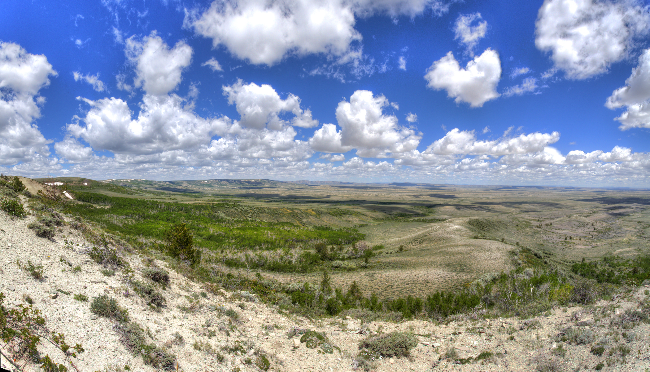
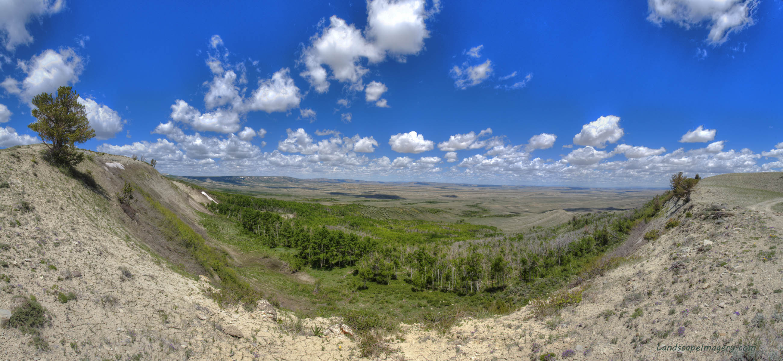
View Larger Map My friend Griff and I are on a short mission to examine the future home of the largest wind farm in North America (I see this stat in press statements frequently, yet I have found no evidence supporting the implication that Central or South America has a larger one.) The enterprise will be located south of Rawlins. This is a remote area, mostly comprised of a mixture of public and private rangeland, with a few summer cabins and ranch houses in the mix. Its dry, with trees restricted to sheltered draws and higher elevations. Its also usually quite cold. And windy. The Chokecherry-Sierra Madre wind farm will host up to one thousand 3-megawatt wind turbines. Theres no denying wind turbines change the landscape. What they lack in surface disturbance, they make up for in visual disturbance, as its hard not to notice one thousand 500-foot wind turbines. Thus, our mission: to see the Sierra Madre rim before turbines muck up the view. On a cloudy and cool morning, we rumbled south on Sage Creek Rd out of Rawlins, heading south towards the Sierra Madre range. The Chokecherry Sierra Madre wind farm has two discrete boundaries. The Chokecherry area is closer to I-80, and lies fully in the checkerboard land ownership area, where every other section of land is private. This makes access to the public land within legally impossible, or otherwise a pain in the ass. There may be some easements that a diligent hiker could utilize to get to areas of interest, but in our case it was irrelevant since the southern block, Sierra Madre, lay only half in the checkerboard, with plenty of public land to walk around. We rumbled south on Sage Creek Rd, and turned off just before Sage Creek to head southwest towards the rim, which was clearly visible for miles of our drive. The wind blew stiffly, and thick clouds raced overhead. We motored along the north bank of Sage Creek on a dirt road and, watching the map closely, stopped at a fork in the road that lies just shy of private property, almost due north of Adams Reservoir. The Power Company of Wyoming, the muscle behind the wind farm development, hasnt said exactly where it will put all 1,000 wind turbines, but it seems logical to me that the 8,000 foot windswept rim to the north of us would be an excellent location to site at least some of them. We loaded our day packs and headed north, aiming for the rims eastern edge that drops away hundreds of feet to the basin beyond. Wind energy is on the rise in the United States, and Im all for it. Wind turbines harvest a renewable resource and dont involve poisoning groundwater (fracking), poisoning air (coal) or poisoning foreign relations (mideast oil). Anyone who has driven through Wyoming on I-80 would agree that Wyoming has plenty of wind to spare for wind turbines. Anyone who lives in Wyoming hopes the wind turbines might slow that wind down. I am in the latter group, and sometimes I hate the wind. Often I curse it. Out loud. From October through May it blows every day, and not just a quaint breeze. It blows 30 mph on a normal day, 80 mph on exceptional days that happen about a dozen times each year. Ive seen the online wind gauge at Buford on I-80 read 95mph in just the last year. As Pacific fronts are ferried along by the jet stream, they pass over land that is constantly gaining elevation, compressing the air between earth and space and increasing its velocity, akin to squeezing your thumb over the water hose end to create a jet spray. The result is an almost endless torrent of wind, a river of air that roars across the Wyoming plains and peaks most of the year. In fact, many places in Wyoming are unsuitable for wind turbines because the wind is too strong, and would exceed the efficient operating range of the turbines, or outright destroy them, as was the case with a toppled turbine near Arlington, Wyoming in 2011. True, the wind accounts for Cheyenne having the cleanest air of any city over 50,000 in the country, despite the city fathers wisely zoning for a petroleum refinery a mile a half from the state capitol. I havent seen any statistics on it, but I have to think the wind partially accounts for Wyoming having the smallest population of any state in the country. (Also a factor: the penchance for city fathers to zone for petroleum refineries a mile and a half from the state capitol). So, there are a few benefits. Overall, however, I usually hate it. So, is it possible such a fiendish presence could produce energy? It is, and it does. I am all for it, and I fervently hope all those turbines can slow down the wind just a little bit. Griff and I hike up through an odd limber pine forest where the ground is virtually devoid of vegetation. Its just soil. Odd. In the two draws we pass through, the aspen is thick and the understory is incredibly lush. Large snowbanks line the eastern slopes below the rim, and water trickles down generously into the aspen forests below. Aerial photographs show the effect quite clearly, with barren uplands all around, and patches of electric green in the draws below the rim. We fortuitously timed our arrival with peak serviceberry bloom, and patches of the hillsides were snowy white with their flowers. We hiked up the first large hill to the north of the road. Near the top, the grass was cropped short by the wind, and the white rocks that covered the ground were spotted with bright orange lichens. We hiked west along the rim with the steep hundred-foot dropoff to the northeast and a gentle grassy slope to the southwest. The wind was present, but mercifully light. We reached a dirt two-track and followed it a ways. Presently we passed by a lone T-post hammered in the ground on the rim. A half mile on, we passed another lone t-post hammered in the ground. Ill bet those t-posts grow into wind turbines in a year or two. Despite their clean energy image, which is well-deserved, wind turbines are not saintly. They may not emit CO2, but the landscape is irrevocably altered by their presence. Unlike a small natural gas well, which may be hardly noticeable if well-sited in a draw or swale, a 500-foot wind turbine that stands nearly twice as tall as the Statue of Liberty refuses to be incognito, especially when erected on treeless, windswept ridgelines. And painted bright white. With blinking lights day and night (thats an FAA thing). Nope, you cant ignore an industrial wind turbine. Plus, each turbine must be maintained, and to do that there must be roads to every turbine. And, since they are both using and generating electricity, every turbine must be wired into the grid, usually by cables buried in the ground through great plastic conduits. Theres a lot of disturbance that goes into installation of wind turbines, but once operational, the footprint is small, except perhaps for the roads. They say that only 2,000 acres of this massive area will be disturbed long-term but of course that depends on what you consider long term. Any disturbance in this cold high desert takes decades to recover. Two tracks established for uranium surveys in the Red Desert that were driven in the 60s and not since are still plainly visible. Sagebrush takes dozens of years just to establish seedlings, and decades more to grow to maturity. So, perhaps in a century there will be only 2,000 acres disturbed, but for the lifetime of my children the area will have significantly greater surface impact. Aside from ground disturbance, theres solid evidence that wind turbines are diabolical bird killers. The blades of the giant turbines seem to spin slowly, but the tips of those blades can reach speeds of 200 mph. Birds often cant dodge a truck running 65 mph on a highway, much less a giant blade swathing through the air at 200 mph. Estimates from dozens of scientists place the number of birds killed in flight by wind turbines in the millions, and thats with a relatively small area of land area devoted to wind farms. Theres also evidence they kill lots of bats. As if bats needed any more problems. So, while the turbines dont contribute substantively to climate change, they are not without environmental cost. Weighing all factors, though, I tend to still come down on the side of the wind turbines. I lament the loss of pristine skyline views in Wyoming, and the loss of so many birds and bats, but an alternative of runaway atmospheric temperatures from rapidly increasing atmospheric CO2 seems much worse. Below the rim, a few limber pine speckled the eroding white slope. Lower down, aspen groves grew at steep outward angles, bent almost to the ground with annual snowpack. Further away from the slope, the aspen grew straight and tall, in wide groves that spanned the valleys. As the distance from the rim increased, the aspen groves tapered down to narrow Vs, then gave way to lower vegetation like willows and grass, finally fading into thin riparian ribbons that snaked out east between vast swells of dry grass and low-growing sagebrush. The topography creates the lush conditions that allow all those riparian species to flourish so well below the rim. We continued on the rim, enjoying the sunny day and billowy cumulous clouds overhead. As we progressed west parallel to Rasmussen Creek, a great snowbank dozens of feet thick and a mile long lined the rim. The aspen on its fringe, recently unburied, had not budded out, and most of the aspen trunks were actually laying flat on the ground, bent east under the weight of the snow. We crossed a dirt road that headed north into the basin, and kept to the rim for just a short bit longer before deciding to drop down below the rim into the lush forest below. Crossing the snow field, we stamped our feet into the dense snow to chop footsteps down the steep slope. In fact, the snow helped us considerably, for the slope is so steep here that I think trying to head down on loose soil would lead to a fall. After crossing the muddy morass at the base of the snowbank, we entered the cool quiet of one of the most lush aspen groves Ive ever seen. We continued heading west through the thick underbrush of the aspen woods, and found a nice big log to sit on and have a snack. The dappled sunshine, light breeze and warm air combined to make me drowsy, and I think I could have easily slept an hour in the green carpet beneath those aspen. But, the exploration couldnt wait. From time to time we happened upon a game trail that we would follow until it started heading down valley, and then wed leave it to continue paralleling the rim. The snowbank just below the rim was almost constant, and usually visible through the aspen canopy to the south. Over dry ridge, through wet valley, again and again. Quickly, we made our way miles west. We skirted south of a chunk of private land. The Pine Grove Ranch was visible from time to time far below. Almost all the private land in this area is owned by a single entity: the Overland Trail Land and Cattle Company, which is owned by Phil Anschutz. Anschutz, the 38th richest person in America. Anschutz also owns Wyoming Power Company, the entity putting in the wind farm. After a few hours, we decided to try to get back up on top of the rim. Easier said than done. In almost all places, the slope was too steep to tackle, and where it wasnt too steep, it was too muddy. The melting snowbank made gumbo out of the soil. We finally found a potential exit near a small turbid meltpond. We climbed up the dry ridge of the slope, cascading tallus below us, until it got really steep. I stopped and said I would go no farther. Griff kept going, thinking that it would mellow out. It did not, and by the time he discovered this, he was on a pitch so steep and with such loose tallus that he started slipping towards the edge. Having my camera tripod extended and handy, I held it out for him to grab to help him clamber back down to the less steep pitch. Later Griff remarked he couldnt believe he had tried to get across that slope. I couldnt either. But alls well that ends well, and we were soon back down in the relative flat terrain of the aspen forest, continuing west. Another ridge, another valley. More lush aspen and sparkling water coming off in sheets from the snowbanks. When our exit came it was obvious and easy. A long dry slope ramped right up to the top. West of this ramp, the snowbank had crumbled into huge chunks, like a glacier calving bergs to float out onto the sagebrush ocean beyond. We crossed a barbed wire fence, and then we were up on top of the ridge. Getting our bearings, we recognized that we were only a quarter mile from the Continental Divide. So, we hiked up the dry slope of the final hill and sat down on the Continental Divide for a snack and general inspection of the terrain. We discussed good potential wind turbine sites and soaked in the quiet of the rim that wont last long. Thos turbines are not quiet. They sweep through the wind with a swishing sound that you can hear half a mile away, sometimes farther. At 5:00, we decided wed better get back to the car and find a place to camp. The return trip was much faster, since we stayed on the rim and had no obstacles to contend with. Our 5-mile route through the valleys and forests below took 5 hours, while the 4.3-mile rim walk back took only 2 hours. The evening was warm and nearly windless. We arrived at the truck around 7PM, and quickly drove off east, then north below the rim to try to get to Rasmussen Creek. Unfortunately the road was washed out utterly near the old Rawlins aqueduct station, and we had to camp in the sagebrush at that spot. It wasnt a bad spot to camp, but not nearly as enticing as the lush riparian forest along the creek. I slept very well in my cozy tent. June 9
|
;)
;)
;)
;)
;)
;)
;)
;)
;)
A lone T post. Future turbine?
;)
;) |
;)
;)
;)
;)
;)
;)
;)
;)
;)
;)
;)
;)
;)
;)
;)
;)
;)
;)
;)
;)
;)
;)
;)
;)
;)
;)
;)
;)
;)
;)
;)
;)
;)
;)