Location: Roosevelt National Forest,
North-central Colorado
Maps: USGS 7.5' Quad:
Big
Narrows; Trails Illustrated 1:40K: Cache La Poudre/Big Thompson
#101
Access: From Ted's Place, drive about
17 miles and pulloff near the Narrows Campground.
Fees: None
Trail: None. Open terrain is a cinch
to navigate.
Parking Area: NAD83 zone 13 464990e
4503090n Elevation: 6200'
Dog Regulations: Voice control
Weather: Current
and recent conditions Local
forecast
February 2003 was a much-needed
wet month in Colorado, and it brought statewide snowpack up to 88% of normal,
which everyone likes to hear. The downside was that it kept me holed up
in my living room watching snow fall every weekend for 5 weeks stretching
back into January. Thus, when the morning sky was blue and cloudless, and
the temperature was in the upper 40s by 9AM on the second Saturday of
March, I hastily threw some gear in my pack and herded the dogs in the
car for a trip up the Poudre. I had no idea where I was going, but chose
to let the chips fall where they may. Highway 14 had very little traffic
on it, and I drove up with windows cracked, dogs frantically sniffing the
cool air whistling by outside. After passing several nice-looking opportunities,
I finally pulled over into a little dirt patch about ½ mile past
the Stevens Gulch picnic ground. The steep southern-facing slopes stretched
up high to the north, and with little delay the three of us, Frank, Makenzie
and I, were trudging up the grassy, rocky slope in the full sunlight of
a warm spring day.
 The
wind was blowing pretty hard, I was sorry to see, but it was not terribly
cold. The sun on my body in fact warmed me up pretty good. I was comfortable
in a t-shirt, jeans and a flannel. There was no trail that I could see,
so I just switchbacked up the slope, pulling myself up the steep passages
by grabbing onto large boulders. There were no trees on the southern face,
only sagebrush, prickly pear and dried grasses. The dogs ranged ahead of
me in wide sweeping arcs, noses to the ground, busily taking in the wild
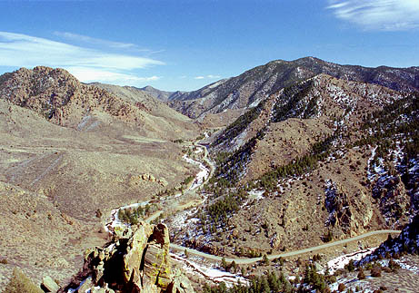
scents. I crested a ridge that afforded a nice view of the Poudre Hwy to
the east, and I could see my former hiking spots at Stevens Gulch and
the spot I parked at near Stove Prairie picnic area (where Andra and I
once stopped to grill hot dogs) to hike up the south slope towards Bear
Ridge in early January 2003. Just before the highway curved out of view
I could see the junction of Stove Prairie Rd, where earlier in the year
they found the body of a missing university student in the woods. Grizzly
distinction. To the west, the canyon was so narrow and twisted that not
much could be seen of the river or the highway before they were blocked
by a mountain. To the north, the top of Sheep Mt had come into view, being
blocked from the highway by its own steep slopes and ridges. The
wind was blowing pretty hard, I was sorry to see, but it was not terribly
cold. The sun on my body in fact warmed me up pretty good. I was comfortable
in a t-shirt, jeans and a flannel. There was no trail that I could see,
so I just switchbacked up the slope, pulling myself up the steep passages
by grabbing onto large boulders. There were no trees on the southern face,
only sagebrush, prickly pear and dried grasses. The dogs ranged ahead of
me in wide sweeping arcs, noses to the ground, busily taking in the wild
scents. I crested a ridge that afforded a nice view of the Poudre Hwy to
the east, and I could see my former hiking spots at Stevens Gulch and
the spot I parked at near Stove Prairie picnic area (where Andra and I
once stopped to grill hot dogs) to hike up the south slope towards Bear
Ridge in early January 2003. Just before the highway curved out of view
I could see the junction of Stove Prairie Rd, where earlier in the year
they found the body of a missing university student in the woods. Grizzly
distinction. To the west, the canyon was so narrow and twisted that not
much could be seen of the river or the highway before they were blocked
by a mountain. To the north, the top of Sheep Mt had come into view, being
blocked from the highway by its own steep slopes and ridges.
 I
followed this ridge up, keeping a nice view to the east open, until the
terrain steepened to the point that I had to sidehill around to the north
side of a craggy sub-peak. On the northeastern side, the snow was deep,
and although the climb up the steep boulders would have been more than
manageable in the summer, the snow worried me, so we turned around and
backtracked a couple hundred yards and circled around to the southwestern
side where there was no snow. I found a chute that allowed a fairly easy
assent up to the craggy sub-peak, and soon all three of us were standing
in the wind, once again looking east at the river and surrounding bottoms.
I followed a saddle leading northwest and began to circle around to the
north side of the mountain. I stepped carefully in the anlkle-deep snow
to avoid getting my socks wet since I hadnt brought gaiters. Giant hilltop
mountain homes came into view to the north, along with the tortuously scarring
network of graded roads and driveways. Nothing looks so out of place around
this area as that. I tried to keep my eyes pointed a different directionand
pretend I was in undisturbed wilderness. Soon I was switching direction
and walking south through huge ponderosa pines and Douglas firs with snow
up to mid calf. The dogs romped about in the snow in a frenzy, and whether
they knew it or not, they spooked a herd of mule deer that went trotting
up into the upper areas of the mountain and out of view. The wind was fairly
well-blocked in the trees, and it was quiet and cool. Before long, I could
see blue sky through the trees, signalling the summit. We came upon the
wind-battered peak, which is littered with Volkswagen-sized boudlers. I
climbed to the tallest one I
followed this ridge up, keeping a nice view to the east open, until the
terrain steepened to the point that I had to sidehill around to the north
side of a craggy sub-peak. On the northeastern side, the snow was deep,
and although the climb up the steep boulders would have been more than
manageable in the summer, the snow worried me, so we turned around and
backtracked a couple hundred yards and circled around to the southwestern
side where there was no snow. I found a chute that allowed a fairly easy
assent up to the craggy sub-peak, and soon all three of us were standing
in the wind, once again looking east at the river and surrounding bottoms.
I followed a saddle leading northwest and began to circle around to the
north side of the mountain. I stepped carefully in the anlkle-deep snow
to avoid getting my socks wet since I hadnt brought gaiters. Giant hilltop
mountain homes came into view to the north, along with the tortuously scarring
network of graded roads and driveways. Nothing looks so out of place around
this area as that. I tried to keep my eyes pointed a different directionand
pretend I was in undisturbed wilderness. Soon I was switching direction
and walking south through huge ponderosa pines and Douglas firs with snow
up to mid calf. The dogs romped about in the snow in a frenzy, and whether
they knew it or not, they spooked a herd of mule deer that went trotting
up into the upper areas of the mountain and out of view. The wind was fairly
well-blocked in the trees, and it was quiet and cool. Before long, I could
see blue sky through the trees, signalling the summit. We came upon the
wind-battered peak, which is littered with Volkswagen-sized boudlers. I
climbed to the tallest one 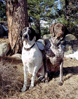 and
stood facing west, bracing myself in a fierce wind. The wind was so strong
that my first attempt at jumping up on the rock failed as I was blown backwards
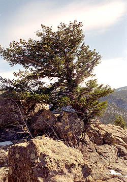
and off to the ground below. A single stunted Douglas fir stood bent before
the wind on the highest point of the summit. Being as cold as it was, we
stayed but a moment, then retreated to the east side where the sun was
still shining but the wind was less severe. I sat down in the deep duff
on the lee side of a giant ponderosa and watered the dogs and snacked myself.
Once again, I had a nice view of the canyon to the east, and the tiny cars
that crawled along almost unnoticed along the ribbon strip of blacktop
that snaked through the valley. To the southwest, I could see the top of
the unnamed peak where the three of us had sat and rested in January just
a little bit higher than I was now. I pulled out my book and read, then
became drowsy, so I laid down and snoozed in the warm sun. The dogs entertained
themselves by chewing on sticks and pine cones. Whatever makes them happy
and keeps them close is fine with me. After a half hour or maybe an hour
I put my stuff together and we began the steep route down. Instead of backtracking
through the snow, we went down the steeper south face. Makenzie found a
deer leg bone on the way down, keeping her and
stood facing west, bracing myself in a fierce wind. The wind was so strong
that my first attempt at jumping up on the rock failed as I was blown backwards
and off to the ground below. A single stunted Douglas fir stood bent before
the wind on the highest point of the summit. Being as cold as it was, we
stayed but a moment, then retreated to the east side where the sun was
still shining but the wind was less severe. I sat down in the deep duff
on the lee side of a giant ponderosa and watered the dogs and snacked myself.
Once again, I had a nice view of the canyon to the east, and the tiny cars
that crawled along almost unnoticed along the ribbon strip of blacktop
that snaked through the valley. To the southwest, I could see the top of
the unnamed peak where the three of us had sat and rested in January just
a little bit higher than I was now. I pulled out my book and read, then
became drowsy, so I laid down and snoozed in the warm sun. The dogs entertained
themselves by chewing on sticks and pine cones. Whatever makes them happy
and keeps them close is fine with me. After a half hour or maybe an hour
I put my stuff together and we began the steep route down. Instead of backtracking
through the snow, we went down the steeper south face. Makenzie found a
deer leg bone on the way down, keeping her 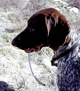 uncanny
streak of locating dead animal parts alive and well. I had to physically
pull her away from it. I picked up the route we had taken on the way up
near the craggy sub-peak, and followed it from there until the time came
to descend the last draw down to the car, where I noted a white pickup
had also parked. I looked around but saw nobody else in view. Instead of
going straight down, I followed the ridge south until it rose again slightly.
At the top of this little peak one can look almost straight down onto the
river below. I followed this ridge for about 30 meters before it became
too steep, then walked back northwest to the draw and followed it down. uncanny
streak of locating dead animal parts alive and well. I had to physically
pull her away from it. I picked up the route we had taken on the way up
near the craggy sub-peak, and followed it from there until the time came
to descend the last draw down to the car, where I noted a white pickup
had also parked. I looked around but saw nobody else in view. Instead of
going straight down, I followed the ridge south until it rose again slightly.
At the top of this little peak one can look almost straight down onto the
river below. I followed this ridge for about 30 meters before it became
too steep, then walked back northwest to the draw and followed it down.
The total trip length was around 2.5 miles
with an elevation gain of around 1200 ft. A good, easy walk for a nice,
lazy spring day |
