Location: Cache La
Poudre Wilderness, North-central Colorado.
Maps: USGS 7.5' Quad:
Big
Narrows; Trails Illustrated 1:40K: Cache La Poudre/Big Thompson
#101
Access: From Ted's
Place, drive about 15 miles to the Stove Prairie Rd. Turn left, then watch
for the gulch within the first 1/8 mile on the right. Parking is very limited.
Wilderness is on west side of the road.
Fees: None
Trail: Follow the
old two-track up the gulch to the mine. Beyond the mine there is no trail,
but follow the gulch to the top of Bear Mt.
Trailhead: NAD83
zone 13 467207e 4502880n Elevation: 6197'
Dog Regulations:
Voice control
Weather: Current
and recent conditions Local
Forecast
Friday 8:30AM, November 18, 2005: The white
winter sun shone through my office window onto the wall, where it only
hits near the solstice. I glanced out the east window to see the pines
standing perfectly still in the morning light. I got that itch, and suddenly
my computer screen seemed like a devil. The elements conspired, and I succumbed.
With one phone call I had secured the remainder of the day off, and in
20 minutes I had returned home, stashed essential hiking gear into my backpack,
corralled the dogs and was on my way south, towards the sun. I had worn
thick hiking socks to work that morning
.did my subconscious know?? While
speeding along the empty pavement of I-25, I 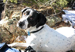 threw
glances at the open map in my lap. Where to go? The Poudre Canyon was my
destination, since hiking in Wyoming anytime between October and May is
a lot like being sandblasted. The Poudre Canyon, by contrast, is not often
terribly windy, and when it is, not as bad as Vedauwoo, trust me. So, up
the Poudre canyon, but not too high since I want to get there quick, and
I dont want snow. Youngs Gulch? I pondered this lovely canyon near Gray
Rock, but ultimately decided I needed something new and unfamiliar. I studied
the Poudre Wilderness, since this is a sure way to see something new. I
noted SKin Gulch on the map running SW from near the junction of Hwy 14
and Stove Prairie Rd, just south of my hike up on Buck Ridge a few years
ago. This looked good, so I put the map away and concentrated on driving.
I bypassed Fort Collins through Wellington and ended up on Hwy 1 north
of town, then cruised northwest under achingly-clear skies towards Teds
Place. West onto Hwy 14 and into the beautiful, comforting canyon walls.
How long had it been? Only a month since I was last here, but it felt like
much longer. threw
glances at the open map in my lap. Where to go? The Poudre Canyon was my
destination, since hiking in Wyoming anytime between October and May is
a lot like being sandblasted. The Poudre Canyon, by contrast, is not often
terribly windy, and when it is, not as bad as Vedauwoo, trust me. So, up
the Poudre canyon, but not too high since I want to get there quick, and
I dont want snow. Youngs Gulch? I pondered this lovely canyon near Gray
Rock, but ultimately decided I needed something new and unfamiliar. I studied
the Poudre Wilderness, since this is a sure way to see something new. I
noted SKin Gulch on the map running SW from near the junction of Hwy 14
and Stove Prairie Rd, just south of my hike up on Buck Ridge a few years
ago. This looked good, so I put the map away and concentrated on driving.
I bypassed Fort Collins through Wellington and ended up on Hwy 1 north
of town, then cruised northwest under achingly-clear skies towards Teds
Place. West onto Hwy 14 and into the beautiful, comforting canyon walls.
How long had it been? Only a month since I was last here, but it felt like
much longer.
Dark canyon shadows flickered on the glass
of the windshield as I cruised smoothly around bends and winds in
the road, following that fickle route of the river. I turned south on Stove
Prairie Rd and watched carefully for signs of a gulch. I saw it coming:
a cleft in the ridge, obscured by cottonwoods. To my surprise, two cars
were parked in a small pullout right at the mouth of it. Perhaps, I pondered,
this place is a common hiking route. With no place to pull off and with
steep shoulders along the road, I continued on the road about 100 meters
to a second pulloff. I stepped out of the car and instantly determined
that no heavy jacket would be needed today, so that went into the trunk.
I shouldered my backpack at 10:20 and let the dogs out, cautioning them
to stick close as we walked back towards the mouth of the gulch along the
vacant blacktop. A definite trail led west into the woods, and we followed.
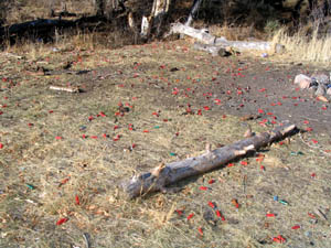 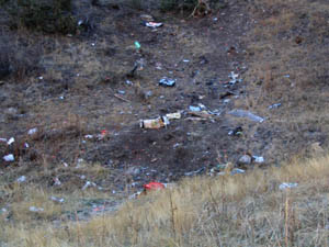
Almost instantly I noted the presence of shotgun
casings littering the ground. Red, yellow and blue plastic tubes with brass
ends lay all around, mixed in with day-glo clay pigeon shards and a host
of brass .30-caliber shells. I continued on up the trail until I came to
a clearing, denuded of most vegetation, but festooned with hundreds of
thousands of shell casings and assorted rubbish. Toilet paper lay in piles
and streaks all around. Burned wood and charcoal , plastic bags, cardboard
boxes and hundreds of pounds of glass shards littered an area the size
of a basketball court. Unidentified bones with meat and fur clinging tenaciously
to them poked through the dismal scene, attracting the attention of the
dogs. In short, it was a completely trashed area. I see in this the same
mentality of smokers who toss their butts on the ground, somehow imagining
that now that they are done with them, they will magically disappear on
their own accord. I cant imagine that the typical hunter is guilty of
such a disrespectful act, but apparently there is quite a number of folks
with guns willing and ready to simply throw their garbage on the ground
and think of it no more. As I suspected, once I walked about 200 yards
from the road, the litter cleared. This is about the distance your average
fat-assed redneck will walk with his shotgun to shoot at beer bottles,
and beyond that, it is sure to be pristine. This is also, by the way, an
outstanding demonstration of the need to limit road building in national
forests. Trash follows the roads everywhere you go.
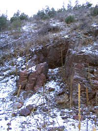 In
a short while, perhaps no more than ½ mile, the trail intersected
a fence, and the remains of Hole in the Wall mine, the entrance of which
has been blocked almost entirely by gravel and rock. Any sort of trail
faded out completely at this point, so I continued on through the shade
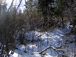
and thin layer of snow. Even in the cool of the trees, however, it was
quite warm, and I took off my sweatshirt and tied it around my waist to
continue on in short sleeves. I came to a fork in the gulch, and took the
left fork primarily because the right fork looked snow-packed, steep and
uninviting. Ponderosa pine and Douglas fir created a canopy
of green, broken only by sharp rock points at rare intervals. In the middle
of the ravine, birch and aspen grew thick as grass. The In
a short while, perhaps no more than ½ mile, the trail intersected
a fence, and the remains of Hole in the Wall mine, the entrance of which
has been blocked almost entirely by gravel and rock. Any sort of trail
faded out completely at this point, so I continued on through the shade
and thin layer of snow. Even in the cool of the trees, however, it was
quite warm, and I took off my sweatshirt and tied it around my waist to
continue on in short sleeves. I came to a fork in the gulch, and took the
left fork primarily because the right fork looked snow-packed, steep and
uninviting. Ponderosa pine and Douglas fir created a canopy
of green, broken only by sharp rock points at rare intervals. In the middle
of the ravine, birch and aspen grew thick as grass. The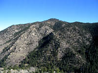 route
up the left fork was not too much better so it wasnt long before I was
hiking out of the gulch to attain the ridge on the east side. Out in the
open I found easy walking through the bare mountain mahogany and wheat
grass. An occasional ponderosa pine provided shade for a water break in
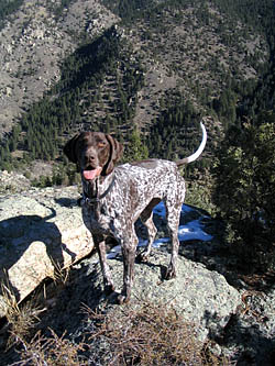
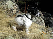
the warm sun. What a nice November day. Frank and Makenzie trotted along
with me, sometimes in front, sometimes in the rear, sometimes out of sight
to the point I had to whistle for them to return. When I got to the top
of the ridge at 11:20, I looked down to the east and saw Stove Prairie
Rd, leading south to a very large clearing that I can only assume is Stove
Prairie itself. Just a little further east sat Youngs Mt, a peak I have
climbed a few times before. I followed the ridgeline west past an-open
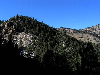
dip to the northeast face of Bear Mt. The dogs appreciated a return to
the snow as they ate mouthfuls of it with each step. The slope was very
steep, and the snow made it difficult to get a good purchase on the rocks.
I found myself relying heavily on the thick growth of pines and fir to
aid me in getting higher. Around this time the wind picked up from its
previous dead-calm. At around 12:00 I came back into the sunlight
at a rocky high point along the oblong shape of Bear Mt. I sat down
in the sun and drank some water and ate a granola bar. route
up the left fork was not too much better so it wasnt long before I was
hiking out of the gulch to attain the ridge on the east side. Out in the
open I found easy walking through the bare mountain mahogany and wheat
grass. An occasional ponderosa pine provided shade for a water break in
the warm sun. What a nice November day. Frank and Makenzie trotted along
with me, sometimes in front, sometimes in the rear, sometimes out of sight
to the point I had to whistle for them to return. When I got to the top
of the ridge at 11:20, I looked down to the east and saw Stove Prairie
Rd, leading south to a very large clearing that I can only assume is Stove
Prairie itself. Just a little further east sat Youngs Mt, a peak I have
climbed a few times before. I followed the ridgeline west past an-open
dip to the northeast face of Bear Mt. The dogs appreciated a return to
the snow as they ate mouthfuls of it with each step. The slope was very
steep, and the snow made it difficult to get a good purchase on the rocks.
I found myself relying heavily on the thick growth of pines and fir to
aid me in getting higher. Around this time the wind picked up from its
previous dead-calm. At around 12:00 I came back into the sunlight
at a rocky high point along the oblong shape of Bear Mt. I sat down
in the sun and drank some water and ate a granola bar.
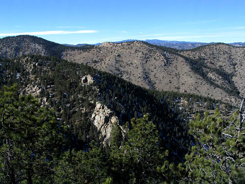
  From there I walked south to the true summit
of Bear Mt, and sat again in the sun to eat my apple, the core of which
went to Frank, who relishes such a treat. The view was spectacular to the
north and east, although obscured to the south and west. Nevertheless,
it is always fun to get high up in this rugged terrain and have a look
around. The significance of the Poudre Wilderness lies not in towering
mountains, alpine meadows or glacier gorges that most other Colorado wilderness
areas are known for. Instead the Poudre wilderness embodies in a very simple
way the original idea of the Wilderness Act: to preserve wild land forever
from development and mechanized transportaion. In this case, that preservation
is more meaningful because the thread of development and mechanized transportation
is more immediate. Unlike alpine crags and 14,000-peaks, this low-elevation
wilderness area, if not designated, would surely be under development pressure
similar to the type that has already colonized the north side of the canyon.
One can see roads and houses from Bear Mt just across the Poudre River.
If not for wilderness designation, would roads and houses stand right here?
A second significant aspect of the Poudre wilderness is that there are
no significant trails through it. The Mt McConnell trail makes a brief
foray into wilderness, but for less than a mile and it never punches more
than about 1/4 mile deep. No other route, maintained or otherwise, exists.
When you're in the Poudre wilderness, you are on you own, and that's a
very fun state to be in. An unusual part of this section of the hike were
the large patches of young Douglas fir, most no more than 6 feet high but
clumped together with trunks only inches apart. Ive never seen this type
of growth at this low of an elevation, and yet there were very tall trees
spaced further apart all around. From the summit of Bear Mt, I walked
west to the head of the east fork of Skin Gulch, which I dropped down into
around 1:00 and started heading back to the car.
From there I walked south to the true summit
of Bear Mt, and sat again in the sun to eat my apple, the core of which
went to Frank, who relishes such a treat. The view was spectacular to the
north and east, although obscured to the south and west. Nevertheless,
it is always fun to get high up in this rugged terrain and have a look
around. The significance of the Poudre Wilderness lies not in towering
mountains, alpine meadows or glacier gorges that most other Colorado wilderness
areas are known for. Instead the Poudre wilderness embodies in a very simple
way the original idea of the Wilderness Act: to preserve wild land forever
from development and mechanized transportaion. In this case, that preservation
is more meaningful because the thread of development and mechanized transportation
is more immediate. Unlike alpine crags and 14,000-peaks, this low-elevation
wilderness area, if not designated, would surely be under development pressure
similar to the type that has already colonized the north side of the canyon.
One can see roads and houses from Bear Mt just across the Poudre River.
If not for wilderness designation, would roads and houses stand right here?
A second significant aspect of the Poudre wilderness is that there are
no significant trails through it. The Mt McConnell trail makes a brief
foray into wilderness, but for less than a mile and it never punches more
than about 1/4 mile deep. No other route, maintained or otherwise, exists.
When you're in the Poudre wilderness, you are on you own, and that's a
very fun state to be in. An unusual part of this section of the hike were
the large patches of young Douglas fir, most no more than 6 feet high but
clumped together with trunks only inches apart. Ive never seen this type
of growth at this low of an elevation, and yet there were very tall trees
spaced further apart all around. From the summit of Bear Mt, I walked
west to the head of the east fork of Skin Gulch, which I dropped down into
around 1:00 and started heading back to the car.
The gulch was very slow walking. Birch grew
in abundance, and the low, angled trunks made it difficult to get past.
The rocks, moss and snow did not help. I slipped many times, but avoided
falling, luckily. Still, this part of the hike was exceedingly pleasant.
The sun shone down in the gulch, and the air was warm and calm. The dogs
were also having a fine time rollicking back and forth in the snow.
I encountered one fo the biggest Ponderosa pines Ive ever seen right next
to the trickle of clear water. The grade dropped steeply. As the gulch
became deeper, the shade grew until the sun was blocked out entirely. In
this area, both the snow and vegetation were thicker, and the going was
a bit more difficult. I tried hiking up out of the gulch with the intent
of remaining on the ridge crest, but the rocky outcroppings along the ridgeline
made this impossible. The further down I went, the slower the descent became,
until I was making hardly 20 feet a minute. I had to carefully test each
snow-covered rock to see if it would hold my weight, then push through
thorns and branches that pulled at my shirt and knocked my hat off. The
dogs didnt have it much better as the undergrowth seemed to only intensify
closer to the ground. I spent a good hour monotonously zig-zagging back
and forth across the damp gulch, trying not to fall. I cannot recommend
this section of Skin Gulch for hikers during the winter because of the
snow, and even in summer I wonder how pleasant the hike would be, what
with the dense undergrowth holding you back at every step. The steep
slopes I was walking down began to make the bottoms of my feet burn and
I could feel blisters growing. Nothing to do but continue down. I acquired
a stiff pine limb to act as a walking stick and this helped the process
of staying on two feet. Through clearing in the trees, I could see the
first ridge line I had hiked up, and gauge my relative progress towards
intersecting the route I had come up. I was, in fact, descending the very
gulch that I had before passed up as looking not-so-inviting.
 In
perhaps less time than it seemed at the time, I reached relatively level
ground, and began to retrace my steps back towards the car. Shots were
echoing from the mouth of the gulch. I recalled hearing shots while hiking
along Buck Ridge, and wondering where there were coming from. Now I know.
As I approached the trash-garnished clearing, I yelled out monsyllables
to warn of my approach. The shots stopped just before I entered the clearing
to see three fellows in their early twenties in the process of emptying
a box of 10-guage and clay pigeons. They said hello and were friendly.
Id like to think they were dropping all those used casings back into the
box from which they came, but I didnt stop to ask about it. Instead we
exchanged in small talk about the trail, and I continued on. Just after
I was out of sight, the staccato blasts began again, and continued until
I got back to the car and drove away at around 3:00. In
perhaps less time than it seemed at the time, I reached relatively level
ground, and began to retrace my steps back towards the car. Shots were
echoing from the mouth of the gulch. I recalled hearing shots while hiking
along Buck Ridge, and wondering where there were coming from. Now I know.
As I approached the trash-garnished clearing, I yelled out monsyllables
to warn of my approach. The shots stopped just before I entered the clearing
to see three fellows in their early twenties in the process of emptying
a box of 10-guage and clay pigeons. They said hello and were friendly.
Id like to think they were dropping all those used casings back into the
box from which they came, but I didnt stop to ask about it. Instead we
exchanged in small talk about the trail, and I continued on. Just after
I was out of sight, the staccato blasts began again, and continued until
I got back to the car and drove away at around 3:00.
 In
the lower Poudre Canyon there seems to be unofficial agreement among all
parties of where certain things are allowed. Youngs Gulch is dog-hiking
central, while Hewlett Gulch is where the mountain bikes go. Gray Rock
is where hikers by the hundreds like to go, and Dadd Gulch seems to hold
more horse shit on the trail than anywhere else in the lower canyon. So,
it is not terribly surprising that the target shooters would claim this
out of the way gulch as their own shooting range. The difference is this:
bike ruts fill in during heavy rains, animal feces degrade in a season,
and banana peels and apple cores are eaten by the local wildlife, but shell
casings cast down today will be there thirty years from now. The impact
of this is far worse than other uses. What to do about it? I plan on taking
a 30-gallon trash bag with me next time I go and do my small part to fight
the careless trashing of a beautiful place. Mahatma Ghandi was said to
have remarked: "Be the change you want to see in the world." Sounds like
good advice. In
the lower Poudre Canyon there seems to be unofficial agreement among all
parties of where certain things are allowed. Youngs Gulch is dog-hiking
central, while Hewlett Gulch is where the mountain bikes go. Gray Rock
is where hikers by the hundreds like to go, and Dadd Gulch seems to hold
more horse shit on the trail than anywhere else in the lower canyon. So,
it is not terribly surprising that the target shooters would claim this
out of the way gulch as their own shooting range. The difference is this:
bike ruts fill in during heavy rains, animal feces degrade in a season,
and banana peels and apple cores are eaten by the local wildlife, but shell
casings cast down today will be there thirty years from now. The impact
of this is far worse than other uses. What to do about it? I plan on taking
a 30-gallon trash bag with me next time I go and do my small part to fight
the careless trashing of a beautiful place. Mahatma Ghandi was said to
have remarked: "Be the change you want to see in the world." Sounds like
good advice.
Back
to Camping Page Next

|