| Rock
Island State Park, Tennessee
Location: Rock Island,
TN, just north of McMinnville
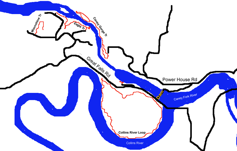
The Collins River meets the larger Caney Fork River north of McMinnville, Tennessee in a deep limestone canyon lined with oaks, hickories and tuliptrees. Just below the confluence sits 92-foot tall Great Falls Dam, built in 1916 by the Tennessee Electric Power Company for power generation, which backs up both the Caney Fork and Collins Rivers to form Great Falls Reservoir, a narrow, 22-mile long lake that has over 1800 acres of surface area. Though the Caney Fork eventually runs to the Cumberland River, which eventually runs to the Tennessee River, the Great Falls Dam is not considered to be within the Tennessee River watershed, and is the only dam administered by the Tennessee Valley Authority that is not within the Tennessee River watershed. The power generators are not located at the dam, but rather are downstream from the dam from which backed-up water is channeled through an underground aquaduct. Just downstream from the dam, water backed up from the Collins River in Great Falls Reservoir seeps through about 500 feet of limestone and falls into the Caney River Gorge below the dam, forming Twin Falls, which is a bit of a misnomer since there are many more than 2 streams of water cascading down, and no two are alike enough to be called Twins. The individual streams of water merge together to form something more like a sheet of a waterfall that stretches for almost a hundred. In fact, the entire cliff that forms the south side of the Caney Fork Gorge leaks water from the reservoir to some degree. It is an impressive sight, especially in winter when every miniscule trickle freezes and becomes very obvious. Looking at a map of how close the Collins River veers to the Caney Fork, it seems inevitable that within a few tens of thousands of years, it will break through the limestone right there at the falls and shorten its path by a couple of miles. Almost immediately below the dam, water reaches the level of Center Hill Lake, the next reservoir along the Caney Fork River, impounded by the massive 260-foot Center Hill Dam some 60 miles downstream. When the powerhouse is generating, massive amounts of water come flying down the gorge, creating whitewater rapids and churning, swirling water smacking rocks and trees. Every time I've been to the powerhouse area, I've encountered kayakers, either in the churning water, or hanging out waiting for the powerhouse to generate so the water level will rise and produce rapids. When the powerhouse is not generating, the gorge is filled only with a shallow trickle of water, and is very peaceful. Rock Island State Park surrounds the Great Falls Dam and the shores of the Caney River immediately below the dam. Apparently the area is named after an actual island that existed at the confluence of the Collins and Caney Fork Rivers but was inundated by Great Falls Reservoir. Its not a large park (883 acres) and the trails are not long or strenuous, but since we live only about 10 minutes away from it, I find myself hiking there pretty often. There are 7 hiking trails in Rock Island State Park, detailed below. The map shows the longer trails only.
Blue Hole Trail
10/29/2010
The trail down the hillside to the river is very steep, and not very well maintained. Starting out, there are some stairs and a wooden rail to help you down over the wet, slick rocks, but that peters out pretty quickly, at which point youre on your own. The trail heads down the same north-facing cliff face that Twin Falls seeps out of, and the same seeping action is evident here, as numerous small seeps and a large waterfall spill out of the rocks and sluice water all down the rocky cliff face under the trees. The rocks are slick with moss, and wobbly too. As I was carrying Ada in the backpack, I was super careful, and all was well. My feet got wet in a hurry, but other than that it was a nice walk down. The spectacle of so much water sliding out of the rockface is really worth the hike. The route is in complete disrepair, and its not clear that there are any plans to spruce it up at all. Its fun, but for most people it might be a bit too wet and wooly. Near water-level, the terrain leveled off and though it was still rocky, it was quicker going. We picked our way along the rocks through the trees to an open rock field on the edge of the water, a deep section of the river where the ripples smooth out and lay still called Blue Hole. Vertical cliffs twenty feet high bordered the south side of the river, with more forest above that. Green vegetation ruled the gorge, and in warmer times, Id be tempted to plop right into the deep water. Ada looked all around at the green trees and blue sky, and really seemed to enjoy the view. From the edge of the water, theres not really anywhere else to go, as the terrain along the river is extremely steep and slippery. Its a short hike, but the destination is a good one.
Caney Fork Gorge Trail Length: 1.6 mile lollipop loop downstream, 0.5 mile trail upstream Difficulty: Easy Trailhead: Follow Powerhouse Rd all the way to the pavement, and park. There are two parking lots to choose from. UTM NAD83 zone16s 623494e 3963556n 1/16/2011
I checked this trail out for the first time in January after a brutal cold snap that left frozen water everywhere. In addition to the snow on the ground and in the trees, every seep from the gorge wall was frozen and silver, creating a winter wonderland. Twin Falls was roaring, sending an anarchy of tumbling water down the cliff and into the river gorge below. The powerhouse was not generating, so there was little water in the gorge, just a light, green trickle heading downstream. Walking downstream along the riverbank, I encountered several kayakers carrying their boats up to the parking area. One of them had a little white dog in a green sweater tagging along. I asked the guy if the dog kayaked with him, and he said yes. Awesome. There is a very well-defined path that hugs the riverbank, and I kept on this path, passing by an offshoot that headed up to the other parking lot. Continuing downstream, I came to Little Falls, a small waterfall that has a cave behind it that you can walk into, and come out on the other side of the falls. Its a neat, short side trip. Blue Hole was the next feature along the trail, a deep calm pool of water in the gorge that is not easily accessible from the north side, but is easy to get to from the Blue Hole Trail. Around this time the trail began a short loop, and at the fork in the trail, I headed right, following the cliff face through thick trees. I passed by an uprooted tuliptree with a mat of thick roots about 8 feet in diameter on display. Having just spent several days measuring girdling roots on young maple trees at work, I took time to examine the way the large roots crossed and fused with each other to make an intricate lattice. The trail began to curve back after a bit, and I noted that a spur trail led down to a small beach along the water, but I didnt head down there. Instead, I continued on the trail as it circled back around and began heading upstream along the top of a 20-foot cliff that plunged vertically into the green water below. Across the river, thousands of icicles exuded from the rockface, and about once every three minutes, a resounding splash echoing through the gorge indicated a large chunk of ice letting go of the rock and crashing into the water below. The loop trail rejoined the main trail at Blue Hole, and from there I simply retraced my steps upstream, and took the shortcut trail to the upper parking lot.
Collins River
Loop
10/16/2010
The trail is very straightforward, being a simple loop around the peninsula that follows the Collins River for about a mile and half before it joins the Caney Fork River just above the dam. Houses and docks dot the far side of the river, but the park side of the river is pristine and calm. The trail is wide enough for two people to walk abreast for almost the entire length. Several members of the Cunningham family are buried just alongside the trail, and the oldest and largest marker of white marble is plainly visible from the path, though I passed by it half a dozen times before noticing it. There are several large black walnuts along the trail near the bridge, and also near the picnic table at the trailhead, which litter the ground with hundreds of tasty nuts in the fall, if you care to take the time to crack them.
Eagle Trail
10/16/2010
Moonshine Trail
2/12/2011
Old Mill Trail
1/30/11
Andra rockhopped down to the green water pooled below, and walked along the edge of the hole, which looked like a fantastic swimming spot, while Ada and I watched from the limestone ledges above. Downstream to the west, the powerhouse was clearly visible, as was Twin Falls. A couple of people were milling about on the rocks on the opposite side of the river near the large warning banner above the powerhouse. It was a nice, quiet spot. Once Andra got the fill of the water-watching, we all marched back upstream on the barren rock of the gorge bottom, and then hiked up through the trees on the slick stairs to the parking lot, and zipped off to do another trail.
|
;)
;)
;)
;)
;)
;)
;)
;)
;)
;)
;)
;)
;)
;)
;)
;)
;)
;)
;)
;)
;)
;)
;)
;)
;)
;)
;)
;)
;)
;)
;)
;)
;)
;)
;)
;)
;)
;)
;)
;)
;)
;)
;)
;)
;)
;)
;)
;)
;)
;)
;)
;)
;)
;)
;)
;)
;)
;)
;)
;)
;)
;)
;)
;)
;)
;)
;)
;)
;)
;)
;)
