Location:
East side of Lake Powell within the Navajo Nation on the Utah-Arizona border
Access: From
Page, AZ take Route 98 east ~50 miles, then head north on Navajo Mt Road
(Route 16). After ~20 miles, the road turns into a hard packed dirt road.
A fork in the road at around mile 30 is labeled by an old sign that says
Navajo Mt Trading Post. Take the left fork. In ~4 miles, take the right
fork just before a 60 ft sandstone knob on the right of the road called
Haystack Rock. You end up in a small clearing with a well that is called
War God Springs. This is as far as a low clearance vehicle can comfortably
go. About 1 mile up the dirt road to the NW lay the ruins of Rainbow Lodge
and the head of the south trail. The dirt road narrows and becomes the
trail, which is very well marked the entire way. There is also a north
trail from Navajo Mt Trading Post, but I dont know much about it.
Maps: USGS
1:24K Quads: Chaiyahi Flat, Rainbow Bridge
Trail: Old
Rainbow Lodge to Rainbow Bridge is listed as 13 miles, with very dramatic
ascents and descents through rugged canyon country. The trail initially
climbs steadily up a root of Navajo Mt, splits and then rejoins a ½
mile later, then drops sharply down to 5920 feet in Horse Canyon, only
to ascend steeply through switchbacks up the next ridge to the north. From
there, the trail heads north uphill for a long time, and one rises up to
a maximum elevation of 6440 feet before topping Yabut Pass into Cliff Canyon.
A long western-facing downhill trek takes you almost 2000 feet down to
the bed of Cliff Creek, where the sheer sandstone cliffs to the south rise
over 2000 feet above, providing the first shade of the hike. The trail
follows Cliff Creek to the NW for about 2.5 miles, and in April of 2003
numerous clear pools of water and sections of vigorously flowing water
were present. The elevation gradually decreases along the way to about
4200 feet before the trail takes an abrupt right turn at Redbud Pass and
climbs out of Cliff Canyon to the north and drops down into Redbud Creek.
Redbud Pass is a very narrow and steep route that rises perhaps 300-400
feet. Traveling from Cliff Canyon to Redbud Creek via the pass looks easier
than going the other direction, due to steep dropoffs on the northern side.
Less than a mile after meeting Redbud Creek, the trail intersects Bridge
Canyon, along with the northerly route from Navajo Mt Trading Post. From
there, the trail continues on only a couple more miles before entering
the monument. Rainbow Bridge is a very short stroll from the SE monument
boundary. Taking time to explore a couple of side canyons, and stopping
often for photographs, we made the hike from Rainbow Lodge to Rainbow Bridge
in two days, hiking about 5 hours/day.
Fees: Trip
permit $10 and camping fee of $2/night through the Navajo Nation; no fee
to enter the National Monument.
Friday April 18, 2003
 The
alarm clock beeped at 6:30 and I got up and showered by way of a nozzle
head that practically required sitting down to get under. Dave was up letting
his dog out when I awoke. We had a quick breakfast of Carens breakfast
burritos and then loaded the car under a clear, blue Colorado sky that
provided a magnificent backdrop for the snow-shrouded heights of Pikes
Peak. We left Colorado Springs behind at around 8:30, driving south down
I-25 through Pueblo in light traffic, while the poor tie-wearing commuters
sentenced to yet another work day drove north to the giant congestive hell
called Denver. I turned the car west at Walsenburg, then engaged the cruise
control on Hwy 160 for the long haul to Arizona. The mountain terrain,
dramatically accented by snowbanks on the relatively treeless slopes, almost
caused our trip to go no further than La Veta Pass where we both wouldve
been pleased to stop and backpack. We had lunch at Subway in Pagosa Springs,
but otherwise kept on the road. We encountered snow on Wolf Creek Pass,
and traffic was backed up due to an apparent tunnel construction project
that had cut the road down to a single lane. Fortunately, we arrived within
a minute or so of our lane getting to go through, so we really didnt have
to wait at all. The skies were fairly grey and threatening from then on,
and we encountered some snow on the ground just east of Page, AZ. The
alarm clock beeped at 6:30 and I got up and showered by way of a nozzle
head that practically required sitting down to get under. Dave was up letting
his dog out when I awoke. We had a quick breakfast of Carens breakfast
burritos and then loaded the car under a clear, blue Colorado sky that
provided a magnificent backdrop for the snow-shrouded heights of Pikes
Peak. We left Colorado Springs behind at around 8:30, driving south down
I-25 through Pueblo in light traffic, while the poor tie-wearing commuters
sentenced to yet another work day drove north to the giant congestive hell
called Denver. I turned the car west at Walsenburg, then engaged the cruise
control on Hwy 160 for the long haul to Arizona. The mountain terrain,
dramatically accented by snowbanks on the relatively treeless slopes, almost
caused our trip to go no further than La Veta Pass where we both wouldve
been pleased to stop and backpack. We had lunch at Subway in Pagosa Springs,
but otherwise kept on the road. We encountered snow on Wolf Creek Pass,
and traffic was backed up due to an apparent tunnel construction project
that had cut the road down to a single lane. Fortunately, we arrived within
a minute or so of our lane getting to go through, so we really didnt have
to wait at all. The skies were fairly grey and threatening from then on,
and we encountered some snow on the ground just east of Page, AZ.
Our destination was Wahweap
Lodge and Marina, on the southern edge of Lake Powell. Outside of Page,
we approached Glen Canyon Dam. Some facts on the dam: 1,560 ft wide
at the crest, 710 ft above bedrock and 583 ft above the original Colorado
River bed. Concrete for the dam was poured around the clock for 3 straight
years, beginning in 1956. At full pool, the lake is 560 ft deep at the
dam (NPS, 2002). My first sight of the dam was a significant moment because
of all I had read about it, mostly from anti-dam critics like Edward Abbey,
David Brower and Katie Lee. I dont pretend to be unbiased, but then again,
anyone who does is still just pretending. I dont think anyone is unbiased
about anything. The images and 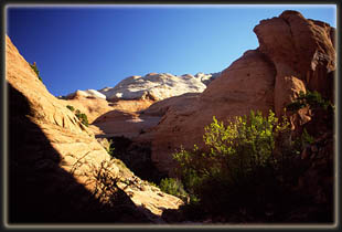 descriptions
of the wondrous beauty of Glen Canyon before the dam paint the immense
concrete and steel structure in a lurid light for me, and while I appreciate
the amazing utility of such a feature, I would have it not there if given
a choice. A trestle bridge spans the canyon just downstream of the dam.
The area is deliciously rugged and orange, with no plants whatsoever. The
only break in the sea of rock comes in the form of the hundreds of power
line towers and wires stretching every which way and off to the distance
like an occupying army. Nothing could look more out of place than
those steel towers. The canyon is very narrow, as good dam sites are apt
to be, and the walls are straight, tall and stained with a thousand streaks
of metal oxides. Looking at the water level above and below the dam gives
an appreciation for the immense holding capacity it has, especially when
one looks at the map and sees the Colorado River backed up over 100 miles
upstream, and into hundreds of side channels. Imagine the pressure on that
concrete. From what I have read, and heard, no other dam has generated
as much controversy as this one, and it was like confronting the villain
of a dream in living color. In my estimate, backed up by some obvious facts,
the dam has created an unnatural reservoir of cooler and clearer than normal
water in a dry area that benefits, of all animals, only non-native species
of fish, upsetting the entire ecosystem of the area, and flooding thousands
of square miles of fragile canyon riparian areas descriptions
of the wondrous beauty of Glen Canyon before the dam paint the immense
concrete and steel structure in a lurid light for me, and while I appreciate
the amazing utility of such a feature, I would have it not there if given
a choice. A trestle bridge spans the canyon just downstream of the dam.
The area is deliciously rugged and orange, with no plants whatsoever. The
only break in the sea of rock comes in the form of the hundreds of power
line towers and wires stretching every which way and off to the distance
like an occupying army. Nothing could look more out of place than
those steel towers. The canyon is very narrow, as good dam sites are apt
to be, and the walls are straight, tall and stained with a thousand streaks
of metal oxides. Looking at the water level above and below the dam gives
an appreciation for the immense holding capacity it has, especially when
one looks at the map and sees the Colorado River backed up over 100 miles
upstream, and into hundreds of side channels. Imagine the pressure on that
concrete. From what I have read, and heard, no other dam has generated
as much controversy as this one, and it was like confronting the villain
of a dream in living color. In my estimate, backed up by some obvious facts,
the dam has created an unnatural reservoir of cooler and clearer than normal
water in a dry area that benefits, of all animals, only non-native species
of fish, upsetting the entire ecosystem of the area, and flooding thousands
of square miles of fragile canyon riparian areas 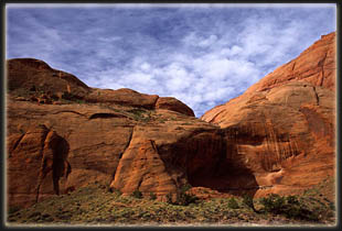 that
took millennia to develop and stabilize. The recreational activities of
the lake are primarily motor-boat related, an activity which spews toxic
emissions, many times worse than those from automobiles, into the air and
results in thousands of gallons of spilled motor fuel and oil into the
water each year. Such boaters all too often discard of their used
comfort items, cups, bottles, cans, plates, forks, couches, etc., into
the lake, so that it has become the American southwests largest garbage
dump. The barren, rock buttes that jut out from the water are completely
lifeless, and the entire area seems sterile. The only touch of green I
saw came from invasive tamarisk patches. I overheard an old southern woman
sum it up best on the last day of our trip by asking her companion, in
typical southern ease, "Wheres all the wildlife? Good question. Answer?
Native wildlife adapted to an intermittent river flow through sandy canyons,
not hundreds of feet of cold water surrounding stone pillars. There is
not much in the way of wildlife in the immediate area of the lake. Its
all been drowned out. I am saddened by the destruction wrought by the dam,
but I am comforted by the thought that the Colorado River can play the
game longer than the dam, and finally, inevitably, crush the concrete into
dust, whereupon the river will flow as it always has, the white slime-stains
of the lake will be scoured from the rocks, the mountains of trash that
lay at the stinking lake bottom will wash into the ocean and the birds,
lizards, snakes, squirrels and insects will once again have a home in the
maze of sandstone canyons. that
took millennia to develop and stabilize. The recreational activities of
the lake are primarily motor-boat related, an activity which spews toxic
emissions, many times worse than those from automobiles, into the air and
results in thousands of gallons of spilled motor fuel and oil into the
water each year. Such boaters all too often discard of their used
comfort items, cups, bottles, cans, plates, forks, couches, etc., into
the lake, so that it has become the American southwests largest garbage
dump. The barren, rock buttes that jut out from the water are completely
lifeless, and the entire area seems sterile. The only touch of green I
saw came from invasive tamarisk patches. I overheard an old southern woman
sum it up best on the last day of our trip by asking her companion, in
typical southern ease, "Wheres all the wildlife? Good question. Answer?
Native wildlife adapted to an intermittent river flow through sandy canyons,
not hundreds of feet of cold water surrounding stone pillars. There is
not much in the way of wildlife in the immediate area of the lake. Its
all been drowned out. I am saddened by the destruction wrought by the dam,
but I am comforted by the thought that the Colorado River can play the
game longer than the dam, and finally, inevitably, crush the concrete into
dust, whereupon the river will flow as it always has, the white slime-stains
of the lake will be scoured from the rocks, the mountains of trash that
lay at the stinking lake bottom will wash into the ocean and the birds,
lizards, snakes, squirrels and insects will once again have a home in the
maze of sandstone canyons.
 After
a spell examining the dam, we drove the car up the road and into the marina
area, paying the $10 Glen Canyon NRA entrance fee and receiving, in return,
a map of Lake Powell. Wahweap Marina straddles the Utah-Arizona border,
and it was here where we planned on staying the first night and picking
up the shuttle the following morning. Turned out that the tent site camping
area was closed, which was, of course, where we planned on camping, so
we had to go up to the RV site. We kept telling ourselves it was only for
a short night, and tried to ignore the gravel surface we had to set up
on, the RV generators switching on and off from all sides, barking dogs,
humming radios and television sets and dozens of security lights. We got
the site, then drove into Page for a quick, cheap Taco Bell dining experience.
While in town, I called the shuttle company and set up a pick up time and
place for the next morning. That set, we drove back to the campground and
went to sleep at dark. After
a spell examining the dam, we drove the car up the road and into the marina
area, paying the $10 Glen Canyon NRA entrance fee and receiving, in return,
a map of Lake Powell. Wahweap Marina straddles the Utah-Arizona border,
and it was here where we planned on staying the first night and picking
up the shuttle the following morning. Turned out that the tent site camping
area was closed, which was, of course, where we planned on camping, so
we had to go up to the RV site. We kept telling ourselves it was only for
a short night, and tried to ignore the gravel surface we had to set up
on, the RV generators switching on and off from all sides, barking dogs,
humming radios and television sets and dozens of security lights. We got
the site, then drove into Page for a quick, cheap Taco Bell dining experience.
While in town, I called the shuttle company and set up a pick up time and
place for the next morning. That set, we drove back to the campground and
went to sleep at dark.
Saturday, April 19
 The
next morning we got up at 6, Arizona time (7 MDT) and quickly packed up
camp and left. We parked at the Wahweap Lodge and began methodically filling
up our packs with backcountry essentials for the next three days: moisture-wicking
socks, sun screen, water bottles, jerky, squeeze cheese, etc. Soon the
packs were full and we were ready to go. Our plan was to hire a shuttle
to ferry us by van to the old Rainbow Lodge on the south side of Navajo
Mt, hike for three days to and around Rainbow Bridge, camp anywhere we
liked, then take one of the twice-daily tour boats from Rainbow Bridge
back to Wahweap Lodge. When we returned to the marina, we would simply
hop in the car and drive off. All nice and neat. I confirmed our
return trip reservation with the boat tour desk at the marina, and we were
all set for the shuttle to pick us up at 7 AM. Seven came and went, and
I used Daves cell to call the driver at 10 after. He was in the wrong
place, or at least, not the place I was told to meet him at. He said
hed be down in a few minutes, and we watched him drive up. We waved at
him, and he drove right past, so I ran after the van and flagged him down.
Dave and I both got nervous right from the start when the driver asked
us if we knew how to get to where we were going. He had no map in the van,
and professed to have never driven anywhere east of Page, which was where
we were going. The few directions I had downloaded from the amazing internet
alluded to unmarked dirt roads and four-wheel drive conditions, so the
fact that he had no idea where he was going, and had picked us up in a
2-wheel drive 15-passenger van, inspired no confidence whatsoever. Dave
and I exchanged sidelong glances of concern as the twitchy driver called
his boss and tried to figure things out. He finally felt comfortable with
where he was going, and we drove away at around 7:30. He had to stop in
Page for gas (another thing I thought was odd..why did he pick us up with
an empty tank?) and to clean the windshield. Finally, we were off. I tried
to quell my growing stress at having a driver who clearly had very little
idea how to get where he was going. The
next morning we got up at 6, Arizona time (7 MDT) and quickly packed up
camp and left. We parked at the Wahweap Lodge and began methodically filling
up our packs with backcountry essentials for the next three days: moisture-wicking
socks, sun screen, water bottles, jerky, squeeze cheese, etc. Soon the
packs were full and we were ready to go. Our plan was to hire a shuttle
to ferry us by van to the old Rainbow Lodge on the south side of Navajo
Mt, hike for three days to and around Rainbow Bridge, camp anywhere we
liked, then take one of the twice-daily tour boats from Rainbow Bridge
back to Wahweap Lodge. When we returned to the marina, we would simply
hop in the car and drive off. All nice and neat. I confirmed our
return trip reservation with the boat tour desk at the marina, and we were
all set for the shuttle to pick us up at 7 AM. Seven came and went, and
I used Daves cell to call the driver at 10 after. He was in the wrong
place, or at least, not the place I was told to meet him at. He said
hed be down in a few minutes, and we watched him drive up. We waved at
him, and he drove right past, so I ran after the van and flagged him down.
Dave and I both got nervous right from the start when the driver asked
us if we knew how to get to where we were going. He had no map in the van,
and professed to have never driven anywhere east of Page, which was where
we were going. The few directions I had downloaded from the amazing internet
alluded to unmarked dirt roads and four-wheel drive conditions, so the
fact that he had no idea where he was going, and had picked us up in a
2-wheel drive 15-passenger van, inspired no confidence whatsoever. Dave
and I exchanged sidelong glances of concern as the twitchy driver called
his boss and tried to figure things out. He finally felt comfortable with
where he was going, and we drove away at around 7:30. He had to stop in
Page for gas (another thing I thought was odd..why did he pick us up with
an empty tank?) and to clean the windshield. Finally, we were off. I tried
to quell my growing stress at having a driver who clearly had very little
idea how to get where he was going.
The weather looked just plain
awful as we drove east, with low hanging clouds and fog all along the horizon.
I tried to keep optimistic about the chances for clearing. We drove north
on Navajo Mountain Road, listening to our driver fret about the road conditions
when it turned into a packed clay road after about 20 miles. My directions
advocated a left turn at the fork marked by the Navajo Mt School sign.
Unfortunately, there was no sign of that type anywhere, and we took a wrong
turn at a fork with a Navajo Mt Trading Post sign. By this time, our driver
had given up trying to follow his own instinct, and was simply asking us
where to go at every turn. We drove for awhile on that road, then decided
it was going the wrong way, and had him 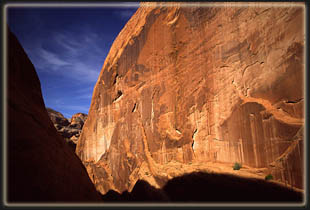 turn
around. Stopped to ask a Navajo on horseback with three dogs directions
and he pointed us in the correct direction. Back on the right road, I told
him to turn right at the sandstone knob. He asked me what a sandstone knob
was. Clearly not a seasoned desert rat. I explained, and between Dave and
I, we managed to get the van to War God Springs, where the road gets very
sketchy. He started jerking his right arm into the air when the road turned
to 4-wheel drive, clearly getting nervous. Im not kidding about the jerking
arm, it was the type of macro-nervous-tic I thought only existed in movies.
After half a mile, we had him stop and told him wed walk from there on,
since the van was moving at a snails pace, and the violent jostling of
the long-bed vehicle was giving me a headache. He gratefully complied,
and we parted ways, paying him the full price for the shuttle despite his
getting
lost and not actually getting us to where we wanted to go. Down the trail
a bit, we stopped to adjust our packs and get things in order, glad to
be out of the van and on our own. A tremendous weight lifted as we
finally reached the part of the trip where we didnt have to rely on shuttles,
campgrounds, gas stations or restaurants. Controlling ones own destiny
is a very satisfying feeling that is hard to come by in this rush-hour
society. The GPS showed us to be but half a mile from the old Rainbow Lodge,
so we felt pretty good overall. turn
around. Stopped to ask a Navajo on horseback with three dogs directions
and he pointed us in the correct direction. Back on the right road, I told
him to turn right at the sandstone knob. He asked me what a sandstone knob
was. Clearly not a seasoned desert rat. I explained, and between Dave and
I, we managed to get the van to War God Springs, where the road gets very
sketchy. He started jerking his right arm into the air when the road turned
to 4-wheel drive, clearly getting nervous. Im not kidding about the jerking
arm, it was the type of macro-nervous-tic I thought only existed in movies.
After half a mile, we had him stop and told him wed walk from there on,
since the van was moving at a snails pace, and the violent jostling of
the long-bed vehicle was giving me a headache. He gratefully complied,
and we parted ways, paying him the full price for the shuttle despite his
getting
lost and not actually getting us to where we wanted to go. Down the trail
a bit, we stopped to adjust our packs and get things in order, glad to
be out of the van and on our own. A tremendous weight lifted as we
finally reached the part of the trip where we didnt have to rely on shuttles,
campgrounds, gas stations or restaurants. Controlling ones own destiny
is a very satisfying feeling that is hard to come by in this rush-hour
society. The GPS showed us to be but half a mile from the old Rainbow Lodge,
so we felt pretty good overall.
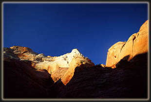
The sun was hidden behind
clouds to the east, but the weather had substantially improved since the
middle of the drive when it looked so bad. I started out with my sweatshirt
on, but pulled it off in about half a mile as the uphill trail warmed me
up quick. The dry desert air was intoxicating. We reached the ruins of
Rainbow Lodge, and noted a white pickup parked under the trees, apparently
belonging to two people whose footsteps we would see along the entire trail
but whose bodies remained hidden. Months ago, I was warned not to park
overnight at this spot in order to avoid automobile vandalism. Whether
that is a serious threat or not, I dont know, but it was a factor in us
deciding to take a shuttle from Wahweap Lodge.
 About
the time we left the old Rainbow Lodge, the sun rose above the clouds that
seemed to hover over Navajo Mt, and it really warmed up. We followed the
well-marked trail through sparse juniper and yucca, some of which were
sending up their annual bloom stalk. The trail split, and we took the lower
trail that switchbacked down into a wash, First Canyon, then turned west
and rose steadily up the next ridge. The silence of the still air was welcome,
and the methodical crunch of gravel underfoot soothed like a good massage.
Old horse droppings littered the trail. For most of this stretch, the view
to the south and west encompassed a vast expanse of canyon country, and
I kept stretching my head around to see it as we veered to the north. Clouds
still enveloped the summit of Navajo Mt, creating a stark contrast between
the snowy, cold peak and the warm, dry canyons. At the top of the
2nd ridge, the two forks of the trail joined again, just in time for a
steep and straight shot down into Horse Canyon, which runs almost directly
east-west. The trail down ran through comforting pockets of shade, although
the steepness of the dropoff literally caused me to get dizzy while looking
down. At the bottom of the draw, I wondered how in the world we would get
out since the opposing wall was so steep. Looks can be deceiving from below
a hill, Dave pointed out, and this one was no different, as we zig-zagged
up in a lot less time than I thought it would take. At the top, we shed
our packs and took a break. Amazingly, Daves cell phone was getting a
signal, so we called Matt, who almost made this trip with us, at home on
Long Island to say hello. I also called Andra and left a message on her
machine since she was still in southern California on her own little trip. About
the time we left the old Rainbow Lodge, the sun rose above the clouds that
seemed to hover over Navajo Mt, and it really warmed up. We followed the
well-marked trail through sparse juniper and yucca, some of which were
sending up their annual bloom stalk. The trail split, and we took the lower
trail that switchbacked down into a wash, First Canyon, then turned west
and rose steadily up the next ridge. The silence of the still air was welcome,
and the methodical crunch of gravel underfoot soothed like a good massage.
Old horse droppings littered the trail. For most of this stretch, the view
to the south and west encompassed a vast expanse of canyon country, and
I kept stretching my head around to see it as we veered to the north. Clouds
still enveloped the summit of Navajo Mt, creating a stark contrast between
the snowy, cold peak and the warm, dry canyons. At the top of the
2nd ridge, the two forks of the trail joined again, just in time for a
steep and straight shot down into Horse Canyon, which runs almost directly
east-west. The trail down ran through comforting pockets of shade, although
the steepness of the dropoff literally caused me to get dizzy while looking
down. At the bottom of the draw, I wondered how in the world we would get
out since the opposing wall was so steep. Looks can be deceiving from below
a hill, Dave pointed out, and this one was no different, as we zig-zagged
up in a lot less time than I thought it would take. At the top, we shed
our packs and took a break. Amazingly, Daves cell phone was getting a
signal, so we called Matt, who almost made this trip with us, at home on
Long Island to say hello. I also called Andra and left a message on her
machine since she was still in southern California on her own little trip.
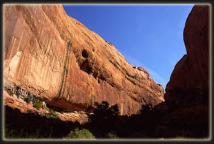
Continuing on, the trail
just went higher, though I expected it to start descending. Up and up we
went, with an increasingly breathtaking view opening up to the west all
the time, and the crack of Dome Canyon yawning over a thousand feet below.
Beyond that, a sea of sandstone boiled in curves, twists and fingers, completely
obscuring any routes or passes through this land. Miles away on the horizon,
massive cliffs of the Kaiparowits Plateau rose up several thousand feet
above. I spent lots of time stopping all along the trail, and while in
subsequent camps, to take photographs. Since I had my tripod, a fully manual
camera, two lenses and two filters, setup times often lasted several minutes.
Im sure Dave got bored waiting on me, but I bribed him off by promising
to send him a CD with all the slide scans from the trip in a month or two,
so all should be well. He brought his small APS camera, but forgot to bring
film, therefore, my photographs should be of interest to him. The sky cleared
above Navajo Mt, but we were too close to see the actual summit. Before
long, we approached Yabut Pass over the massive rock wall that separates
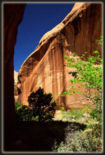
Dome Canyon from Cliff Canyon, and stopped in the shadow cast by the wall
on the Cliff Canyon side. There we ate an impromptu lunch of cheese, crackers
and jerky, washed down with Fruit Punch Gatorade. Fine dining in canyon
country. An inscription on the wall said something about suffering. We
hoped it wasnt a prediction of things to come. The drop down into Cliff
Canyon was a long, steep drop of almost 2000 feet that brought blisters
to my feet and shakes to my thighs. Lizards darted to and fro in the rocks
on the sides of the trail, appearing and disappearing like Halloween tricksters.
I scratched my legs on the abundant bitterbrush. We stopped in the cool
shade of the canyon bottom for another break, and I took some ibuprofen
for my headache that was causing blood to pound in my skull with each step.
We looked around in the creek
for water, and found none, making us a little nervous. I had brought a
gallon, and so had Dave, but that wouldnt last us two days so we had to
find water somewhere. We continued on, mostly in the shade, along a gentle,
sand trail that had few obstacles. From that point on, the tough hiking
was 95% done with, and we reveled in the soft, flat trail by Cliff Creek.
It had taken us almost 4 hours to get to Cliff Creek, so we basically decided
to plop down at the 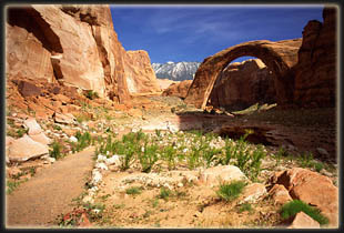 first
good spot we found. There was a lot more vegetation in the canyon
than I had expected, thinking it would be something like the Needles District
at Canyonlands. It was not. Willow and juniper provided a relatively dense
canopy in spots, while the ground was covered with prickly pear, blooming
red penstemon, sharp yucca and soft clumps of new Indian Rice Grass and
Cheatgrass. A few puddles came into view, and we grew hopeful. We passed
them by, and soon there were regular pools of water, some looking more
tasty than others. The first spot we checked would have been perfect
a nice flat sandy ledge above the creek with water nearby had it not
been for the incredibly robust prickly pear population. We found a few
small flat spots that were cactus-free, but neither of us was thrilled
with the spot. We left our gear there and explored downstream and found
a great spot that was open, sandy, cactus-free and near water. So, back
up to get our stuff, down canyon once again about 100 yards. There we relaxed,
pulled off our boots and sat in the shade sipping Gatorade. I should try
to describe this campsite, but a picture will do better. It was all
fine and well, but soon we became restless and decided to go exploring. first
good spot we found. There was a lot more vegetation in the canyon
than I had expected, thinking it would be something like the Needles District
at Canyonlands. It was not. Willow and juniper provided a relatively dense
canopy in spots, while the ground was covered with prickly pear, blooming
red penstemon, sharp yucca and soft clumps of new Indian Rice Grass and
Cheatgrass. A few puddles came into view, and we grew hopeful. We passed
them by, and soon there were regular pools of water, some looking more
tasty than others. The first spot we checked would have been perfect
a nice flat sandy ledge above the creek with water nearby had it not
been for the incredibly robust prickly pear population. We found a few
small flat spots that were cactus-free, but neither of us was thrilled
with the spot. We left our gear there and explored downstream and found
a great spot that was open, sandy, cactus-free and near water. So, back
up to get our stuff, down canyon once again about 100 yards. There we relaxed,
pulled off our boots and sat in the shade sipping Gatorade. I should try
to describe this campsite, but a picture will do better. It was all
fine and well, but soon we became restless and decided to go exploring.
Because of the winding nature
of the canyon, one couldnt see down- or up-canyon very far at all. Numerous
fins overlapped to block the view. Between each of these fins was a side
canyon just waiting to be explored. We happened to have a deep looking
side canyon just to the north of our camp, so we walked up there right
away. First we crossed a gentle slope of 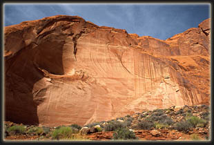 grass,
yucca and juniper that led out of the warm sunlight into the cool shade,
then we hit a solid sandstone slope and walked quietly uphill. A sandy
strip with grass and redbud lay between two opposing planes of rock. The
purple blossoms of the redbud sweetened the air. The draw grew thinner,
and steeper, and soon it was a matter of strict concentration to avoid
slipping all the way to the bottom of the giant V we were now traversing.
I appreciated the grip of my lug-soled boots. The walls stretched a couple
hundred feet above, blocking out almost all light. As the walls drew closer,
the dark shade cooled the air even more. Along one wall, a long, horizontal
seep had created a profuse hanging garden of maiden hair fern, moss, and
a few other plants that Id never seen before, perhaps being too rare to
put in field guides. The walls became steep enough to necessitate the use
of both hands, so I had to cache my tripod and take along just the camera
on my back. With feet on one wall, and hands pressing against the other,
we managed to make grass,
yucca and juniper that led out of the warm sunlight into the cool shade,
then we hit a solid sandstone slope and walked quietly uphill. A sandy
strip with grass and redbud lay between two opposing planes of rock. The
purple blossoms of the redbud sweetened the air. The draw grew thinner,
and steeper, and soon it was a matter of strict concentration to avoid
slipping all the way to the bottom of the giant V we were now traversing.
I appreciated the grip of my lug-soled boots. The walls stretched a couple
hundred feet above, blocking out almost all light. As the walls drew closer,
the dark shade cooled the air even more. Along one wall, a long, horizontal
seep had created a profuse hanging garden of maiden hair fern, moss, and
a few other plants that Id never seen before, perhaps being too rare to
put in field guides. The walls became steep enough to necessitate the use
of both hands, so I had to cache my tripod and take along just the camera
on my back. With feet on one wall, and hands pressing against the other,
we managed to make 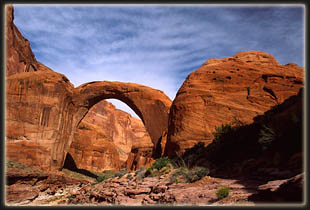 it
past a particularly steep spot that opened up beyond into a less steep
area that was quiet, dark and very lush with riparian species living off
the slow seeping water pressing through the crack in the wall. There
the path ended, as the far side was way too steep for anybody to manage.
The box end foiled us, and we turned back, but not disappointed by any
stretch. In fact, this little side canyon exploration was my personal favorite
moment of the trip. From the high point on our way out we could look across
Cliff Creek to the other promising chutes and draws and see that they led
nowhere in a big hurry. Dave had opted out of his hiking boots for this
little trip, but paid for that choice by stabbing his toe on a yucca leaf
that quickly embedded itself under the skin, and required minor surgery
with a needle to remove back at camp. We walked down canyon to the next
draw and began climbing up toward it, but before we got very far, we could
see it was too steep to try, and we went back to camp. it
past a particularly steep spot that opened up beyond into a less steep
area that was quiet, dark and very lush with riparian species living off
the slow seeping water pressing through the crack in the wall. There
the path ended, as the far side was way too steep for anybody to manage.
The box end foiled us, and we turned back, but not disappointed by any
stretch. In fact, this little side canyon exploration was my personal favorite
moment of the trip. From the high point on our way out we could look across
Cliff Creek to the other promising chutes and draws and see that they led
nowhere in a big hurry. Dave had opted out of his hiking boots for this
little trip, but paid for that choice by stabbing his toe on a yucca leaf
that quickly embedded itself under the skin, and required minor surgery
with a needle to remove back at camp. We walked down canyon to the next
draw and began climbing up toward it, but before we got very far, we could
see it was too steep to try, and we went back to camp.
We filtered water from one
of the large, still pools in the creek bed, then cooked dinner of 3 cheese
rotini and complemented that with jerky. Nothing but the best. Dave ceremoniously
devoured his Twix bar, carefully preserved for just this moment. I 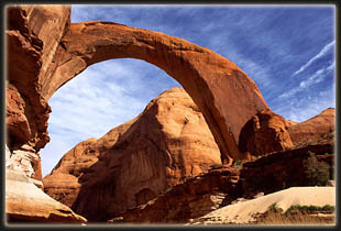 decided
to save mine for the following night. We arranged our sleeping pads
out in the open on a flat sand patch, hidden from the trail by a series
of very large black rocks. I strolled around looking at plants and rocks,
and while jumping from a high rock to the sand below rammed my knee into
a yucca plant that immediately drew blood which soaked through the thin
quick-drying fabric of my pants. Those darn things are pretty vicious.
I noted that many yucca along the way had been browsed and I found it hard
to believe that any animal could find such tough fibrous leaves palatable. decided
to save mine for the following night. We arranged our sleeping pads
out in the open on a flat sand patch, hidden from the trail by a series
of very large black rocks. I strolled around looking at plants and rocks,
and while jumping from a high rock to the sand below rammed my knee into
a yucca plant that immediately drew blood which soaked through the thin
quick-drying fabric of my pants. Those darn things are pretty vicious.
I noted that many yucca along the way had been browsed and I found it hard
to believe that any animal could find such tough fibrous leaves palatable.
As the sun set, the shadows
in the canyon became cool, and by dark it was fairly chilly. The stars
came out in a crystal clear sky, and I attempted evening star shots as
Dave drifted off to sleep. We were talking most of the evening, and then
suddenly, Dave stopped answering. I shut up and took more pictures. Frogs
croaked like mechanical sheep down the canyon, suggesting more abundant
water in that direction. Despite the pools of water, insects were pretty
scarce. I took a few shots around 9 PM, but felt too tired to stay up any
later bothering with that. I laid the tripod down on the ground, and put
my camera away. An owl made his presence known somewhere nearby. I fell
asleep very quickly, waking up in the middle when Dave, who was sleeping
about 8 feet away, poked me with my camera tripod trying to get me to stop
snoring.
Sunday, April 20
It was a chilly night, and
I slept with my head buried inside the bag. Several times I poked my head
out of the bag to watch the stars, in their unpolluted clarity, for a few
seconds before going back to sleep. As morning approached, birds began 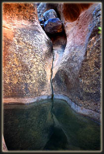 singing,
and the bright light of dawn hurt my eyes. When I finally got up around
6:30, the outside of my bag was soaked with dew. The entire canyon was
in shadow, but I could see a single sliver of golden sandstone far off
down the canyon where the sun was shining. The sky was cloudless. In the
chilly morning air, I got dressed as Dave woke up. Due to the wet bags,
we decided to wait until the sun was in camp to dry things out before leaving,
contrary to the original plan of getting to the bridge as soon as we could.
Therefore, I walked down the canyon to see if there were any good morning
photographic opportunities. Very shortly on my walk downstream I came upon
running water, coming from some unseen spring in one of the numerous side
chutes winding up and out of sight on both sides of the singing,
and the bright light of dawn hurt my eyes. When I finally got up around
6:30, the outside of my bag was soaked with dew. The entire canyon was
in shadow, but I could see a single sliver of golden sandstone far off
down the canyon where the sun was shining. The sky was cloudless. In the
chilly morning air, I got dressed as Dave woke up. Due to the wet bags,
we decided to wait until the sun was in camp to dry things out before leaving,
contrary to the original plan of getting to the bridge as soon as we could.
Therefore, I walked down the canyon to see if there were any good morning
photographic opportunities. Very shortly on my walk downstream I came upon
running water, coming from some unseen spring in one of the numerous side
chutes winding up and out of sight on both sides of the 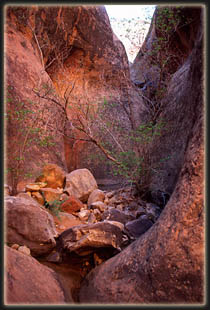 creek.
This has been described as a permanent spring called First Water by numerous
authors, and has a couple of well-used campsites nearby. The running water
provided suitable habitat for cat tails, Equisetum and tall reedy grasses,
in addition to redbuds, box elders and willows. Some of the healthiest
Ephedra plants Ive ever seen reside here. In the jungle-like canyon bottom,
I bulled my way down the narrow, overgrown trail, where off to the left
sat a wooden outhouse, seeming very out of place in this completely remote
area, but confirming that this area has historically been an overnight
stop for hikers and packers. An occasional mosquito buzzed in my
face, but the bugs were surprisingly and pleasantly few. A little further
down I found a side canyon that looked shallow enough for my boots to grip,
and walked up. Halfway, the pitch steepened, and I cached my camera on
a ledge so I could use both my hands. I didnt go more than 50 or 60 feet
up before I reached a dome that hung out over the creek. Hoping I could
see camp from there, I got to the top, but the view up canyon was blocked
by an intervening fin. I slowly scooted down and returned to camp. creek.
This has been described as a permanent spring called First Water by numerous
authors, and has a couple of well-used campsites nearby. The running water
provided suitable habitat for cat tails, Equisetum and tall reedy grasses,
in addition to redbuds, box elders and willows. Some of the healthiest
Ephedra plants Ive ever seen reside here. In the jungle-like canyon bottom,
I bulled my way down the narrow, overgrown trail, where off to the left
sat a wooden outhouse, seeming very out of place in this completely remote
area, but confirming that this area has historically been an overnight
stop for hikers and packers. An occasional mosquito buzzed in my
face, but the bugs were surprisingly and pleasantly few. A little further
down I found a side canyon that looked shallow enough for my boots to grip,
and walked up. Halfway, the pitch steepened, and I cached my camera on
a ledge so I could use both my hands. I didnt go more than 50 or 60 feet
up before I reached a dome that hung out over the creek. Hoping I could
see camp from there, I got to the top, but the view up canyon was blocked
by an intervening fin. I slowly scooted down and returned to camp.
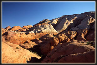
Upon my return, we discussed
the timing of the day, and decided that since the sun had not yet even
touched the top of the canyon walls, a considerable delay would be inevitable
should we continue to wait for the sun to dry things out prior to leaving.
We decided to leave, and dry bags out later. We quickly packed up camp
and took off. As we approached the side chute on the right of the canyon
that I had earlier ascended, I pointed out a much more robust side canyon
on the opposite 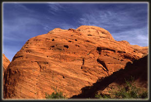 wall
that looked worth exploring. Dave agreed. We shed our packs right next
to the trail and took off up the steep, grassy slope that led up like a
stairway between two unscalable rock walls. The shadow-cloaked slope was
very steep, and we dodged the yucca and cactus on our separate routes up.
Giant angular choke stones, calved from the towering walls above perhaps
before men walked on two legs, provided soil anchors that kept the entire
canyon from being a smooth rock wash. Sweet-smelling redbud provided the
most difficult obstacle to getting up as I bent and wormed my way under
their low-hanging limbs. After several hundred feet, the canyon forked,
and we took the smaller, narrower left fork into a short box canyon that
ended in an abrupt wall. The entrance to this canyon was no more than 6
feet wide, but opened up inside to about 15 feet. An overhanging spout,
stained by metal oxides from centuries of intermittent water flow, hung
directly over a perfectly smooth sandstone bowl filled with cold, dark
water. The round pool was about 10 feet in diameter, hidden like a treasure
in this indistinct and small cove. A side canyon of a side canyon of a
side wall
that looked worth exploring. Dave agreed. We shed our packs right next
to the trail and took off up the steep, grassy slope that led up like a
stairway between two unscalable rock walls. The shadow-cloaked slope was
very steep, and we dodged the yucca and cactus on our separate routes up.
Giant angular choke stones, calved from the towering walls above perhaps
before men walked on two legs, provided soil anchors that kept the entire
canyon from being a smooth rock wash. Sweet-smelling redbud provided the
most difficult obstacle to getting up as I bent and wormed my way under
their low-hanging limbs. After several hundred feet, the canyon forked,
and we took the smaller, narrower left fork into a short box canyon that
ended in an abrupt wall. The entrance to this canyon was no more than 6
feet wide, but opened up inside to about 15 feet. An overhanging spout,
stained by metal oxides from centuries of intermittent water flow, hung
directly over a perfectly smooth sandstone bowl filled with cold, dark
water. The round pool was about 10 feet in diameter, hidden like a treasure
in this indistinct and small cove. A side canyon of a side canyon of a
side 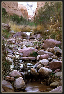 canyon
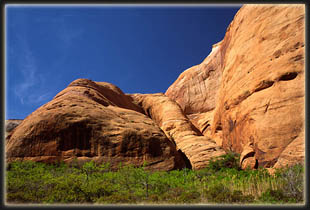
of Glen Canyon. We backed out of the narrow opening, and continued on up
the main drainage. We reached a spot after several hundred more feet where
the slope converged with the left wall so that we could walk out on top
of a huge sandstone dome. Far from being smooth, the surface of this dome
was covered with tiny 1mm spikes that pricked my ass as I sat down.
From the vantage point, we could look down and see our starting point by
the Cliff Creek, as well as ascertain that if time allowed, we could continue
on up the side canyon indefinitely, perhaps all the way to the top of the
towering cliffs at the top of the horizon. Time, unfortunately, did not
allow such an excursion. Perhaps another day. With so many places to see
in this world, and only 60 walking years to see it in (if one is lucky),
I think the chances that I will go back to visit that particular side canyon
in that remote corner of Lake Powell are slim to canyon
of Glen Canyon. We backed out of the narrow opening, and continued on up
the main drainage. We reached a spot after several hundred more feet where
the slope converged with the left wall so that we could walk out on top
of a huge sandstone dome. Far from being smooth, the surface of this dome
was covered with tiny 1mm spikes that pricked my ass as I sat down.
From the vantage point, we could look down and see our starting point by
the Cliff Creek, as well as ascertain that if time allowed, we could continue
on up the side canyon indefinitely, perhaps all the way to the top of the
towering cliffs at the top of the horizon. Time, unfortunately, did not
allow such an excursion. Perhaps another day. With so many places to see
in this world, and only 60 walking years to see it in (if one is lucky),
I think the chances that I will go back to visit that particular side canyon
in that remote corner of Lake Powell are slim to 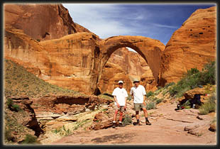 none.
Such a sentiment compels me to take as many photographs and notes as I
can on each place I visit, since I know I will visit few of them a second
time. So many canyons. So little time. none.
Such a sentiment compels me to take as many photographs and notes as I
can on each place I visit, since I know I will visit few of them a second
time. So many canyons. So little time.
The trip back down the side
canyon took very little time, and before we could turn around, we were
back at the creek, chugging water and having a snack. After hiking
another ½ mile or so, we stopped again to filter water from Cliff
Creek before leaving it to cross Redbud Pass. The water in Cliff Creek
was tasty, and plentiful, but we didnt know what to expect in Bridge Creek.
We also took the time to apply sun screen. Dave, who comes from upstate
NY, and hadnt seen the sun in 10 months, burned his legs and elbows by
not applying sun screen to those spots the previous day. I escaped such
a fate, but had terrible blisters on my feet which he seemed immune to.
We skinned an orange and downed it, then continued on 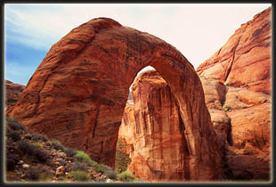 under
a perfect, and I mean perfect, blue desert sky. I dont know if its the
contrast between the orange rock and blue sky, or whether the dry air makes
colors more vibrant, but Ive just never seen such a blue sky anywhere
but in canyon country. under
a perfect, and I mean perfect, blue desert sky. I dont know if its the
contrast between the orange rock and blue sky, or whether the dry air makes
colors more vibrant, but Ive just never seen such a blue sky anywhere
but in canyon country.
Near Redbud Pass, we noted
an old wooden shelter shaped like a teepee. Perhaps part of the Rainbow
Lodge accommodations from the 1950s? Who knows? There are no informational
placards out here, and it is good to have some mysteries left unsolved.
As we turned right into Redbud Pass, Cliff Canyon continued on and out
of sight around a right bend, quietly beckoning us to explore its lonely
depths. Again, we had no time to do so. Redbud Pass still confounds me
with its steepness. Looking at a highly detailed 7.5 quad map, I cant
count more than 2 contour lines (at 40 feet each) that must be crossed
to reach the top of Redbud Pass, yet the elevation gain is several hundred
feet, at least. Probably the most dramatic narrow-canyon section of the
entire route is that through Redbud Pass, where two massive, near-vertical
walls frame a trail in places just wide enough to lead a horse through.
The steepness is compounded by the loose sand trail, which makes it hard
to get a good footing. The pass is aptly named, as hundreds of redbuds
line the thin corridor. The sweet 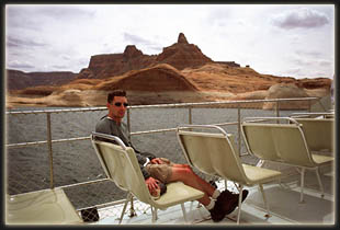 smell
of their tiny purple blossoms freshened the air beyond description. Other
flowers lent color to the pass. Indian paintbrush bloomed red in profusion,
and I saw a single claretcup cactus in full bloom, its blood-red petals
standing out like neon against the shadows of the juniper trees.
The sandy flats where the soil was deeper were covered with prairie wild
onions, their numerous blooms appearing almost like purple and white striped
ribbon candy, and there was no mistaking their pungent aroma. One could
tell the trail was not well traveled since grass and lupine grew right
in the middle of the path. smell
of their tiny purple blossoms freshened the air beyond description. Other
flowers lent color to the pass. Indian paintbrush bloomed red in profusion,
and I saw a single claretcup cactus in full bloom, its blood-red petals
standing out like neon against the shadows of the juniper trees.
The sandy flats where the soil was deeper were covered with prairie wild
onions, their numerous blooms appearing almost like purple and white striped
ribbon candy, and there was no mistaking their pungent aroma. One could
tell the trail was not well traveled since grass and lupine grew right
in the middle of the path.
By the top of Redbud Pass,
marked by a wooden sign held up by a rock pile, my feet were in agony from
blisters that had developed and intensified on my toes and the ball of
each foot. I removed shoes to inspect the damage, found several 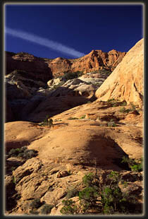 blisters
already ruptured, and decided there was little I could do but try to ignore
the stinging. The way down Redbud Pass, toward Redbud Creek, was much more
rugged than the way up. I had read that someone spent a lot of time trying
to improve the trail with dynamite and shovel work back in the 1920s to
make it passable to pack animals. If at one time horses could descend this
route, they would surely not be able to now. Several 6-9 foot drop-offs
required cautious descents with all four limbs. We began to appreciate
even more the one-way design of our trip. We slowly picked our way down
a boulder field between the two rock walls, and I wondered if we had somehow
lost the trail. No other conceivable route existed, however, so we continued
down at a snails pace, cautiously testing each step to make sure each
rock wouldnt bound down the hill with one of us on it. As the terrain
leveled, the distinct outline of the trail returned, and we were able to
once again walk in comfort. The trail remained a track through a crack
in the rock, almost like a tunnel, and truly a tunnel as it wound between
a vertical rock wall on the left, and vigorous white oak thickets on the
right that covered the trail from above. Flecks of sunlight scattered on
the soft sand of the trail, and the cool shadows felt very refreshing.
The temperature was rising as we were descending towards the river, or
what is now the lake, and we were both sure to keep drinking plenty of
fluids to fend off any uncomfortable side effects of dehydration. blisters
already ruptured, and decided there was little I could do but try to ignore
the stinging. The way down Redbud Pass, toward Redbud Creek, was much more
rugged than the way up. I had read that someone spent a lot of time trying
to improve the trail with dynamite and shovel work back in the 1920s to
make it passable to pack animals. If at one time horses could descend this
route, they would surely not be able to now. Several 6-9 foot drop-offs
required cautious descents with all four limbs. We began to appreciate
even more the one-way design of our trip. We slowly picked our way down
a boulder field between the two rock walls, and I wondered if we had somehow
lost the trail. No other conceivable route existed, however, so we continued
down at a snails pace, cautiously testing each step to make sure each
rock wouldnt bound down the hill with one of us on it. As the terrain
leveled, the distinct outline of the trail returned, and we were able to
once again walk in comfort. The trail remained a track through a crack
in the rock, almost like a tunnel, and truly a tunnel as it wound between
a vertical rock wall on the left, and vigorous white oak thickets on the
right that covered the trail from above. Flecks of sunlight scattered on
the soft sand of the trail, and the cool shadows felt very refreshing.
The temperature was rising as we were descending towards the river, or
what is now the lake, and we were both sure to keep drinking plenty of
fluids to fend off any uncomfortable side effects of dehydration.
 Redbud
Pass drops hikers into Redbud Creek, which has a spectacular canyon of
its own. I dont recall looking up-canyon, but that probably would be a
great place to go explore. Once again, if I ever come back
. Hardly a stones
throw from where the trail intersects Redbud Creek, Redbud Creek intersects
Bridge Creek in Bridge Canyon, and the trail from Navajo Mt Trading Post,
which was the original trail to Rainbow Bridge established in the teens
after the white-man discovery of Rainbow Bridge in 1909. This was
the real sign that we were getting very close. Bridge Canyon was much wider
than Cliff Canyon, and seemed to have taller walls, although I think this
may just be a consequence of having fewer side canyons and corresponding
ridges. The walls were mostly sheer and vertical, with numerous giant overhangs
that sheltered inviting campsites. Bridge Creek ran with more volume,
although we found out later the taste of the water was definitely inferior
to Cliff Creek, for whatever reason. Redbud
Pass drops hikers into Redbud Creek, which has a spectacular canyon of
its own. I dont recall looking up-canyon, but that probably would be a
great place to go explore. Once again, if I ever come back
. Hardly a stones
throw from where the trail intersects Redbud Creek, Redbud Creek intersects
Bridge Creek in Bridge Canyon, and the trail from Navajo Mt Trading Post,
which was the original trail to Rainbow Bridge established in the teens
after the white-man discovery of Rainbow Bridge in 1909. This was
the real sign that we were getting very close. Bridge Canyon was much wider
than Cliff Canyon, and seemed to have taller walls, although I think this
may just be a consequence of having fewer side canyons and corresponding
ridges. The walls were mostly sheer and vertical, with numerous giant overhangs
that sheltered inviting campsites. Bridge Creek ran with more volume,
although we found out later the taste of the water was definitely inferior
to Cliff Creek, for whatever reason.
 The
temperature approached the mid seventies, and we stopped for a break at
a bend in the creek. I ate some cheese and crackers and aired out my boots.
The down-canyon breeze in the shade almost made it feel cold, so both Dave
and I oscillated between sitting in the warm sun, and the cool shade. I
pulled out a map and pondered the possibilities. Rainbow Bridge lies in
the middle of its own small, square National Monument covering 160 acres,
or about 2/3 square mile. No camping is allowed within the monument, but
since that was what we came to see, we wanted to camp as close to it as
possible while staying on Reservation land. The
temperature approached the mid seventies, and we stopped for a break at
a bend in the creek. I ate some cheese and crackers and aired out my boots.
The down-canyon breeze in the shade almost made it feel cold, so both Dave
and I oscillated between sitting in the warm sun, and the cool shade. I
pulled out a map and pondered the possibilities. Rainbow Bridge lies in
the middle of its own small, square National Monument covering 160 acres,
or about 2/3 square mile. No camping is allowed within the monument, but
since that was what we came to see, we wanted to camp as close to it as
possible while staying on Reservation land.
Conversation turned to our
plans for camping on the road after the boat picked us up and dropped us
off at Wahweap Lodge the next afternoon. Since camping along the road is
forbidden inside the reservation, and since it takes at least 2 hours to
drive to Mexican Hat, the first town outside of the reservation on the
way back east, we decided that the afternoon boat would come too late for
us to do anything but camp once again at Wahwap Marina. Neither of us wanted
to do that again. Therefore, we decided that seeing the bridge for the
next 12 hours was enough, and we would attempt to take the morning  tour
boat back to Wahweap, arrive there by 3 and hopefully get to open BLM land
(and free camping) north of Mexican Hat by dark. tour
boat back to Wahweap, arrive there by 3 and hopefully get to open BLM land
(and free camping) north of Mexican Hat by dark.
We put our packs back on
and continued, knowing we were close, and keeping our eyes open for possible
campsites. Several appeared, and we made mental notes. Since it was very
tough to say where the boundary was, the plan evolved into hike to the
boundary, then turn around and camp in the first good spot. We followed
the trail until it started to climb steeply away from the creek. Figuring
we were close to the bridge, we decided that the trail must eventually
meet the creek, and followed a well-defined trail down to the creek and
followed it. The creek bed was solid rock for a spell, and a spout fell
into a deep pool of greenish water that was at least 6 feet deep and ran
in a channel for about 30 feet, being about 10 feet wide. If it were a
hot summer day I wouldve hopped right in, but the water wouldve been
far too cold for that while we were there. The creek bed drew narrower,
and the walls steeper, until we could go no further, and realized the futility
of our effort to hug the creek. We figured the trail was up above somewhere,
and that if we climbed far enough, wed reach it. It is amazing how fast
we descended so far below the trail, for while we were walking downhill,
it was leading steeply uphill. The result was that we had to climb over
a hundred feet of treacherous 60-70 degree slope to get back on the trail.
While resting at the top after the arduous climb up, Dave studied the map,
and determined that we would not be able to get down to the creek until
well 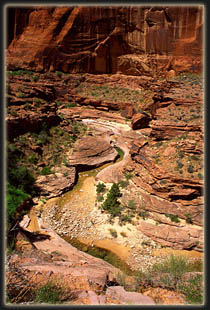 inside
the monument, and since camping hinged on good water, we turned back to
the previously sited spot that had ample water and good tent sites. We
set down our packs for the day at 12, about 5 hours after starting out
from camp that morning. inside
the monument, and since camping hinged on good water, we turned back to
the previously sited spot that had ample water and good tent sites. We
set down our packs for the day at 12, about 5 hours after starting out
from camp that morning.
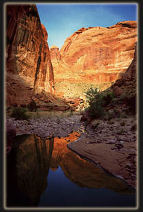
This campsite was marvelous.
Giant planks of flat, though rippled, rock (and I dont think it was sandstone)
formed a multi-leveled platform that overlooked a large, waist-deep pool
of crystal clear water that had water rushing both in and out, filling
and emptying simultaneously, in perpetuity. A sandy beach provided a perfect
tent site, after Dave excavated a giant rock from the middle, while the
flat rocks provided perfect sitting and cooking areas. The rocks above
the pool provided a perfect seat to sit and soak tired, hot feet in the
cold water, which we did as soon as we arrived. We pulled out our wet sleeping
bags and dried them in minutes under the mid day sun. I doctored my blisters
by lancing them and applying bandages while Dave tended to his severely
burned legs. Within an hour of staking our claim, we put a couple of water
bottles in a bag and took off up the trail (not detouring by the creek
this time). We passed through a dilapidated barbed-wire gate, then followed
a flat trail around a deep and thin wash. At the source of this wash lay
the old tourist camp, Echo Camp, 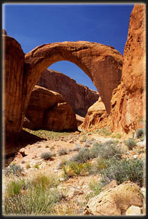 complete
with rusting bed frames and cottage foundations. It was all fenced off,
perhaps for archeological and historical reasons. It didnt look like an
inviting place to explore anyway so we werent disappointed to be herded
along by the obstacles. I was much happier with our open camp than I wouldve
been in this overgrown alcove. complete
with rusting bed frames and cottage foundations. It was all fenced off,
perhaps for archeological and historical reasons. It didnt look like an
inviting place to explore anyway so we werent disappointed to be herded
along by the obstacles. I was much happier with our open camp than I wouldve
been in this overgrown alcove.
The trail stayed pretty flat
as it side-hilled around the slopes and gulleys, weaving left and right
between side-rails of rocks, laboriously stacked along both sides. The
open, flat areas to the right of the trail harbored an abundance of plant
life. Delicate white evening primrose and fading Utah daisies were the
most abundant, but individual desert trumpets and scattered blooming fishhook
cactus provided more color. Once again, I was impressed by the diversity
and abundance of plant life in the thin strip of green along the canyon
bottom. While the trail stayed more or less level, the creek bed, fell
more sharply away, and soon was clearly inaccessible without climbing gear.
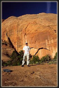
I was walking in front on the trail, and Dave caught first sight of part
of Rainbow Bridge off down the canyon and pointed it out. It was much closer
to the monument boundary 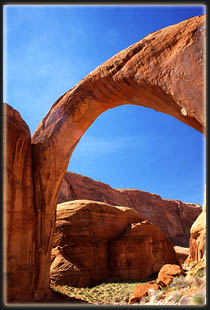 than
I had expected, but there it was, a tremendous arch that appeared tiny
against the enormous canyon walls and buttes rising around it. than
I had expected, but there it was, a tremendous arch that appeared tiny
against the enormous canyon walls and buttes rising around it.
In the American Southwest,
you will find a concentration of sandstone formations that are called arches,
windows or bridges. The designation depends on their method of formation.
Millions of words have been written about the geology of the American Southwest,
so I wont delve into that too much here. Put simply, water erodes the
6 ancient sandstone layers differentially, forming winding waterways that
get deeper with time. In between each waterway segment there develops,
by default, an increasingly tall ridge that gets narrower as the water
cuts a deeper draw. The outer layer of a sandstone fin is often the
strongest, and the inner section of the fin sometimes simply drops away,
creating an arch. Sometimes, quirks of wind dynamics cause a hole to be
sand-blasted into a fin, creating a window. Other times, a creek
will simply wear away at a spot on the base of a fin until it breaks through,
creating a bridge (since it spans water). In all cases, an initially small
opening is then worn wider and wider with time and smooths out to form
delicate and graceful shapes and curves. Rainbow Bridge spans Bridge Creek,
and is the largest natural bridge in the world, with a maximum height from
creek bed to the highest point of the arch of 291 feet, and a maximum inner
width of 275 feet (Hassell, 1999). The height is only 3 yards shy
of a football field. The creek bed under the bridge is at 3654
ft, and the full level of Lake Powell, into which Bridge Creek now flows,
is 3700 ft. This means that under full conditions, much of the bridges
natural height is obscured by the waters of Lake Powell.
 We
hiked on, and crossed through the Park Service gate, where signs clearly
indicate that it is forbidden to do much of anything within the park, such
as swimming, camping, fishing, rock-climbing, boating, etc. I jokingly
commented that we shouldnt breath too much either. The afternoon sunlight
was brilliant, and it lit up Rainbow Bridge in harsh, raw light that contrasted
deeply with the deep, dark shadows on the walls and below in Bridge Creek.
As we approached the bridge, a rock wall on the right held two large copper
plaques, one commemorating Jim Mike and the other Nasja Begay, the two
Native Americans present when the first white men viewed Rainbow Bridge.
I had read previously that the Park Service requests visitors to refrain
from walking under the bridge in respect of Navajo religious beliefs. Much
is written on Park Service placards and brochures about how sacred this
site is to the Native Americans, but I question that. For example, when
rumors of the bridge came to Anglo ears in about 1907, they contained language
like, only a few go there, not remember the prayers or not many know
the way. When Byron Cummings and William Douglass, two Anglo expedition
leaders, sought guides for this rumored bridge in 1909, they could find
only a few Native Americans who had ever even heard of the bridge, or at
least who would admit to knowledge of it. The expedition leader from Utah
State University, Byron Cummings, hired a Navajo named Dogeye Begay, while
Douglass, a General Land Office employee, hired a Piute called Jim Mike.
After several days of searching, neither was able to guide the expeditions
anywhere near the bridge, since neither had never actually seen it. Only
the appearance of Dogeye Begays father, Nasja, saved the now-joint expedition
from collapse since he alone seemed to know the way (Hassell, 1999).
I dont want to step on any toes, and if someone decides something is sacred,
thats their right and I dont have a problem with it. What Im saying
is that the picture the We
hiked on, and crossed through the Park Service gate, where signs clearly
indicate that it is forbidden to do much of anything within the park, such
as swimming, camping, fishing, rock-climbing, boating, etc. I jokingly
commented that we shouldnt breath too much either. The afternoon sunlight
was brilliant, and it lit up Rainbow Bridge in harsh, raw light that contrasted
deeply with the deep, dark shadows on the walls and below in Bridge Creek.
As we approached the bridge, a rock wall on the right held two large copper
plaques, one commemorating Jim Mike and the other Nasja Begay, the two
Native Americans present when the first white men viewed Rainbow Bridge.
I had read previously that the Park Service requests visitors to refrain
from walking under the bridge in respect of Navajo religious beliefs. Much
is written on Park Service placards and brochures about how sacred this
site is to the Native Americans, but I question that. For example, when
rumors of the bridge came to Anglo ears in about 1907, they contained language
like, only a few go there, not remember the prayers or not many know
the way. When Byron Cummings and William Douglass, two Anglo expedition
leaders, sought guides for this rumored bridge in 1909, they could find
only a few Native Americans who had ever even heard of the bridge, or at
least who would admit to knowledge of it. The expedition leader from Utah
State University, Byron Cummings, hired a Navajo named Dogeye Begay, while
Douglass, a General Land Office employee, hired a Piute called Jim Mike.
After several days of searching, neither was able to guide the expeditions
anywhere near the bridge, since neither had never actually seen it. Only
the appearance of Dogeye Begays father, Nasja, saved the now-joint expedition
from collapse since he alone seemed to know the way (Hassell, 1999).
I dont want to step on any toes, and if someone decides something is sacred,
thats their right and I dont have a problem with it. What Im saying
is that the picture the 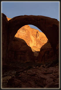 Park
Service paints of regular visits to Rainbow Bridge by masses of Native
Americans for the last several centuries in a sort of Mecca pilgrimage
just doesnt seem to hold water. The historical record shows it is
more likely that some natives visited it occasionally, but the majority
never did. Personally, I dont see how walking under or approaching
Rainbow Bridge is disrespectful. I didnt walk 13 miles through canyons
to disrespect a piece of rock. I walked 13 miles to see a natural creation
of beauty, and I dont think that any position of my body means much at
all to the rock. In 1995, a group of Native Americans calling themselves
Protectors of the Rainbow barricaded the trail to the bridge, and protested
with signs the deplorable standard of living on the Navajo Reservation.
Some were photographed climbing on top of Rainbow Bridge. Is that religious
reverence, to use Rainbow Bridge to promote a quasi-political agenda? Nevertheless,
Dave and I walked up a hill and around the east end of the bridge, and
down the other side, probably contributing much more to erosion than if
we had simply walked underneath. It all seems so politicized and, frankly,
ridiculous. Park
Service paints of regular visits to Rainbow Bridge by masses of Native
Americans for the last several centuries in a sort of Mecca pilgrimage
just doesnt seem to hold water. The historical record shows it is
more likely that some natives visited it occasionally, but the majority
never did. Personally, I dont see how walking under or approaching
Rainbow Bridge is disrespectful. I didnt walk 13 miles through canyons
to disrespect a piece of rock. I walked 13 miles to see a natural creation
of beauty, and I dont think that any position of my body means much at
all to the rock. In 1995, a group of Native Americans calling themselves
Protectors of the Rainbow barricaded the trail to the bridge, and protested
with signs the deplorable standard of living on the Navajo Reservation.
Some were photographed climbing on top of Rainbow Bridge. Is that religious
reverence, to use Rainbow Bridge to promote a quasi-political agenda? Nevertheless,
Dave and I walked up a hill and around the east end of the bridge, and
down the other side, probably contributing much more to erosion than if
we had simply walked underneath. It all seems so politicized and, frankly,
ridiculous.
When we reached flat ground,
we were confronted with a herd of people gathered behind a stone barricade
that we were now on the wrong side of. Rainbow Bridge also serves as a
gateway, holding back the Park Service signs, pavements and shelters that
litter the west side of the bridge. Dozens of brown and white signs proclaimed
Area Closed and We ask for your voluntary cooperation in not approaching
or walking under Rainbow Bridge. We got a few stares as we stepped onto
the paved Park Service viewing area, but heck, how else do you get to the
other side if not by crossing this line? We asked a guy if they were with
the tour boat, but they werent, so we decided to walk down to the dock
to meet the tour boat that was supposed to arrive at 3:00 and see if we
could alter our reservation for the following day. Along the wide,
flat, 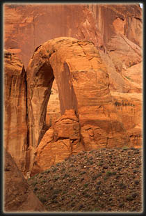 boulder-lined
trail leading down canyon, I stopped to take several photographs of Rainbow
Bridge with snow-dusted Navajo Mt in the background. Every 50 feet a Park
Service sign proclaimed Area Closed. I was frustrated at the ugly signs
and their unavoidable presence. In one photograph, I had Dave stand in
front of a sign to hide it. The trail was very deliberate, with obvious
signs of heavy earth-moving equipment use and backfill. Tire tracks criss-crossed
the trail. Slopes of rock seemed out of place. The lake was very low, the
lowest it had ever been since it reached full level at 3700 feet in June
of 1980, and the thirty or forty feet of white scum on the rock above the
waterline, the bathtub ring, showed the high point. Dozens of steel hooks
and rusted cables hung limply from the walls, dock anchor points from previous
high-water years. Steel culverts and PVC drains channeled water under the
trail to prevent erosion. The entire effect was one of a construction site
in its early stages, and after the pristine beauty and small trail in Cliff
and Bridge Canyons, the scene left a bad taste in my mouth. boulder-lined
trail leading down canyon, I stopped to take several photographs of Rainbow
Bridge with snow-dusted Navajo Mt in the background. Every 50 feet a Park
Service sign proclaimed Area Closed. I was frustrated at the ugly signs
and their unavoidable presence. In one photograph, I had Dave stand in
front of a sign to hide it. The trail was very deliberate, with obvious
signs of heavy earth-moving equipment use and backfill. Tire tracks criss-crossed
the trail. Slopes of rock seemed out of place. The lake was very low, the
lowest it had ever been since it reached full level at 3700 feet in June
of 1980, and the thirty or forty feet of white scum on the rock above the
waterline, the bathtub ring, showed the high point. Dozens of steel hooks
and rusted cables hung limply from the walls, dock anchor points from previous
high-water years. Steel culverts and PVC drains channeled water under the
trail to prevent erosion. The entire effect was one of a construction site
in its early stages, and after the pristine beauty and small trail in Cliff
and Bridge Canyons, the scene left a bad taste in my mouth.
Because of the low water
level, the floating boat dock was at the very limit of the Monument on
the NW side, about 1.2 miles from the bridge, according to the Park Service
employee we consulted there. In high water years the dock is moved
up canyon to give tourists a better chance to stroll up the trail and see
it. Over 150 yards in length, the dock stretched as a floating 10 foot
sidewalk far out into the waters of Lake Powell, confined in the narrow
walls of Bridge Canyon. It has rails, trashcans and a floating 6 flush-toilet
comfort station coated in tasteful faux-adobe. Numerous boats were docked,
but none looked to be a tour boat. We discussed the possible arrival of
a tour boat with the Park Service man, and he confirmed what we had heard,
that they only make the trip if they have enough paying customers, and
might not show up today at all. We sat and waited on the dock, and entertained
ourselves by throwing Ritz cracker bits to the giant 2 foot carp and striped
bass swarming beneath the dock. The Park Service placards state that you
should not feed the wildlife. On the far side of the dock, on the canyon
wall just below high water line, lay a huge pile of bleached tree skeletons,
stranded on a ledge above 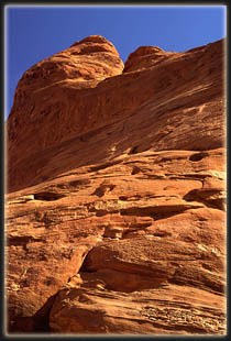 the
water. Their cracked and slimed limbs provided a dismal reminder of the
unwholesome depths of water in the canyon. Soon, all boats departed, and
we were alone on the quiet dock. I walked out to the end to look down the
canyon, but as in all the others, the twisting, sinuous curves of the rock
blocked out all vision after a couple hundred yards. At 5 after 3, we gave
up on the boat, and by 15 after, we left the dock behind. Apparently the
boat arrived just minutes later, because as we took group pictures in front
of Rainbow Bridge, a herd of folks came around the bend after us. Thus,
we were able to gain an audience with Doug, the tour boat driver, and he
told us there would be no problem in catching the early boat the next day.
With that reassurance, we peeled ourselves away from an old man telling
us a highly detailed story about kayakers in Alaska, and blatantly disobeyed
the Area Closed signs as we walked back over the hill, around the bridge,
and resumed the trail back to camp. We arrived back to a cool and shady
camp, and frogs croaking like mechanical sheep by the thousands. The evening
consisted of cooking dinner, filtering water, lancing refilled blisters
and setting up the tent after determining the mosquito/gnat population
just barely warranted such nighttime protection. Originally I had visions
of sunset and starlight photographs of Rainbow Bridge, but when we returned
to camp, there was no way my tired body was going anywhere else that night. the
water. Their cracked and slimed limbs provided a dismal reminder of the
unwholesome depths of water in the canyon. Soon, all boats departed, and
we were alone on the quiet dock. I walked out to the end to look down the
canyon, but as in all the others, the twisting, sinuous curves of the rock
blocked out all vision after a couple hundred yards. At 5 after 3, we gave
up on the boat, and by 15 after, we left the dock behind. Apparently the
boat arrived just minutes later, because as we took group pictures in front
of Rainbow Bridge, a herd of folks came around the bend after us. Thus,
we were able to gain an audience with Doug, the tour boat driver, and he
told us there would be no problem in catching the early boat the next day.
With that reassurance, we peeled ourselves away from an old man telling
us a highly detailed story about kayakers in Alaska, and blatantly disobeyed
the Area Closed signs as we walked back over the hill, around the bridge,
and resumed the trail back to camp. We arrived back to a cool and shady
camp, and frogs croaking like mechanical sheep by the thousands. The evening
consisted of cooking dinner, filtering water, lancing refilled blisters
and setting up the tent after determining the mosquito/gnat population
just barely warranted such nighttime protection. Originally I had visions
of sunset and starlight photographs of Rainbow Bridge, but when we returned
to camp, there was no way my tired body was going anywhere else that night.
As darkness settled in the
canyon, and the first bright stars revealed themselves in the infinite
sky visible only through the narrow crack between the canyon walls, an
indescribable calm filled the air. Far from roads, motors and other bipeds,
the desert sounds completely and utterly erased any thoughts of dismal
offices, fluorescent lights, gas stations and traffic lights. Frogs droned
on the creek bed as they have, every summer night, for millions of years.
Tiny bats flittered silently around camp, swooping gracefully across the
pool of water to snatch mosquitoes and gnats. A hummingbird drank in the
warm nectar of a red penstemon near camp, sending a quiet, intense hum
through the canyon. The staccato song of a canyon wren floated on the dry,
desert air. I think I relaxed more completely than at any time in the last
6 months. As John Muir once said,
going out, I found, was really going
in. The long hike of the day caused drowsiness to set in even before darkness
had completely fallen. When only 4 stars were visible, we retreated to
the tent, and I fell asleep as my head hit my rolled up sweatshirt.
Monday April 21
Dawn broke on John Muirs
birthday. Our friend, Matt Perry, also had his birthday on this day. Endeavoring
to reach Rainbow Bridge before the first morning sunlight touched it, as
well as accommodate Daves request that we not skip breakfast, I set my
alarm (GASP!) for 5:30 so that we could also break camp and filter water
before heading out. We both 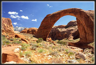 sprung
up as soon as the alarm beeped, and quickly went to work in the cool morning
air cooking breakfast, taking down the tent and shoving sleeping bags into
stuff sacks. I filtered some water, the pump becoming very difficult to
operate after processing some particularly sandy water in Cliff Creek,
and we were off. The night had toughened the tender skin over my
blisters, and my feet felt great as we tromped up the sandy trail. At first
sight of the bridge, just prior to reaching Echo Camp, I stopped and photographed
the bridge, standing in morning shadow with the tips of the west-facing
walls above brilliantly glowing dark orange in the morning sunlight. From
the distance of ½ mile, it looks tiny and delicate. There is nothing
around the bridge to give it realistic scale in a photograph. We continued
on, and stopped now and again to admire the bridge from different viewpoints.
We reached a point on the trail about 200 yards from the bridge, and set
our packs down. It was not yet 7:00, and the bridge was still in shadow.
We clambered down the steep, ledgy slope towards Bridge Creek, careful
of the few delicate plants somehow surviving in a sea of rock, and I set
up my camera on a ledge just 20 feet above the creek bed, and waited for
the sun to reveal the colors of the sandstone that comprised the bridge.
I could have gone lower in the creek bed, but to do so would have allowed
the subsequent curves in the creek channel to block out the view almost
completely. I reflected that I sat well below the high water line of Lake
Powell, and that three years ago, this photograph would not be possible
(and may not be possible for another 30 years). As we waited, I dried out
my boots and we enjoyed the morning stillness of this canyon within a canyon.
A profuse hanging garden had taken hold under an overhang on the opposite
bank, fed by another sourceless seep. Up canyon, an entire slope was covered
with small white oaks, each leaf bright green and deeply lobed. sprung
up as soon as the alarm beeped, and quickly went to work in the cool morning
air cooking breakfast, taking down the tent and shoving sleeping bags into
stuff sacks. I filtered some water, the pump becoming very difficult to
operate after processing some particularly sandy water in Cliff Creek,
and we were off. The night had toughened the tender skin over my
blisters, and my feet felt great as we tromped up the sandy trail. At first
sight of the bridge, just prior to reaching Echo Camp, I stopped and photographed
the bridge, standing in morning shadow with the tips of the west-facing
walls above brilliantly glowing dark orange in the morning sunlight. From
the distance of ½ mile, it looks tiny and delicate. There is nothing
around the bridge to give it realistic scale in a photograph. We continued
on, and stopped now and again to admire the bridge from different viewpoints.
We reached a point on the trail about 200 yards from the bridge, and set
our packs down. It was not yet 7:00, and the bridge was still in shadow.
We clambered down the steep, ledgy slope towards Bridge Creek, careful
of the few delicate plants somehow surviving in a sea of rock, and I set
up my camera on a ledge just 20 feet above the creek bed, and waited for
the sun to reveal the colors of the sandstone that comprised the bridge.
I could have gone lower in the creek bed, but to do so would have allowed
the subsequent curves in the creek channel to block out the view almost
completely. I reflected that I sat well below the high water line of Lake
Powell, and that three years ago, this photograph would not be possible
(and may not be possible for another 30 years). As we waited, I dried out
my boots and we enjoyed the morning stillness of this canyon within a canyon.
A profuse hanging garden had taken hold under an overhang on the opposite
bank, fed by another sourceless seep. Up canyon, an entire slope was covered
with small white oaks, each leaf bright green and deeply lobed.
The sun hit the bridge, and
cast a thin arc shadow on the western canyon wall. I took a few photos,
then we decided to hike up higher and see if we could view it from above
somewhere. There are two sandstone knobs on the east side of the creek
bed, just upstream from the bridge. We walked around both, but found them
too steep to climb. Dave attempted to scale one, but got up about 20 feet
and changed his mind. Instead, we contented with trekking around
the flat flower-covered plain directly beside the arch, so that in places
it appeared as a single columner monolith. During this time, the sun was
obscured by growing high cloud cover in the east, and the colors grew muted
and grey. We made our way down and back to 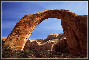 our
packs, and played a few hands of Schnitzel, a game that is only really
fun when gambling money. As we waited, the sun gradually outpaced the clouds,
and soon shadows fell to the ground once again. This was around 10:00.
I took lots of photos in the perfect light, and scrambled down into the
very bottom of Bridge Creek further downstream to take almost vertical
shots of the bridge from the spot of a small waterfall on the south side
of the streambed. Its a good thing I have a very wide angle lens. our
packs, and played a few hands of Schnitzel, a game that is only really
fun when gambling money. As we waited, the sun gradually outpaced the clouds,
and soon shadows fell to the ground once again. This was around 10:00.
I took lots of photos in the perfect light, and scrambled down into the
very bottom of Bridge Creek further downstream to take almost vertical
shots of the bridge from the spot of a small waterfall on the south side
of the streambed. Its a good thing I have a very wide angle lens.
Near 11:00, we shouldered
our gear and walked around to the opposite side of the bridge, to where
we found a completely deserted park service viewing area. A stiff breeze
picked up while we waited beneath a log shelter, and the sun dipped in
and out of clouds. We debated where the photographer was when he took the
aerial view of Rainbow Bridge that graces the cover of the book I bought
on the subject, as well as many NPS signs. There are two high vantage points
from the SW, both seem very difficult, if not impossible, to achieve from
the creek bed. I certainly wasnt going to attempt it. I read that
there are moqui steps to the top of the lower point, a sandstone knob rising
about 200 feet from the top of the creek channel, but I couldnt see them.
By 11:00, the sky was almost
completely clouded over, and the wind grew chilly. We expected to see the
boat passengers rounding the corner any minute, but none came. We were
a bit nervous that no boat would show this morning, owing to too few passengers.
We decided to walk toward the dock, in hopes of seeing any passing boat.
As we walked towards the dock at 11:15 or so, we saw the fist wave of passengers
rounding the bend. Counting 7 in the first group, we felt confident that
this was the tour boat group. As we passed them, we must have created a
little confusion, since there were no other boats at the dock and we were
clearly far from any roads or resorts. Some people stopped to talk briefly
with us, others just said hi. We reached the dock, and Doug was on the
boat by himself. He invited us on board, and we stowed our packs in the
cargo area up front, and spent 15 minutes chatting with Doug about boating,
Lake Powell, points of interest in the area and other such things that
one might guess to discuss with a tour boat operator. He showed Dave points
on the map where the boat now had to make detours due to the low water
level, and explained how the longer route took significantly more time
to complete. After visiting the floating restroom attached to the dock
(complete with flush toilets) and staking out seats on the 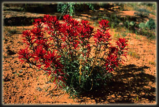 top
of the deck in the open air, the boat pulled out and began cruising back
to Wahweap Marina under a grey, featureless sky. Lots of people sat up
top with us, and Dave and I were both glad to be in the open air to vent
our powerful BO. Natural musk. I was so greasy I could shape my hair like
clay. The boat wove through Bridge Canyon and met up with Forbidden Canyon.
The canyon walls were completely barren of all green plants, and only a
couple of birds were sighted the entire time, some unknown type looking
like black sand pipers. The operator narrated the scenery as we cruised
along and pointed out features that looked like fish, hearts or other animals
in the walls. Numerous side canyons rose up and back, and many twisted
out of view, providing a delicious mystery, and thoughts of a hidden oasis
in the rocks. Forbidding Canyon fed into the main channel of Glen Canyon,
and the lake grew to its full dimension, now to be seen in larger chunks
at a time. The sky was grey, and as the boat sped up, the wind made it
downright cold up top. I put on my windbreaker and took off my hat so it
wouldnt blow off. Most others simply went downstairs to enjoy the comfort
behind the tinted glass windows. top
of the deck in the open air, the boat pulled out and began cruising back
to Wahweap Marina under a grey, featureless sky. Lots of people sat up
top with us, and Dave and I were both glad to be in the open air to vent
our powerful BO. Natural musk. I was so greasy I could shape my hair like
clay. The boat wove through Bridge Canyon and met up with Forbidden Canyon.
The canyon walls were completely barren of all green plants, and only a
couple of birds were sighted the entire time, some unknown type looking
like black sand pipers. The operator narrated the scenery as we cruised
along and pointed out features that looked like fish, hearts or other animals
in the walls. Numerous side canyons rose up and back, and many twisted
out of view, providing a delicious mystery, and thoughts of a hidden oasis
in the rocks. Forbidding Canyon fed into the main channel of Glen Canyon,
and the lake grew to its full dimension, now to be seen in larger chunks
at a time. The sky was grey, and as the boat sped up, the wind made it
downright cold up top. I put on my windbreaker and took off my hat so it
wouldnt blow off. Most others simply went downstairs to enjoy the comfort
behind the tinted glass windows.
We cruised along the black
water under the grey sky, and I reflected on the barren, uninviting look
of the rock-lined lake relative to the lush green canyon bottoms we had
hiked in through. I felt a little sorry for those who only saw Rainbow
Bridge by boat, since everything downstream of the bridge is really nothing
compared to the natural beauty of the upstream canyons. Shortly past Forbidding
Canyon we passed Cathedral Canyon, one of the few side canyons heavily
photographed before the dam. The image of that pristine canyon is so much
more inviting than the lake we now floated on. The reservoir looks very
unnatural, as if only flood water drowning out a town, with only the rooftops
visible. I tried to imagine the look of the canyon as it used to be by
stretching the above-water rock lines and angles downward to a narrow,
twisting canyon, but could not. The miles of water inhibited any vision
of a deep, desert canyon. The best I could do was envision Lodore Canyon
far to the north, another coveted monument canyon that was successfully
defended by conservationists from the Bureau of Wrecklamations dam plans.
This trip was about more than seeing a chunk of rock. It was about visiting
a place of 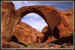 unparalleled
natural beauty that has been the focus of bitter political debate, court
battles and countless books. Glen Canyon dam and the controversies it has
ignited will be around for generations, and will always be a hot topic
in the American Southwest. unparalleled
natural beauty that has been the focus of bitter political debate, court
battles and countless books. Glen Canyon dam and the controversies it has
ignited will be around for generations, and will always be a hot topic
in the American Southwest.
It is the intention of the
Congress that no dam or reservoir constructed under the authorization of
this chapter shall be within any national park or monument. -Section 3
of the Colorado River Storage Project Act of 1956. It fell to the Secretary
of the Interior to make sure waters of Lake Powell did not enter Rainbow
Bridge National Monument. Hassell (1999) gives an excellent account of
the politics involved in the dam construction and Rainbow Bridge preservation
in his book entitled simply, Rainbow Bridge. The gist of the matter is
that a dam was proposed to keep water OUT of Forbidden Canyon (downstream
from Bridge Canyon), and a second pair with a diversion tunnel proposed
at the mouth and head of Bridge Canyon to keep water out from both sides
(to avoid silting behind the lower dam from Bridge Creek). Both dam projects
would have rivaled Glen Canyon Dam itself in size and destructive effect.
Both ideas were scrapped due to logistical difficulties. Later, several
separate lawsuits were brought against the Bureau of Reclamation in an
attempt to enforce Section 3 of the CRSPA. These failed, but were appealed
all the way up to the Supreme Court, which declined to hear the case. At
issue was the right of the Bureau of Reclamation to permanently alter a
National Park through its actions. In the end, economics won, and the electricity
and money generated by having Lake Powell at full pool was favored over
an intact, pristine Rainbow Bridge National Monument. The law has not changed,
and even still that law is being violated daily by the presence of Lake
Powell water inside Rainbow Bridge National Monument. Some geologists have
argued that water to the depth of 50 feet under Rainbow Bridge will inundate
the underlying Kayenta sandstone and cause slippage of the Rainbow Bridge
foundation, resulting in collapse. Untold thousands of dollars were spent
in the 70s and 80s in monitoring the bridge, and the Bureau of Reclamation
determined there was no danger, so all monitoring has ceased. Fears have
not been completely alleviated, however, and some geologists still warn
that a slip of only a millimeter in the bridge foundation will bring it
down. During this entire time, stretching back almost 50 years, the Park
Service has never taken a stand in 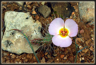 protection
of Rainbow Bridge, and has instead quietly accepted the proclamations of
the Interior Secretary. The precedent of economics over preservation was
set, and continues unabated to this day; glaringly so under the Bush administration. protection
of Rainbow Bridge, and has instead quietly accepted the proclamations of
the Interior Secretary. The precedent of economics over preservation was
set, and continues unabated to this day; glaringly so under the Bush administration.
The boat ride took 2.5 hours,
during which the scenery became monotonous, not helped by the color-muting
cloud cover and whipping wind that drew white caps on the lake. I dozed
off several times, lulled to sleep by the drone of the boats motor. We
drew into Wahweap Marina around 3, trolling slowly by a houseboat parking
lot containing what seemed to be about 8,000 pontoon RVs. Half a mile north
there lay stretched out hundreds of houseboats parked helter skelter on
the water, some no more than 15 feet apart. I guess it must be great fun
to go down to the lake, hop in your houseboat, burn 5 gallons per mile
to drive the houseboat ½ mile away and park it for a week next to
hundreds of others. Actually, it sounds like Hell. The boat pulled into
a courtesy dock and we waited for everyone to leave the boat before going
down and getting our packs. A group of solicitors accosted the folks
in front of us with sales pitches of key rings and refrigerator magnets
bearing images of Rainbow Bridge. For some reason nobody looked twice at
us. I guess our smell kept them at bay. Have to remember that tactic.
Up a hill and to the parking
lot we hiked, our boots tramping over bright green bluegrass where just
hours ago they had tramped over sand and rocks. We found, pleasantly, that
my car was just where Id left it, and we loaded up in a flash and were
off. We halted at the Burger King for a greasy, quick lunch, then motored
on east toward Mexican Hat. I had hoped to see Monument Valley as we drove
north on 163, but apparently all those scenes you see from movies arent
on that road. We reached Mexican Hat around 6, and drove a short while
further before exiting the highway onto a dirt road, then taking a side
road off that and pulling the car over next to a dry creek bed with three
squat cottonwoods. The terrain was good, barren desert, with sick-looking
Ephedra bushes and scattered dwarf primrose in bloom. The cottonwoods
had small, new leaves on them. Under a dark, cloudy sky, we set up the
tent, and went to sleep, although with difficulty due to the heat and the
greasy, havent-showered-in-4-days feel.
Tuesday, April 22
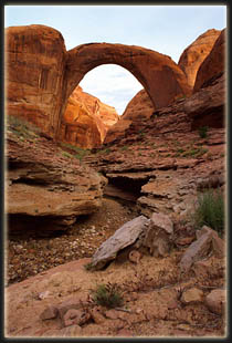 The
next morning Dave got up first around 6:30. I heard him get out of the
tent and tried to ignore it and keep sleeping, but slowly revived anyway.
We packed up camp quickly and hit the road by 7. The
next morning Dave got up first around 6:30. I heard him get out of the
tent and tried to ignore it and keep sleeping, but slowly revived anyway.
We packed up camp quickly and hit the road by 7.
The rest of the trip was
simply driving, ironic since it was Earth Day. We stopped and got breakfast
food in Bluff at a Sinclair gas station. I highly recommend their breakfast
burritos. We drove under cloudy skies most of the day, passing through
Cortez, Durango, Pagosa Springs and Walsenburg. The mountains near Sand
Dunes National Monument were snow-capped, cloud-crowned and beautiful against
the first blue skies we had seen most of the day. We arrived in Colorado
Springs at around 4, and I stayed only long enough to say goodbye to Dave
and his mom.
Driving north, a serious
thunderstorm slowed things down, then I got stuck for over an hour on a
6 mile stretch of I-25 near 225, south of Denver, where incredibly serious
construction is underway (named after a dinosaur for crying out loud).
On top of that, a multi-car accident had slowed traffic to a crawl down
one lane. Once past that, traffic flowed smoothly all the way to Fort Collins.
The first order of business upon reaching home was showering. The first
few shampoo lathers didnt take, so I had to repeat several times. Always
satisfying to make shower water brown isnt it? I called Andra and we got
together and discussed our respective trips. She had me convinced for over
30 minutes that the huge new tattoo around her ankle was real, letting
me freak out a bit before admitting it would rub off in 10 days.
Now Ive reached the end
of the narrative for this trip, having had almost as much fun writing is
as doing it, like reliving the whole trip in all its details. As I finish
this off, it is cloudy, drizzling and about 40 outside. The vermillion
sandstone cliffs above Rainbow Bridge are hard to picture clearly. These
trips never last long enough.
References
Hassell, Hank. 1999. Rainbow
Bridge. Utah State University Press, Logan UT.
NPS (National Park Service)
2002. Glen Canyon, Official Map and Guide. |
;)
;)
;)
;)
;)
;)
;)
;)
;)
;)
;)
;)
;)
;)
;)
;)
;)
;)
;)
;)
;)
;)
;)
;)
;)
;)
;)
;)
;)
;)
;)
;)
;)
;)
;)
