Olomana


Location: windward side of Oahu, near Kailua
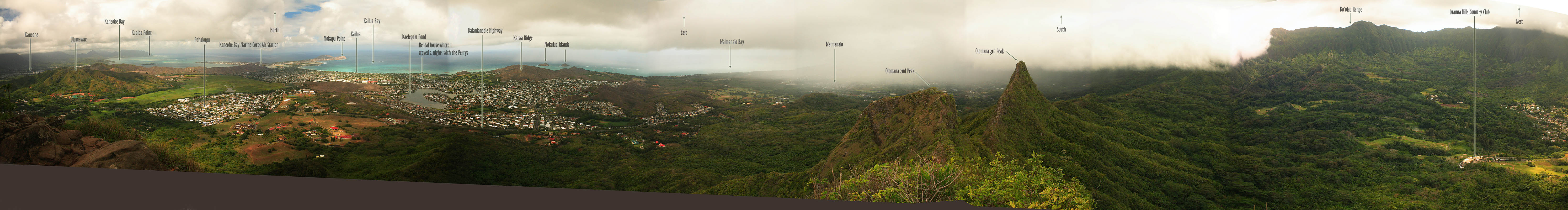
Maps: 1:24K USGS quad: Koko Head
Access: The TH lies about  ½ mile past the security shack for the Luana Hills Country Club. You can park just off the Kalaniana’ole Highway and walk in.
Trail: Very difficult (especially when wet), 5-mile round trip to the first of three peaks
Fees: None


I searched online for an Oahu hiking guide when I first planned to visit Dave on Oahu in 2004. I found and purchased a used copy of Stuart Ball’s Hiker’s Guide to Oahu. On the cover of the revised edition, there is a photo of two hikers standing on top of a plunging cliff face, with a knife-edged peak nearby. The image is of the second and third peaks of Olomana, a spectacular group of three sharp peaks jutting up from the flat plain east of the Ko’olau Range. I was pretty taken with this photo, and it got my blood up to go hiking on Oahu. That first trip in 2004, I never made it to Olomana, nor did I really want to, given the author’s warnings of peril. During my second trip to visit Dave in 2007, shortly before his wedding, we discussed Olomana, and although he had never hiked it, he warned me that he had heard from friends that it was difficult and more than just a little dangerous. I once again shelved the idea, and went about my week hiking very tame trails in the jungles of the Ko’Olau Range. At the rehearsal for Dave’s wedding, I noted that the location of the ceremony was at the foot of Olomana in the Luanna Hills Country Club. At Dave’s wedding, a friend of his named Sean sat next to me at dinner and  while we talked of hiking locations on the island, he suggested I attempt Olomana. I pointed out that all sources rated it as highly dangerous. He concurred it was dangerous, but that if one were careful, it was a perfectly reasonable hike. He furthermore described to me his multiple summits of Olomana, and his descriptions did not sound too terrible. So, two days after the wedding, on my final day in Hawaii, after a short morning hike along Makua Ridge in the northeastern part of Oahu, I decided to give Olomana a shot. If it got too scary, I could always simply turn around. 

The trailhead is on private property, so you have to park outside the front entrance to the Luanna Hills Country Club and walk in past the guardshack. Since I had been to the Country Club twice already, I knew how to get there, although I didn’t know exactly where I should park until I saw the line of 4 cars along the side of the road near Maunawilli Creek. It was shortly after noon when I finally got my stuff together in my pack and headed up the road. Although I had been rained on while hiking that morning, the sky was clear when I started off, and it was consequently pretty hot. I followed the road past the guard shack, said hello to the guard, and kept going another ½ mile to the trailhead which is right along the south side of the road and clearly marked with a sign. I stepped off the road, and with 4 steps left the world of manicured roadside grass and pavement and entered full on jungle. Strawberry guava trees and glossy green laua’e ferns lined the trail, which ran at a moderate incline to an old shack that was almost overtaken by a nearby massive banyan tree. The trail turned left at the shack, and the grade got steeper. As my flight was leaving that evening, I felt compelled to hurry up a little so as to give myself a decent shot at completing the hike in the afternoon, and having enough time left over to shower at a beach park, have dinner and get to the airport on time. Thus, I moved along at a pretty good clip, and I was soon dripping sweat from my nose. I periodically swiped my face with a red handkerchief that I held in my left hand. Although I was breathing heavy, I had lots of energy that day, and I kept going without pause as the trail passed through a dense stand of ironwood, then up a ridgeline that afforded periodic views of the surrounding land. It was apparent that the trail would lead to great views in a very short time. Large wooden posts sat next to the trail at intervals of a few hundred yards, the function of which I never learned. A group of three people passed me on their way down, and we exchanged friendly greetings in passing. Meanwhile the trail continued relentlessly uphill, never going downhill. In a way  this is great, since the purpose of the trail is to get you to the top and any downhill stretches on a summit trail are counterproductive as far as the destination goes. The grade got steeper and steeper, and soon I was using my hands to grip short tree trunks to pull myself along the rocky grade. Through the thin screen of vegetation, I could see the ocean to my left, and the mossy green face of the Ko’Olau Range my right. At a couple of points, fixed ropes aided the ascent, and I was grateful they were there. At the top of the second set of fixed ropes, I stopped for the first time and rested. I couldn’t see the top of Olomana through the vegetation, but I sensed I was getting fairly close. Continuing on, I slowed my pace out of necessity as the trail became much more difficult, mainly due to the steepness of it. If not for the sturdy trees on either side of the trail to hold onto, I would probably have turned back before I reached the 12-foot near-vertical rock face near the summit. A thick rope hung from the top, and there is really nothing to do but pull yourself up when you get here. The trees run out, so it is a fairly unnerving maneuver. I managed to get to the top in a few pulls, but when I got to the top, I found that there is really nothing to grab onto to pull yourself up except smooth rock. I clawed for a good fingerhold and tried to pull myself up, only to be held back by my pack, which had caught on the rock on my right side. Unable to go back down, I simply pulled very hard, and shot forward onto the smooth rock. At the same time, I heard a series of clunks, and I looked over my shoulder to see my water bottle, which had been in the mesh side pocket of my pack, bounce down the rock face and out of sight down the thickly-vegetated slope. I turned my head and looked up the trail to see two guys sitting 10 feet away, watching me. 
"That was my waterbottle," I said, explaining the loud crashings behind me.
"Better it than you," said one of the guys. 
I chuckled, and walked on past them up the hill. The summit was in sight only a hundred yards ahead, and I was anxious to reach it. Despite my enthusiasm, I was forced to go slower than ever, since the trail had narrowed considerably to no more than a couple of feet, with extremely steep drops on either side. Most significant, however, was the sudden lack of sturdy trees lining the trail. There was very little to hold on to, and I found myself instinctively walking in a crouch to lower my center of gravity. There were more areas of rock scrambling, and while pulling myself up a tricky spot, my camera swumg forward from my shoulder and lightly struck the rock face. The lens cap bounced off, and dropped away. To give an idea of how steep the dropoff was at this point, it was a good 20 feet before the lens cap hit anything, afterwhich it bounced out of sight down the mountainside to become a part of the future archeological record of Homo sapiens habitation of Hawaii. 

Near the very top, I reached two more people on their way down.
"Nasty rain coming in from Waimanalo," said the guy.
"Yeah, be careful," said the woman behind him.
"Thanks," I said, and stood off to the side as much as possible for them to pass. 
I took three more large steps and found myself at the very top, finally able to look south. The top of Olomana is not large, 10 feet across at the greatest extent before it plunges back down on the way to the other two peaks. It is mostly bald, so the views are unimpeded in all directions. The second and third peaks are visible to the southwest, both shorter than the first. The trail continues in some form to both of them, although I understand both are considerably more difficult to reach than the one I was standing on. The ocean spreads out to the east, and the mountains rise up  briskly to the west. I instantly saw the rain the other hikers mentioned. A blank white wall of water hung in the air not far south, obscuring the landscape in that direction, and the wind was blowing it towards me. I would have loved to sit down and study the panoramic scene open before me from the summit, but the thought of trying to climb down the rockfaces in a driving rain spurred me to action. I fired off about 20 photographs without taking my eye away from the viewfinder, then turned around and immediately began scrambling back down the walk, crabwalking to maintain my balance on the narrow rock dike of a trail I had come up. After 2 hours of steady hiking, I allowed myself less than 2 minutes to enjoy the summit. On my way down, facing north, I took in the scenes I had not noticed on my way up with my back to them. The delineation between urban areas and the forests is very stark from this high up, as you see the dense housing developments,  like patchwork quilts draped over the hills, snuggle up to a lone, straight line that separates them from the woods. Down to the west I saw the clubhouse the Luanna Hills Country Club, and noted the grassy circle adjacent to the building where Dave and Malia were married two days before. I kept moving down as fast as I dared. I had no desire to beat the rain to my car, but I had a strong desire to beat the rain to the last of the fixed ropes, where I knew the stones underfoot would be almost impossibly slick if they got wet. I was very tense, and I have to rate this section of the climb as the scariest hiking I’ve ever done. I wasn’t terribly concerned about falling, but my muscles were tensed and jittery all the same. At the downclimb that claimed my waterbottle, I hesitated long enough to decide on the least-risky way to get down the rockface. In just a few seconds, that was done, and I felt much relieved. I knew that the rest of the way was lined with trees that would help keep me upright and on top of the ridge. I walked back along the rock face a ways to the last known location of my waterbottle, and craned my neck out to try to catch a glimpse of it. Down the steep slope about 6 feet, I saw it, barely held in place by a thin shrub stem. I grabbed onto a sturdy looking tree, and leaned out over the incline, stretching slowly toward the bottle with my right hand. Got it. I pulled myself back up and drained the entire bottle at once before stowing it in my pack and heading down. Before I could make it to the other sets of fixed ropes, the rain came, though not as much of it came as I had expected. It never rained hard, but big, fat drops splashed the trail with enough quantity as to make it snotty in the mud and slick as ice on the mossy rocks. Every step was taken with both hands firmly wrapped around the sturdiest tree or shrub in sight. I headed down as quickly as I dared lest the rain pick up, and at one point saw the two hikers last on the summit not more than 50 yards ahead of me. The descents down the fixed rope areas would have been flat out impossible without the ropes given the slickness of the rocks. My vibram soled boots slid across the rocks literally like they were solid ice. I’ve never felt my boots grip rock less than here. By clumsily lowering myself from tree to tree via the ropes, I finally made it down both sets of ropelines, and onto more level ground where the adrenaline of the descent finally began to wane. The remainder of the hike went very quickly through the intermittent rain showers. I reached the pavement and began heading towards the car, when the rain finally came with a fury that sent me running into the trees for shelter. That helped quite a bit, so that when it finally abated after 5 minutes, I was merely wet on my shoulders and head as opposed to thoroughly soaked on all sides. Ten minutes later, I was back at the car, and back on the road.

****
Ko'olau Trail above Maunawilli

Beautiful old banyan tree
Thick jungle near the beginning of the trail
Fields near the TH
Fields near the trailhead, looking west towards Ko'olau Range

Olomana from Kaluanui Ridge
Ko'olau Range through the trees
Steep section of Olomana Trail
More steepness on the Olomana Trail
Laua’e ferns line most of the trail
More steep, fern-lined trail
Short stretch of trail through Ironwoods
Laua’e fern
Looking north from Olomana
Second and third peaks of Olomana
Trail near the summit of Olomana
Scary stretch of narrow ridge trail near the summit
Slightly insane scramble to the summit
Heart-pounding rock climb with fixed rope near the summit
270' panorama covering parts of 5 USGS quads of the windward coast from the summit of Olomana:
270' panorama from Olomana summit

Back                                    Next


Page created 1-26-08
Comments