August 14-16, 2004 Even with a map, the route is sometimes hard to find. Especially when the map doesnt show the numerous little dirt roads and forks that one encounters on the ground en route to the trailhead. Yet even that is part of the fun .part of exploration. If every route were perfectly marked, with no chance of getting lost, some of the adventure would be lost. As I pulled out of the little gas station in Walden, munching a nitrite-laden hot dog, I had a firm idea of where I was going, but not such a firm idea of how to get there. Under a perfect blue sky, I cruised my dusty green passenger vehicle past the three buildings that make up the town of Rand, and made the appropriate turn left off the pavement shortly thereafter. After that, I was a little lost for awhile. Dirt roads led in multiple directions, and many were not on my map. I drove a little up the road I believed to be the right one when a group of folks on ATVs came motoring down and told me that I wouldnt be able to make it any further up the road. I asked them if it led to Jacks Park. Emphatically, they replied, No.. Trust the locals? I wont again. This time I did, backtracked several miles and replayed the drive again, paying very special attention to turns and topography. Ending up back at the same road, I determined it must be the right one. Before the wide graded surface gives way to steep rocky surface, there is a makeshift campground next to a stream. I decided to park here, even though it was miles from my intended trailhead, since the folks on ATVs had said my car wouldnt make it up. Frank, my quiet canine hiking partner was with me, and itching to get out of the car and nose around. I could empathize with that feeling, after 4 hours in the car. I parked in the shade of spruces and popped the trunk to pack up my gear for transport up the valley. Several 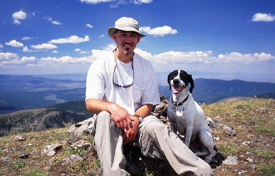 RVs
were parked nearby, and I waved casually to the lounging owners. As I shouldered
my pack, we regarded each other with equal amazement at the others recreation
preference. Frank and I walked about 300 yards up the road when I
determined that my car could indeed make it up at least this far, and easily
up further as far as I could see. So, I cached my pack behind a large pine
bole, and jogged back to the car. Hopping in, I saw a white truck come
around the corner and pass me, slowly churning on up the hill I had just
walked down. I slowly followed him, steering carefully to avoid scraping
the bottom of the car on jagged rocks. Having higher clearance, he soon
crept ahead of me enough so that I could no longer see his bumper. I stopped
and grabbed my pack and tossed it in the trunk. The road was narrow, and
very much unimproved. Its jagged rocks and deep ruts might have seen a
grader sometimes in the 60s, but had seen many spring thaws and thunderstorms
since. I went slow and steered with concentration and managed fine. About
2-3 miles up the road, however, I encountered a stretch that made sweat
bead on my brow. The rocks were so sharp and jagged, and the grade so steep,
I thought surely I would puncture a tire. I tried to stay away from the
edge of the road that dropped off into the creek below to avoid skidding
down incase of a flat. The road was so narrow that turning around was physically
impossible, and the rocks so jagged and tall, reverse wouldnt allow me
to steer around them. Thus, I continued on up until the road leveled out
again. A small turnout on the left side provided the perfect spot to park
it. Thankful for having made it this far without incident, I determined
not to press my luck any further. Frank and I once again got out and began
hiking up the road. The sun was high in the sky, it being around 1PM, and
the warm summer air was perfect. In 200 yards, I met the occupants of the
white truck, which was now parked along the left side of the road. A man
my age and his small son were sitting on a rock outcropping overlooking
the creek far below. He asked me how far I made it up and RVs
were parked nearby, and I waved casually to the lounging owners. As I shouldered
my pack, we regarded each other with equal amazement at the others recreation
preference. Frank and I walked about 300 yards up the road when I
determined that my car could indeed make it up at least this far, and easily
up further as far as I could see. So, I cached my pack behind a large pine
bole, and jogged back to the car. Hopping in, I saw a white truck come
around the corner and pass me, slowly churning on up the hill I had just
walked down. I slowly followed him, steering carefully to avoid scraping
the bottom of the car on jagged rocks. Having higher clearance, he soon
crept ahead of me enough so that I could no longer see his bumper. I stopped
and grabbed my pack and tossed it in the trunk. The road was narrow, and
very much unimproved. Its jagged rocks and deep ruts might have seen a
grader sometimes in the 60s, but had seen many spring thaws and thunderstorms
since. I went slow and steered with concentration and managed fine. About
2-3 miles up the road, however, I encountered a stretch that made sweat
bead on my brow. The rocks were so sharp and jagged, and the grade so steep,
I thought surely I would puncture a tire. I tried to stay away from the
edge of the road that dropped off into the creek below to avoid skidding
down incase of a flat. The road was so narrow that turning around was physically
impossible, and the rocks so jagged and tall, reverse wouldnt allow me
to steer around them. Thus, I continued on up until the road leveled out
again. A small turnout on the left side provided the perfect spot to park
it. Thankful for having made it this far without incident, I determined
not to press my luck any further. Frank and I once again got out and began
hiking up the road. The sun was high in the sky, it being around 1PM, and
the warm summer air was perfect. In 200 yards, I met the occupants of the
white truck, which was now parked along the left side of the road. A man
my age and his small son were sitting on a rock outcropping overlooking
the creek far below. He asked me how far I made it up and 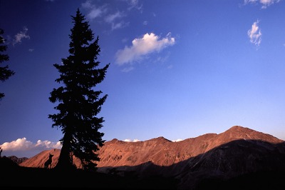 mentioned
that he didnt think my car could make it very far. I told him as long
as I go slow, I can make it almost anywhere. I wished them well, and continued
on. I reached a fork in the road where the left fork continued on to terra
incognita and the right fork up to Jacks Park. The road to Jacks Park
is washed out shortly beyond this fork, but enough of the road remained
for me to walk across the creek. The road meandered uphill at a comfortable
slope for about ½ mile. Finally, after what seemed like an entire
day spent trying to reach it, I stood before the Jacks Park trailhead
billboard. Wasting no time, Frank and I exited the road and began tromping
down the trail toward Jacks Park, a wide spongy meadow with deep gashes
from irresponsible motorcyclists tearing up the fragile sod. From the open
meadow, large green peaks sloped up to the west, and I tried to guess at
the route but couldnt quite discern it. Beyond the meadow, the trail entered
a thick forest of spruce and fir with dry soil and brown undergrowth. My
boots grew dusty from the powdery silt that sprung up with each footfall.
Frank zoomed up and down the trail sniffing out critters. After a mile
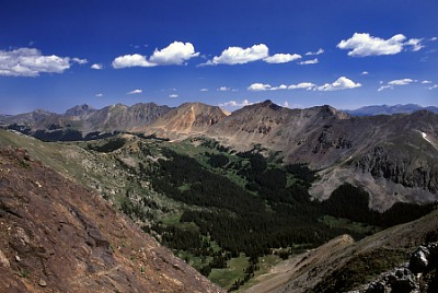
or two, the trail started cresting above treeline, and views of the surrounding
peaks became more dramatic. Emerald green slopes of towering massifs blended
with rusty-red boulder fields and deep blue sky. The trail grew quite steep
in the last mile or so toward Bowen Pass. I stopped frequently to photograph
the wildflowers and emerald peaks reflected in clear tarns of snowmelt.
A single man passed me going in the opposite direction without even a daypack,
and I wondered where in the hell he came from and where in the world he
was going. Naturally, I didnt ask. The final few yards up to Bowen Pass
were very tiresome, and I took them very slowly, resting often. My legs
burned after every 5th step, necessitating a brief stop. Cresting the pass
was a nice reward, however, as Bowen Gulch gaped before me, with Bowen mentioned
that he didnt think my car could make it very far. I told him as long
as I go slow, I can make it almost anywhere. I wished them well, and continued
on. I reached a fork in the road where the left fork continued on to terra
incognita and the right fork up to Jacks Park. The road to Jacks Park
is washed out shortly beyond this fork, but enough of the road remained
for me to walk across the creek. The road meandered uphill at a comfortable
slope for about ½ mile. Finally, after what seemed like an entire
day spent trying to reach it, I stood before the Jacks Park trailhead
billboard. Wasting no time, Frank and I exited the road and began tromping
down the trail toward Jacks Park, a wide spongy meadow with deep gashes
from irresponsible motorcyclists tearing up the fragile sod. From the open
meadow, large green peaks sloped up to the west, and I tried to guess at
the route but couldnt quite discern it. Beyond the meadow, the trail entered
a thick forest of spruce and fir with dry soil and brown undergrowth. My
boots grew dusty from the powdery silt that sprung up with each footfall.
Frank zoomed up and down the trail sniffing out critters. After a mile
or two, the trail started cresting above treeline, and views of the surrounding
peaks became more dramatic. Emerald green slopes of towering massifs blended
with rusty-red boulder fields and deep blue sky. The trail grew quite steep
in the last mile or so toward Bowen Pass. I stopped frequently to photograph
the wildflowers and emerald peaks reflected in clear tarns of snowmelt.
A single man passed me going in the opposite direction without even a daypack,
and I wondered where in the hell he came from and where in the world he
was going. Naturally, I didnt ask. The final few yards up to Bowen Pass
were very tiresome, and I took them very slowly, resting often. My legs
burned after every 5th step, necessitating a brief stop. Cresting the pass
was a nice reward, however, as Bowen Gulch gaped before me, with Bowen  Mt
on the left and Ruby Mt on the right, combining to form a giant U-shaped
valley that sloped very steeply south for a mile, then sharply east and
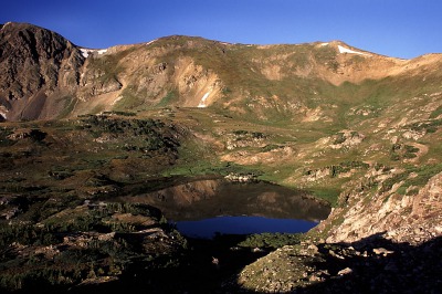
out of sight. I could see Ruby Lake sitting placidly above treeline, and
the scattered pockets of spruce further down where I intended to camp.
Having the advantage of gravity, Frank and I made it down to the spruce
trees in very short order and selected a camp after scouting several areas.
I set up the tent in a hidden pocket of shade deep within a spruce grove
and then crossed a meadow to another spruce grove to hang my food and have
dinner. I sat on a large boulder and cooked a package of Ramen noodles,
which I quickly scarfed down along with a few crackers. No need for manners
when your only camping buddy is a dog. Frank nibbled on his dog feed bag,
but only as a courtesy: his mind was elsewhere. I packed up the food and
hung it in the tree nearby. As I was doing so, I heard a loud band of folks
nearby, heading uphill. That strange primal desire to remain hidden took
over, and I sat down slowly in the deep shade of the trees to watch. I
hoped they would pass over Bowen Pass and move on, but they seemed to be
scouting a camp site on the shores of Ruby Lake, about ¼ mile uphill.
I was a tad disappointed since I had planned on exploring the lake just
after supper, and hated to do so now because of the human visitors. They
would feel invaded if I walked through their camp, and I would feel uncomfortable
doing so
thus, cancellation. I changed plans and scouted due west up a
steep incline to a rocky outcropping that provided a nice view of sunset
on some of Rocky Mountain National Parks taller peaks. I examined the
map to try to figure out which peaks I was looking at, but the jumble of
shadow and dark forest stymied any meaningful interpretation and I gave
up. I took lots of sunset photos, and I now believe I left a roll of film
sitting on the rock where I changed film. Thats the first time I ever
lost a roll of film. It was incredibly disappointing since that roll had
lots of shots of falls in the Mt Zirkel wilderness just across North Park.
Justification for a return trip next year, so no worries. After the sun
had set, I picked my way down back to camp with Frank in tow. We went to
sleep immediately. Mt
on the left and Ruby Mt on the right, combining to form a giant U-shaped
valley that sloped very steeply south for a mile, then sharply east and
out of sight. I could see Ruby Lake sitting placidly above treeline, and
the scattered pockets of spruce further down where I intended to camp.
Having the advantage of gravity, Frank and I made it down to the spruce
trees in very short order and selected a camp after scouting several areas.
I set up the tent in a hidden pocket of shade deep within a spruce grove
and then crossed a meadow to another spruce grove to hang my food and have
dinner. I sat on a large boulder and cooked a package of Ramen noodles,
which I quickly scarfed down along with a few crackers. No need for manners
when your only camping buddy is a dog. Frank nibbled on his dog feed bag,
but only as a courtesy: his mind was elsewhere. I packed up the food and
hung it in the tree nearby. As I was doing so, I heard a loud band of folks
nearby, heading uphill. That strange primal desire to remain hidden took
over, and I sat down slowly in the deep shade of the trees to watch. I
hoped they would pass over Bowen Pass and move on, but they seemed to be
scouting a camp site on the shores of Ruby Lake, about ¼ mile uphill.
I was a tad disappointed since I had planned on exploring the lake just
after supper, and hated to do so now because of the human visitors. They
would feel invaded if I walked through their camp, and I would feel uncomfortable
doing so
thus, cancellation. I changed plans and scouted due west up a
steep incline to a rocky outcropping that provided a nice view of sunset
on some of Rocky Mountain National Parks taller peaks. I examined the
map to try to figure out which peaks I was looking at, but the jumble of
shadow and dark forest stymied any meaningful interpretation and I gave
up. I took lots of sunset photos, and I now believe I left a roll of film
sitting on the rock where I changed film. Thats the first time I ever
lost a roll of film. It was incredibly disappointing since that roll had
lots of shots of falls in the Mt Zirkel wilderness just across North Park.
Justification for a return trip next year, so no worries. After the sun
had set, I picked my way down back to camp with Frank in tow. We went to
sleep immediately.
I ate
a quick snack breakfast in the warming morning sunlight by my food cache
and packed up camp. Before 8 Frank and I were on the trail heading
back over Bowen Pass. I looked for the tent that I expected to see around
Ruby Lake and found it without trouble
the fuschia fabric formed a giant
octagon about 10 feet from the lakeshore. At Bowen Pass I studied the map
and decided to take a bit of a risk and leave the trail, which goes downhill
from the pass and through a cirque before going back up over Parika Pass,
in favor of the unofficial route of following the continental divide over
to the same point. I struck off to the east of Bowen Pass up a shoulder
of Bowen Peak. The going was very steep, and I cut acute switchbacks back
and forth the entire way up, the edges of my boots gripping the carpeted
hillside. Frank confounded me with his limitless energy and seeming ease
with which he ascended 200 feet at a stretch. I stopped often to enjoy
the scenery around me, and the beautiful summer sky. Reaching the top,
I surveyed I enjoyed the delicious feeling of loneliness. This always seems to have a bad connotation in popular press, but it can be very desirable in a world packed with humans. I sat on the crest of the ridge and watched the puffy clouds slide along their east-bound course like slugs in a limitless blue field. The gaping bowl of a cirque fell away both in the east and west, and the plains of North Park stretched all the way to Baker Peak in the Park Range. I had already decided to ask Andra to marry me, and had already talked to her Dad about it. I planned on asking her at Leg Lake in the Popo Agie Wilderness of Wyoming the following weekend. So I was conscious of the finality of decisions, and of the significance of loneliness. I harbored doubts marriage about as much as my doubts about the route I took it might not work out well, but I wouldnt have tried it if I thought it wouldnt. Too much thinking at high altitudes can give one a headache, so I shouldered my pack again and continued on the last march of Sam the Bachelor.
As the sun grew high in the sky, I returned to camp amid beautiful wildflower fields and packed up. We hiked out along the trail that ran by the lake shore, then uphill for a long way to Parika Pass. When I had started up the hill from the lake the sky looked blue and clear, but so long is the trail to top the pass that by the time I arrived, the sky had filled with a thick layer of low, grey clouds. I stopped just over the top for a short snack, and then lumbered on downhill. The first truly threatening clouds of the trip blocked out the blue sky utterly, and I was glad I was heading down. I met one person who was heading up, and didnt envy their position. The trail back seemed longer, but perhaps that was because I was tired and it was cloudy. I intersected the trail I had wanted to intersect, but at a different point much further down the valley than I had wanted. Thus, it is possible that it was a longer route. The trail marking is a bit sketchy in places, so who knows how far off I really was. I was
pleased to find my car intact, and I loaded it and drove out carefully
under a gentle intermittent sprinkle.
|
| Page
created February 9, 2005
Comments |
  |
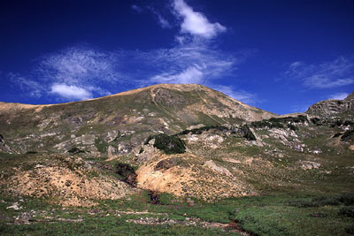
 Location:
Bowen Pass and Parika Lake; Arapahoe National Forest
Location:
Bowen Pass and Parika Lake; Arapahoe National Forest
 Waking
the next morning around dawn, I heard Frank growling softly enough to alert
me, but not so loud that whatever was outside might hear him and come get
him. I threw on my shirt and shoes and stepped cautiously outside the tent.
Frank softly growled in the direction of the sun-drenched meadow of tall,
green grass, and I followed the gaze of his black eyes. I saw a pack of
coyotes sweeping the meadow, heading downhill. The closest one was about
50 yards away. If he noticed me, he gave no hint of it, as he didnt break
stride or look around. They were grey and perfectly silent. Several pups
jumped through the tall grass on the far side of the meadow. I couldnt
tell how many, but at least 3. All of them were coming from the general
area of my food cache, so I was mildly alarmed at having my food stolen,
until I recalled how well I had hung the food high up in the tree. Fun
to see wildlife. I watched them until they disappeared into the thick woods
bordering the south side of the meadow.
Waking
the next morning around dawn, I heard Frank growling softly enough to alert
me, but not so loud that whatever was outside might hear him and come get
him. I threw on my shirt and shoes and stepped cautiously outside the tent.
Frank softly growled in the direction of the sun-drenched meadow of tall,
green grass, and I followed the gaze of his black eyes. I saw a pack of
coyotes sweeping the meadow, heading downhill. The closest one was about
50 yards away. If he noticed me, he gave no hint of it, as he didnt break
stride or look around. They were grey and perfectly silent. Several pups
jumped through the tall grass on the far side of the meadow. I couldnt
tell how many, but at least 3. All of them were coming from the general
area of my food cache, so I was mildly alarmed at having my food stolen,
until I recalled how well I had hung the food high up in the tree. Fun
to see wildlife. I watched them until they disappeared into the thick woods
bordering the south side of the meadow.
 the
route ahead of me and relaxed as I saw it would be relatively easy to complete.
The trickiest part was next, where I had to clamor over sharp rocks and
narrow ledges
not so easy with a 50-lb pack in strong wind. Nevertheless,
in no time I was past it and walking casually and comfortably along the
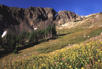
relatively flat crest, over a smooth carpet of tussock grass and alpine
flowers, many of which were in bloom. To the west I could see the mountains
of the Mt Zirkel wilderness area, and from certain spots I could see Trail
Ridge Rd as it ran through Coyote Valley in Rocky Mountain National Park
to the east.
the
route ahead of me and relaxed as I saw it would be relatively easy to complete.
The trickiest part was next, where I had to clamor over sharp rocks and
narrow ledges
not so easy with a 50-lb pack in strong wind. Nevertheless,
in no time I was past it and walking casually and comfortably along the
relatively flat crest, over a smooth carpet of tussock grass and alpine
flowers, many of which were in bloom. To the west I could see the mountains
of the Mt Zirkel wilderness area, and from certain spots I could see Trail
Ridge Rd as it ran through Coyote Valley in Rocky Mountain National Park
to the east.
 We
hiked on the ridge for a fairly long time, covering perhaps a mile, before
we crested again at a high unnamed peak overlooking Parika Lake from the
south. From so high up, Parika Lake appeared small and pitiful, but it
was the only lake around, so I decided to go down to it. Clattering of
hooves and falling rocks nearby alerted me to a startled herd of bighorn
sheep, trotting away from me along the ridge that led down towards the
park. I shot some photographs, then headed northwest along the ridge to
Fairview Mt. Frank and I stopped and had some lunch. I watched two horses
carrying riders down the long shallow trail to Parika Lake. I followed
the ridge from Fairview Mt north, crossing the trail and heading on up
to the summit of Parika Peak, the only named peak I summited the entire
trip. The weather was starting to threaten thunderstorm as large puffy
cumulous clouds converged into darker masses away to the west. Amidst a
growing wind, Frank and I headed downhill. When I reached the trail, I
could see the horses tethered by Parika Lake, their riders fishing in the
water nearby. I followed the trail down towards the lake, but broke off
just before it so as to avoid other humans. I walked across the grassy
tundra to the east and found a great spot in a tiny spruce island about
¼ mile from the lake. My extended hike above treeline in heavy wind
had dehydrated me, and I had a terrible headache by the time the tent was
pitched in the shade of the spruces. I filtered water from a nearby creek,
gulped it down and splashed water on my face and neck to rinse away the
layer of crusted salt. The weather stayed nice and sunny, but I could see
the clouds developing into thunderstorms off to the east. I took a short
nap with Frank in the tent to try to get rid of my headache. As the sun
sank lower on the western horizon, the light filled the tent and woke me
up. Frank and I went over to Parika Lake to find it empty of humans. I
explored the flower-covered inlet stream area, and Frank stalked moles
in the tall grass. As light faded, we returned to the tent. For dinner
I cooked ramen noodles again, and finished them just before sunset. To
the south, just above me, was the rocky peak from where I had first seen
Parika Lake. As darkness enveloped the camp, Frank treed a squirrel in
a spruce tree separated from the rest, so that the squirrel could not jump
to another tree and be gone. The squirrel chattered and chipped, but would
not come down any closer to the ground. Frank sat down and basically camped
out for the long haul, waiting for the squirrel to jump down into his mouth,
I guess. I walked the 30 yards or so downhill to the creek and filtered
water, and still he stayed with it. The camp grew dark, and the sun shone
orange on the divide peaks of Howard, Cirrus, Nimbus and Cumulous, and
still Frank waited it out. I was ready to go to bed when I had to tear
him away from the tree and zip up the tent with him inside.
We
hiked on the ridge for a fairly long time, covering perhaps a mile, before
we crested again at a high unnamed peak overlooking Parika Lake from the
south. From so high up, Parika Lake appeared small and pitiful, but it
was the only lake around, so I decided to go down to it. Clattering of
hooves and falling rocks nearby alerted me to a startled herd of bighorn
sheep, trotting away from me along the ridge that led down towards the
park. I shot some photographs, then headed northwest along the ridge to
Fairview Mt. Frank and I stopped and had some lunch. I watched two horses
carrying riders down the long shallow trail to Parika Lake. I followed
the ridge from Fairview Mt north, crossing the trail and heading on up
to the summit of Parika Peak, the only named peak I summited the entire
trip. The weather was starting to threaten thunderstorm as large puffy
cumulous clouds converged into darker masses away to the west. Amidst a
growing wind, Frank and I headed downhill. When I reached the trail, I
could see the horses tethered by Parika Lake, their riders fishing in the
water nearby. I followed the trail down towards the lake, but broke off
just before it so as to avoid other humans. I walked across the grassy
tundra to the east and found a great spot in a tiny spruce island about
¼ mile from the lake. My extended hike above treeline in heavy wind
had dehydrated me, and I had a terrible headache by the time the tent was
pitched in the shade of the spruces. I filtered water from a nearby creek,
gulped it down and splashed water on my face and neck to rinse away the
layer of crusted salt. The weather stayed nice and sunny, but I could see
the clouds developing into thunderstorms off to the east. I took a short
nap with Frank in the tent to try to get rid of my headache. As the sun
sank lower on the western horizon, the light filled the tent and woke me
up. Frank and I went over to Parika Lake to find it empty of humans. I
explored the flower-covered inlet stream area, and Frank stalked moles
in the tall grass. As light faded, we returned to the tent. For dinner
I cooked ramen noodles again, and finished them just before sunset. To
the south, just above me, was the rocky peak from where I had first seen
Parika Lake. As darkness enveloped the camp, Frank treed a squirrel in
a spruce tree separated from the rest, so that the squirrel could not jump
to another tree and be gone. The squirrel chattered and chipped, but would
not come down any closer to the ground. Frank sat down and basically camped
out for the long haul, waiting for the squirrel to jump down into his mouth,
I guess. I walked the 30 yards or so downhill to the creek and filtered
water, and still he stayed with it. The camp grew dark, and the sun shone
orange on the divide peaks of Howard, Cirrus, Nimbus and Cumulous, and
still Frank waited it out. I was ready to go to bed when I had to tear
him away from the tree and zip up the tent with him inside.
 The
next morning I woke up minutes after sunrise and quickly walked over to
Parika Lake to enjoy the morning light on the still water. A part of me
missed having a Colorado fishing license as the water began to boil with
trout. I simply sat back on the northern shore taking photographs and enjoying
Franks expression as he tried to discern from where the pika was chirping
at him. Parika Lake empties to the east and sends a stream of water down
Baker Gulch, past the ghost town of Gaskill, towards the fledgling
North Fork of the Colorado River. Because of the meandering Continental
Divide, Parika lake sits east of the divide, but drains to the west. You
might have to look at a map to believe it. The channel that has rippled
down Baker Gulch for thousands of years was partly diverted into the Grand
Ditch in 1936, where it flowed northward, following the countour of the
mountains to La Poudre Pass, where it dumped into the Cache La Poudre River
and ran east to Fort Collins, rather than into the Colorado and west to
Grand Junction. Started in 1904, the Grand Ditch ultimately extended 14
miles into the Colorado River watershed to steal snowmelt from the Never
Summer Range in order to supplement the agricultural industry of the plains
to the east. Baker Gulch was the last stop of the Grand Ditch. If I were
so inclined, I could have walked there since it is not far from the shores
of Parika Lake. Interestingly, at the time of the construction, the Colorado
River was called the Grand River, which is why Grand Lake sits on the western
edge of Rocky Mountain National Park, and why there is a town at the junction
of the Dolores River called Grand Junction (junction of the Grand and Dolores
Rivers).
The
next morning I woke up minutes after sunrise and quickly walked over to
Parika Lake to enjoy the morning light on the still water. A part of me
missed having a Colorado fishing license as the water began to boil with
trout. I simply sat back on the northern shore taking photographs and enjoying
Franks expression as he tried to discern from where the pika was chirping
at him. Parika Lake empties to the east and sends a stream of water down
Baker Gulch, past the ghost town of Gaskill, towards the fledgling
North Fork of the Colorado River. Because of the meandering Continental
Divide, Parika lake sits east of the divide, but drains to the west. You
might have to look at a map to believe it. The channel that has rippled
down Baker Gulch for thousands of years was partly diverted into the Grand
Ditch in 1936, where it flowed northward, following the countour of the
mountains to La Poudre Pass, where it dumped into the Cache La Poudre River
and ran east to Fort Collins, rather than into the Colorado and west to
Grand Junction. Started in 1904, the Grand Ditch ultimately extended 14
miles into the Colorado River watershed to steal snowmelt from the Never
Summer Range in order to supplement the agricultural industry of the plains
to the east. Baker Gulch was the last stop of the Grand Ditch. If I were
so inclined, I could have walked there since it is not far from the shores
of Parika Lake. Interestingly, at the time of the construction, the Colorado
River was called the Grand River, which is why Grand Lake sits on the western
edge of Rocky Mountain National Park, and why there is a town at the junction
of the Dolores River called Grand Junction (junction of the Grand and Dolores
Rivers).