| August 22 Monday
Under sunny blue skies I drove west along the winding road leading through
the narrow canyon of the Big Thompson River towards Estes Park, the same
canyon in which dozens of people died in a flash flood in 1976. Placards
instruct, "In case of flood, Climb to safety", but there are long sections
of vertical cliffs where only Spiderman could climb to safety.
It had been a miserable drive in the old Toyota for the last 2 hours.
I seldom drive the car, having the luxury of commuting exclusively on bicycle.
Consequently, it sat in the garage for a couple of weeks, unused, and picked
up a family of mice somewhere in the inner recesses of the engine. Three
days before, I took the car out to the grocery store, not noticing anything.
My working theory is that I smoked the entire family of mice on that trip
by the engine heat, and they proceeded to rot in the car. By the third
day, the were at full-bore decomp stage. If youve never encountered the
insidious odor of rotting mouse, you just dont know what youre missing.
The deafening roar of wind whipping through your hair at 77 mph on the
interstate is a triviality compared with even minor wiffs of juicy runny
mouse flesh, slow-roasting in the exhaust system. I worried that the smell
would soak into my clothes, attracting bears and other critters while I
camped. On the other hand, even a morning of noisy driving in a smelly
car on your way to a national park is better than a great morning at work,
so I couldn't complain, and smiled at my freedom from corporate responsibility.
A full week off to explore the mountains...always welcome.
The road led into beautiful Estes Park, a gem surrounded by mountains,
first settled by Joel Estes in 1860 with one lonely cabin and now littered
from top to bottom with businesses and resorts. In the distance the bright
peaks beckoned, showing ridges and detailed furrows that one never sees
from the plains. The road led past hotels, motels, cabins, outfitters,
grocery marts, auto dealers, gas stations, and every conceivable restaurant.
Behind the main streets lay rows of houses extending up the slopes in the
distance as far as human engineering can allow. The first proponents of
Rocky Mountain National Park described the healthful air and scenic splendor
of the area, the wildlife, the wildflowers, the conifers
..all gone from
Estes Park. But for the action of the US Congress in 1915, Estes Park might
have been included in the National Park, originally planned to be 1000
square miles, ending up being only 350. Many people enjoy the quaint
streets of Estes Park, no doubt, but there are plenty of places to build
quaint streets across America, but very few places left to enjoy wilderness.
Was wall to wall development of Estes Park in the best interests of this
country? Personally I think no, but others are welcome to disagree.
Just east of the park entrance lies the Beaver Meadows Visitor Center.
I stopped in and walked down a sidewalk about 200 yards through Ponderosa
pines to the backcountry office to register my permit, as required. Reservations
for popular parks like Rocky Mountain or Glacier are not only recommended,
but typically essential. I had no reservation. I stepped up to the nice
woman at the empty and quiet counter and told her so.
"I have 4 days to backpack. Id like to go somewhere around here",
I say, and vaguely flap a hand over the Fern Lake and Glacier Gorge area
on the laminated map taped to the counter. "Whats available?"
She surprised me with her apparent earnestness as setting up a great
itinerary. Of course, the areas I had wanted were the areas everyone wanted
and were all full. She recommended several options, then countermanded
them before I had time to comment. She knew the park well and seemed to
sense that I wasnt looking for a short loop, but a nice, long, rugged
hike. Finally she suggested a particular route leading to the western slope
and back that looked good and was sold well, so I signed up for it, reserving
campsites at 2 different locations in two different watersheds. The fee
for the permit was $20, which is a steal. I handed her a crisp $20 bill
and she recoiled as if it was kryptonite.
"Were not allowed to handle money", she said, and pointed down the
counter. "You can put it in an envelope and drop it in there."
I walked to the end of the counter, pulled out an envelope, put my
$20 in it and dropped it into the sealed metal box. They just dont trust
their rangers around here. Even 7-11 allows its clerks to handle money
(no offense to 7-11 employees, Im sure theyre a trustworthy crowd).
Back in the car, I drove through the entrance station, forking out an
additional $15 for the right to drive my car as far as Bear Lake. I saw
a sign as I pulled through: "Bear Lake parking lot full. Use shuttle."
I drove west through the woods and took a south turn towards Bear Lake.
The shuttle lot was on the north side of the road, and I pulled into a
rather empty lot. I breathed the fresh air, enjoying the lack of mouse-rot
odor, and got my stuff together. I worried as I left the car that some
animal would come prowling around looking for the source of the decaying
odor and rip up the car.
On the shuttle bus we packed in like sardines. The bus was beyond full,
with folks standing in the aisles, and yet we sat and waited for more and
more people to board. Finally, when not a square foot of the bus was left
unoccupied, we departed and cruised up the windy road towards Bear Lake.
We stopped at the Glacier Gorge lot and let a few people off, then on up
to Bear Lake where the parking lot looked suspiciously empty. Either I
misread the sign or someone misread a radio broadcast because the parking
lot was definitely not full. No matter. I hopped off the bus onto a crowded
sidewalk and hoisted my pack onto my shoulders. Looking around, I noted
a large map, consulted it as to the way to get started, and got started
on the trail. It was 10:25.
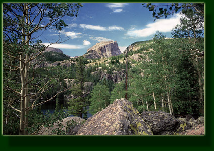
To start out, I walked north along the eastern edge of Bear Lake on
a wide, shaded trail. Many groups of people milled about in the dappled
sunlight. The lake water to the west was calm and still, reflecting Hallet
Peak like a tinted mirror. I stopped and took photographs, though I was
anxious to get moving. As soon as I branched off for Flattop Mt, I suddenly
found myself completely alone. What a difference 400 yards makes! I walked
pleasantly along and took the left fork at the Fern Lake Trail junction.
The trail climbed steeply up through lodgepole pine with several switchbacks.
I was sweating mightily and huffing my way up the trail when the first
clouds came over, softening the shadows of the pine limbs on the trail
at first, then completely blotting them out. Before long the sun came out
again for an interval that grew shorter and shorter between each passing
cloud. I passed several people on the trail in my haste, and they must
have thought I was crazy for going so fast, but I had become aware that
the clouds were apt to bring rain, and rain in the mountains in August
usually brings lightening, and I didnt want to be far from camp when that
showed up.
Gradually the trail broke out above treeline, and at one point I looked
down to see Dream Lake in a chasm far below. I kept moving, and then I
heard the thunder, far off and gentle. I quickened my pace. I met lots
of people coming downhill. To the north the clouds grew like a shadow and
enveloped the Stormy Peaks. I could clearly see the lightening strikes
in the clouds and then I began to see the lightening hit the peaks like
static sparks. The thunder was more a crack than a rumble now, and I was
glad the storm was far north of me. Nevertheless, it was nerve-wracking
being above timberline with lightening around. I decided to stop and lay
low for a little while and see what developed. I found a low spot off the
trail. It as 12:30, and seemingly very early in the day for thunderstorms.
I took my pack off, grabbed an oatmeal-raisin Harvest Powerbar - not very
good) and sat well away from the aluminum frame in a depression surrounded
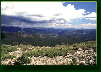
by a few large boulders. The sun was still shining on me, but the storm
to the northeast was terrible. I watched from my eagle perch as the storm
moved slowly into east into Estes Park and darkened it from view. Heavy
rain came down in sheets and lightening pelted the valley helter-skelter.
Once I was sure the storm was well past, I grabbed my pack and dashed uphill.
Once I got to the continental divide, my hopes diminished as I saw a storm
cell coming right at me from the west. I was far from cover going either
forward or backward. I had to decide whether to dash onward or retreat.
I regretted not getting an earlier start to avoid this mess. I dashed onward,
literally jogging most of the way, trying to get lower before the storm
arrived. The trail I was on, leading south along the Continental Divide,
was deserted. I jogged along the thin dirt trail, admiring the magnificent
grandeur of the surrounding peaks in spite of the danger. The rain came
in a fine drizzle at first, and I was lucky in that it was not accompanied
by lightening The trail descended into the Hallet Creek drainage and as
I finally got into the trees and was able to relax. Ironically, the sun
came back out around that time.
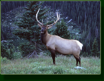
I passed by July camp and two guys were seated by the trail watching
a bull elk graze on aspen not 30 feet off the trail. It seemed wholly unconcerned
about our presence. I watched him chew lazily for a few minutes, then went
on downhill. The jogging had agitated my heels and the balls of my feet,
such that the remainder of the hike was plagued by discomfort. The trail
led steeply down 10 switchbacks that ground my toes into the tips of my
boots with every step and made me long for a little uphill terrain. I reflected
on how easy 10 miles sounded in the backcountry office, not thinking about
the half mile elevation gain and loss that went with it. Despite this,
the beauty and craftsmanship of the trail itself caught my attention. Each
switchback was banked with a short wall of quarried rock, stacked neatly
and covered with moss. Tons of quarried rocks stabilized the trail on the
steep slope, and the grade was wide and smooth. The trails contrasted starkly
with trails in the natural forest which, though they are beautiful in their
simple way, do not compare in sophistication to the trails inside the park.
Most of the trails in Rocky Mountain National Park were built and/or imporoved
by the Civilian Conservation Corp in the 1930's, by men who lived in the
park in tent compounds and earned $1 a day for outdoor work. Not a bad
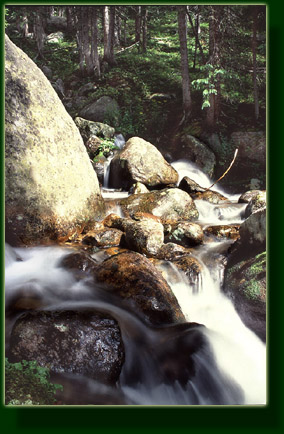
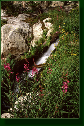
way to spend the Great Depression, I'd say. Near the North Inlet Creek
junction, I stopped at a falls on Hallet Creek and soaked my feet in the
icy water. I lingered here for close to half an hour, enjoying the silence
and solitude. It seemed as if I had chosen a route through the park that
nobody else desired to see. I liked it that way. A new bank of stormclouds
broke me out of my reverie and sent me once again downhill.
I arrived at the North Inlet Creek campground at 3:30 and found it deserted.
I scouted around and determined that site #2 looked the most secluded and
quickly set up my tent. Almost immediately after that, the rain came. I
threw on my rainjacket and hiked back into the woods to hang my food in
the tent bag. The fast-paced hiking had made me forget to drink enough
water, and I suffered from a bad headache. I washed down 600 mg ibuprofen
with 2 liters of cold water. I sank my 16 oz. bottle of Coke in the
small creek nearby, filtered water into the empty bottles, then retreated
inside my tent and took a nap. As I dozed away, the split of lightening
periodically interrupted the gentle sizzle of the light rain falling on
the tent fabric.
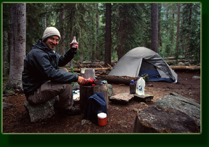
I slept for 2 hours, and got up at 6 for dinner. It was sunny out, so
I draped my wet shirt and socks on nearby spruce branches to dry. The rain
left the air cool, wet and sweet-smelling. I cooked a package of chicken
ramen noodles on the white gas stove and ate it with a few rosemary-tomato
Triscuit crackers. This was excellent. I especially enjoyed the ice-cold
Coke that I brought along. What a treat for a caffeine-addict woodsman!
For dessert I downed about 4 oz of peanut M&Ms, an equal amount of
dry roasted peanuts, and a Little Debbie Starcrunch. Something about long
hikes make me crazy for sweets.
It cooled down after dinner as the sun sank lower and it grew darker.
Mercifully, there were hardly any mosquitoes out and I never felt the urge
to apply bug spray. At 7:00 it was 50F. I cleaned up the dishes, brushed
my teeth and hung the food, then slipped into my warm down sleeping bag
in the tent and read my cheesy Jonathan Kellerman novel for a little while
before falling off to sleep. The woods were perfectly quiet all night long.
____________________________________
August 23 Tuesday
My watch alarm beeped at 4:30 and I got dressed in the dark, shivering.
It was 40F, and a thick layer of dew covered everything outside. The moon
was nearly full, and I was able to locate the hanging bag of food in the
woods and pull down the pre-prepared bag I intended to take with me on
the dayhike. I loaded a few items in my frame pack and set off on the trail
to Nokoni Lake in the dark of pre-dawn at around 4:55. I walked quickly
to keep myself warm. In the thicker sections of forest, I used my little
keychain LED light to see the trail clearly. The air was perfectly calm,
and despite the bright moonlight, the stars were very clear. At high altitude
its almost like theres nothing between you and space.
The eastern horizon lost its blackness at around 5:30, and gradually
gained color. The trail to Lake Nokoni gained 1000 feet over 2.5 miles
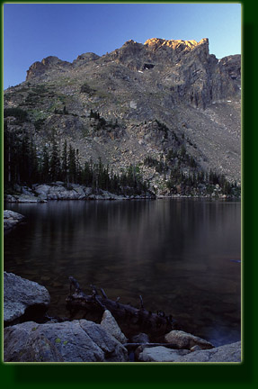
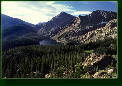
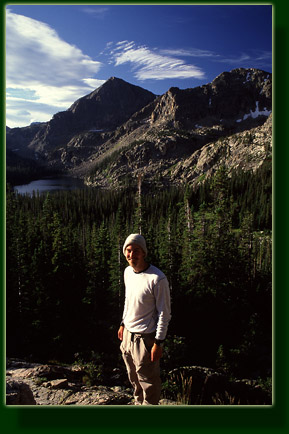
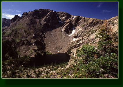
from camp, utilizing many switchbacks. I arrived at the eastern shore at
6:10 in the still, cold twilight, anxiously awaiting the sun. The oily
black water of the lake stretched out in perfect stillness west several
hundred yards to a towering cirque wall almost devoid of trees. The trail
to Nanita Lake continued south through the trees. Nokoni and Nanita are
Arapaho names that predate white settlement. While the Arapaho don't appear
to have lived year-round in the mountains, archeological evidence indicates
that natives hunted and foraged in the mountains seasonally for thousands
of years before white settlers arrived. In 1914, well after the last Arapaho
had been removed from Colorado and sent west to reservations, the Colorado
Mountain Club invited two elderly Arapaho to join them on a survey of the
area as part of the effort to designate it a national park. Many addittional
native names were given to landmarks in the area. Beatiful sounding names
that give flavor to the mountains: Niwot, Neota, Nakai, Mahana, Tanima,
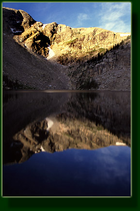
Onahu, Haiyaha, Hiamovi, among others. I set up my camera on the shore
under a sparse canopy of subalpine fir and waited for sunrise to illuminate
the cirque. Because I was on the western edge of the continental
divide, the sun didnt actually hit the cirque until 7:00. Not a cloud
was in the sky as I snapped my camera every few minutes, documenting this
one sunrise of 100 billion this lake will see. I had my fishing pole with
me, but the lack of fish ripples and my enjoyment of taking photographs
compelled me to skip fishing and hike on over to the next lake, Nanita,
at around 7:15.
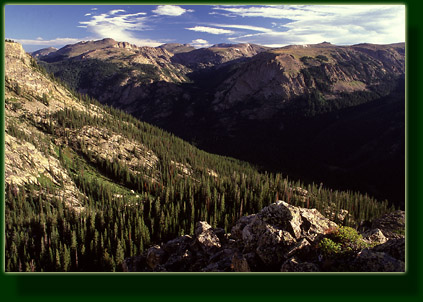
The trail to Nanita led southward up a small hill to a hump that separated
the lakes. Instead of going all the way to the lake, I detoured and climbed
to the top of this hump, from where I could look all the way down, 1200
feet or more, to the camp I had left 4 hours before. The sunlight was brilliant,
star-like, but did not quite negate the chill that the fresh breeze brought.
I found a notch in the rock on the eastern side of the rocky summit, sheltered
from wind, and prepared my breakfast. I added 1 C water to 2C Cocoa Crispies
and 1C powdered milk. Delicious! I sat in the sun and soaked up the warmth,
then snacked on a few peanut M&Ms and Little Debbie Starcrunch..Im
telling you these things are dynamite on a camping trip. Remembering my
folly from the day before, I was sure to drink lots and lots of water.
I could see Lake Nanita in the valley below, and decided to skip it and
head back to Nokoni, where I arrived at 9:15.
The cirque was aglow in sunlight, and I sat by the lake to contemplate
the rock and water. No humans were about. I actually could not discern
any animal life at all around the lake. I filtered water, drank some, filtered
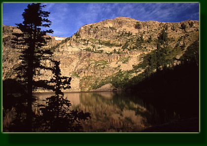
some more. I struck out up the north slope from the lake and gained a flat
plateau about 400 above the lake dotted with fir and spruce. It would
be possible for the daring to continue on above the Nokoni Lake cirque,
and possibly to summit Ptarmigan Peak. I chose not to. I walked to the
north end of this wonderful plateau to see Pettingell Lake, but it was
hidden in a sea of conifers. I walked around the entire perimeter of the
plateau, unshaded under the glowing blue sky, admiring the North Inlet
valley far below and examining as from an airplane the hiking route down
Hallet Creek I had taken the previous afternoon. At one point I examined
the map to find I was standing approximately over the 13.5-mile Colorado-Big
Thompson diversion tunnel, the "Alva Adams Tunnel" that shuttled water
from Grand Lake to the Wind River on the south side of the YMCA of the
Rockies via a 10-foot tunnel completed in 1944. Two crews had drilled the
tunnel from both directions for almost 7 years, and when they finally broke
through they were misaligned by less than half an inch. The project started
in 1937, and the first water flowed east to help irrigate the arid plains
in 1947. Standing high up on the mountain, it was hard to imagine such
a thing existed. I was glad it was hidden undergroun. I sat in the sun
on the grassy, south-facing slope above Nokoni for half an hour soaking
in the sun. At 11:15 it was 55F and breezy, but the breeze was out of the
northwest, so the south-facing slope in the sun was quite cozy. Cognizant
of the potential for early thunderstorms, I began to head back to camp
shortly after, going slowly and taking short breaks to sit and listen to
the sounds of the woods: unseen birds chirping in the firs, creaking boles
of ancient spruces swaying, the occasional chatter of a squirrel starting
at a high pitch and fading away, the soft multi-note chord of wind in evergreen
needles.
I stepped well off the trail around 12:30 and ate a small lunch of triscuits,
cheese and peanut M&Ms. I added Gatorade powder to my water for variety
and to try to ward off headaches due to dehydration. I applied moleskin
to the hotspots on my feet which were still rather sore from the day before.
Near camp, I unfurled my fly rod and fished the North Inlet Creek. I saw
some very small trout flickering about and nabbing at the fly, but none
every hooked.
At 1:15 the clouds rolled in and blotted out the sun. I hightailed it
to camp. I met two guys on the trail, and they were apparently going to
stay at this camp for the night. They were nice, and we discussed the fishing
opportunities briefly. At camp, I hung my food, unloaded my bag and filtered
water. At 1:45, the rain, sleet, lightening and thunder all came as a group,
and I was tickled pink that I was in my tent and not somewhere above treeline.
My early morning rise had paid off, and I decided that would be my schedule
for the rest of the trip. I snoozed under my sleeping bag and then read
my book until the rain ceased at 3:30. I walked about the camp afterward,
stretching my legs. The two fellows from before had set up their camp nearby,
and I could see their brightly-colored tent through the trees. I was thankful
that they were conscientiously quiet the entire time. I debated walking
over and talking with them, but my reclusive nature won out and I stayed
put in camp. At 4:00, I ate dinner of ramen noodles, triscuits, peanuts
and M&Ms with water. It was very cool out from the rain, and even when
the sun came out for a brief appearance around 5PM, it did not warm up
past 50F. I didnt mind too much, as I was ready for bed at 6:00. I packed
as much as I could into my bag so as to facilitate an early start, then
went to bed.
____________________________________
August 24 Wednesday
Following the plan to avoid getting killed by lightening while hiking
at high elevation in the afternoon, I got up with the alarm at 4:30. The
cold, clear sky brought white moonlight streaming down into the clearing
of my camp. Beautiful, and eerie. Everything was silver and black. I dressed
hurriedly in the dark of the tent, and stuffed my sleeping bag and thermarest
into their sacks before getting out of tent. I retrieved the food from
the tree in the woods (no problem finding it in the moonlight). The tent
was dripping with dew, and it would be hours before the sun was out in
strength enough to dry it, so I shook off the fabric as best I could and
stuffed it into its sack soaking wet, like it had just come out of the
washing machine. My hands ached from cold while doing this. At 5:35 I walked
out of camp, noting that a new tent had sprung up along the trail which
I quietly walked around, wondering what its occupant might guess was prowling
around their tent in the wee hours of the morning.
On the shaded trail, I kept my LED light handy to guide me through dark
spots, letting the moonlight do the rest. The switchbacks I had been dreading
since coming down were actually easier going up, and seemed quite pleasant
when hiked on a fresh pair of legs. I stopped several times to strip off
clothing which had been essential in camp but was now suffocating. After
the switchbacks came a long stretch on the north side of Hallet Creek up
to July camp, which I passed at 6:30, just as the sky was turning light
blue overhead. July camp is on the western face of the Continental Divide,
so sunlight doesnt hit there in the morning until perhaps 10 oclock.
I crossed the shallow rushing water of Hallet creek and then began the
switchbacks leading up the south side of the valley. The trail led through
a section of conifers and then punched out above treeline. In the tall
flowers that lined Hallet Creek, I saw a bull moose. He walked slowly away
from me, but did not seem alarmed. I continued on and saw three more bull
elk watching me, motionless, on the trail uphill of me. They too trotted
off away from me. I continued on, watching them stop and stare at me. I
managed the three or four switchbacks up the slope fairly quickly, and
as I neared the top a slight breeze picked up from the west. Even this
slight breeze at 37F chilled me, and I hastened to get to the divide where
the sunshine was sure to warm things up. I stopped and pulled my knit cap
out of my bag and put it on, no longer nearly so warm as I was in the still
air of the conifers. In the quiet, I heard clicking sounds, like hollow
pieces of wood knocking together. At first I assumed it to be noise from
the July camp far below, then I noted that just over a rise in the trail,
I could see the antlers of two elk bobbing and jerking in unison. I slowly
crept forward and witnessed five bull elk on the slope just below the trail,
two of them casually sparring only 30 yards away. All of them were very
large, with 5 points on their antlers. Their necks had taken on the dark
brown mane and their legs were black. Within seconds they were all aware
of me, and the two stopped sparring. Two of the biggest began to walk away,
but the other three just stood and stared. I slowly pulled up my camera
from my shoulder and regretted having only a wide angle lens attached.
Nevertheless I snapped a few shots as I slowly walked nearer to them. Soon,
4 of them were walking away as I slowly walked along the trail. The 5th
elk, one who was originally sparring, stood casually chewing grass and
glancing around. He seemed pretty relaxed, so I did too. I walked past
him and snapped a few more shots. Then, realizing how cold I had gotten
just standing there for so long, I hastened uphill, feeling very cold.
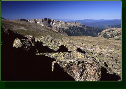
The trail led out of the valley and onto the flat tundra of the divide.
The sun was shining in a brilliant yellow light on the rocks and I picked
out a large one well off the trail to have breakfast on at 8:00. Facing
the sun, I added water to my powdered milk and cereal and wolfed it down,
followed by a vanilla power bar and a Starcrunch (cant get enough of those).
Back on the trail, I felt great and it was early, so I decided to take
a detour and explore Loch Vale from above. Ive always thought Loch Vale
was one of the prettiest names in the Park. The going was easy, as it was
mostly flat and there were no obstacles to obscure the route. I aimed for
the lowest point between Otis Peak and Hallet Peak to begin with, and reached
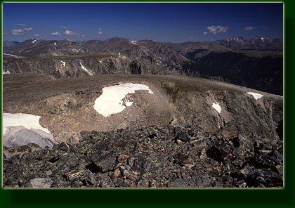
it in a driving west wind. From the edge of the precipice, I looked down
into Chaos Canyon and Lake Haiyaha beyond. I stowed my pack near a group
of rocks and took off with my camera towards Otis Peak. I entertained thoughts
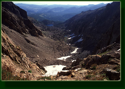
of climbing it, but the wind convinced me not to. Instead I picked my way
across the jumble of boulders on the south side of Otis Peak and came out
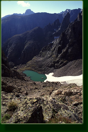
just above Andrews Glacier. A remarkable scene presented itself. Ive hiked
quite a lot in Colorado, but this seemed more like Montana than any scenery
in Colorado I have seen before. The deep glacier cirque held a long glacier
that fed into a tiny greenish tarn that shimmered in the sunlight. On the
far side of the hanging cirque rose a sharp pillar of rock called the Sharkstooth.
Thatchtop Mt rose up darkly behind that, and on the horizon stood the anvil
head of Longs Peak. Wonderful. I dropped down below the lip of the cirque
and found shelter from the wind behind a mound of rock. As on the day before,
the south-facing slope out of the wind was very cozy, and I lingered for
quite some time in the solitude and quiet. I looped around further west
on the way back, and gathered my pack before heading towards Hallet Peak.
I stopped along the way to change my socks which were damp with perspiration.
Here again I stashed my pack in the rocks, grabbed a water bottle and my
camera and walked to the top. Several others were at the summit, and one
of them graciously took my photo. The wind was brisk, but the sun tempered
the coolness. From the summit I could look back toward Ptarmigan Peak and
pick out the plateau I had spent the previous morning on. In all directions,
alpine splendor abounded under the bright morning sun. Intoxicated with
the sweet thin air, I felt infinitely energetic, even after hiking 2800
uphill for 6 miles. Enos Mills, an early booster of the Park, wrote in
1917, "From wilderness the traveler returns a man, almost a superman."
There on the summit of Hallet Peak I reached the zenith of physical well-being
for the year. I just felt great, and thats the best reward.
From that highpoint of 12, 713, I retraced my steps downslope to my
pack, strapped it on and hiked along to meet up with the Flattop Mt Trail,
nibbling on peanuts. The Flattop trail was sustaining heavy traffic, and
I stepped off of it often to allow those going uphill to pass by. All sorts
of personalities are encountered on the trail, from those who ignore you
completely, to those who not only smile and nod but stop to chat. There
are those who are clearly miserable, sweating and grunting their way uphill
without thought for a rest break, and then there are those who wear their
pleasure on their faces in a permanent smile, unbroken by heavy breathing
or harsh sunlight. At different times, I have been all of these people,
and they have probably shown all sides as well. The heavy traffic on this
trail high above timberline presented one large problem: there is nowhere
to stand unseen to relieve the bladder, and rarely an interval between
hikers long enough to allow privacy. I held it long, but my insistence
on drinking plenty of water all morning necessitated a pit stop. I chose
my interval carefully, and stepped off the trail 10 feet. Nobody came along.
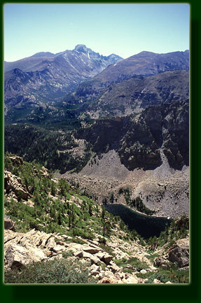
The weather was more fair than the day before, and as noon approached,
the sky remained non-threatening. I stopped at the switchback over Emerald
Lake, just below timberline, for a lunch of tuna and crackers with a few
squares of chocolate bar. The sun was warm and I dried my socks on a nearby
spruce branch while I took a short nap. In the distance, Longs Peak dominated
the landscape.
The trail led back down into the large conifers, and I began to feel
a bit drowsy and fatigued. At 1:30 I reached the junction with the Fern
Lake Trail, and instead of heading back to the car, turned back west to
walk back uphill to Odessa Lake, which is where I spent the third and final
night of the trip. The narrative for that portion of my wonderful summer
vacation is continued on the next page. |