| Location: Comanche Peak
Wilderness, Roosevelt National Forest, Colorado
Maps: Trails Illustrated 1:40K: Cameron Pass #112; USGS 7.5' Comanche Peak, Kinikinik Access: From Ted's Place at the Poudre Canyon entrance on CO14, drive 25.7 miles west on Hwy 14 and turn south on the well-marked Pingree Park Road (63E). Turn west after 4.2 miles onto 139, Crown Point Road. Drive west on the well-graded road about 15 miles to the Browns Lake TH. My Toyota Corolla made it with no problem, however, this road maintains snow late into the spring and early summer. Trailhead: NAD83 zone 13 440939e 4500079n Elevation: 10,500' Fees: None Trail: 4mi one-way to Browns Lake, can connect with numerous trails in the area. Moderate hike since it is steep in placesand at high altitude. Do not attempt if threat of lightening exists as most of the hike is above timberline. Dog Regulations: 6' leash control Webcam: Pingree Park 6 miles southeast (spring-fall only) Weather: NOAA weather station Local Forecast 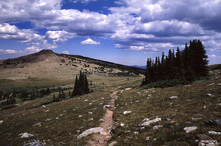 August
8-9, 2005 August
8-9, 2005
The road to the Browns Lake trailhead, Crown Point Rd, reaches a surprisingly high elevation of 10,400` as it winds upward from the Pingree Park Rd to just below timberline. Frank panted in the backseat as I slowed the car and turned into the parking lot where just two cars waited for their owners to return. I parked and packed as quick as I could, exchanging my sandals for wool socks and boots. The day was beautiful, though the thick cumulous clouds sliding by just above me at only 10AM hinted that rain was coming before the day was through. Frank and I walked across the dirt road to the trailhead and started uphill into the trees. The trail was steep, and there was an uncanny lack of breeze on this morning. Consequently I was soaked with sweat by the time we broke out above treeline 30 minutes later. From that point on, I almost never lost sight of the Rawahs to the west. This hike offered by far the best view of the Rawahs I have ever seen, and I only wish that the sun had stuck around long enough to get some really nice photographs of them. Unfortunately, the sun that had sent slanting shadows across the dirt road on my drive up was hidden from view for most of the hike, and the landscape cloaked in a cool and drab gray of cloud-filtered light. I paused often to admire the Rawahs, and to catch my breath on this rather steep stretch. A woman and a young boy, presumably her son, hiked downhill past Frank and I. My first backpacking trip didnt occur until I was 19, and here this kid gets to enjoy it at age 10. He undoubtedly has no idea how lucky he is to be growing up within striking distance of some of the most beautiful mountains in the country. When I was 10, I had no inkling that I would ever see Colorado at all, much less hike its mountains alone. What lies ahead in life that I cant imagine? I reached the top of the ridge that holds Crown Point (11,460`), a ragged jumble of barren rocks that reminds me of how I always pictured Weathertop to be in the Lord of the Rings before the movie came out and showed me Peter Jacksons vision of it. From this point, my heart sank a little as I could see the trail lead straight down into the grassy valley below, then straight back uphill to the distant ridge. With a heavy pack, I always take great pains to avoid losing elevation, and this trail seemed to be a bit masochistic in its route. Thus it was with a little joy that I quickly noted the new route, constructed by the Colorado Mountain Club in the early 1980s, that pioneered a more level path to the south of the old trail that did not relinquish much elevation on its  way
to the next ridge. Good. Late-season grass covered the smooth terrain,
with pockets of bluebells and other cushion plants with spent flowers.
The valley sloped down to the west, framing the Rawahs in the distance.
At the top of the second ridge, I looked down and saw trees gradually increasing
in height as they bore downhill. In the distance, steep cliffs glowed dully
in the blue light, and I knew that at the base of those cliffs, hidden,
lay Browns Lake. The trail led straight downhill into the trees. Not quite
ready to give up my tundra hiking views, I decided to go off trail and
follow the ridge I was on to the west and, after consulting my map, to
link up with the Flowers Trail at the head of the Browns Lake cirque.
I headed off on the ridge and the sun came out for brief appearances, warming
my back and lightening the mood. I stopped for some water at a rock outcropping
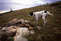
and tried to dribble some for Frank without letting him actually lick my
water bottle (Ive seen some of the crap he eats in the woods
why is elk
poop so desirable, I wonder?). Hes not very good at this, although he
seems to do very well with a water stream sprayed from a Camel Back. As
the ridge descended towards the Flowers Trail, I caught side of it ascending
uphill beyond the head of the cirque, and angled my route to that point.
This direction led us into short scattered spruce trees, then taller spruce
trees in islands before dumping us out onto a grassy plain at the head
of the cirque. I shucked off my pack and sat on a rock that overlooked
Browns Lake 600` below me to the southeast, and Timberline Lake just below
that. In the distance, I could just make out the muddy flats surrounding
a much-reduced Comanche Reservoir. To the south, clear from almost anywhere,
was the imposing barren massif of Comanche Peak, for which this particular
wilderness area is named. I downed some water and chocolate, and studied
the map for quite some time. After seeing these spots on the map for years,
I mentally compared what I imagined them to look like with what they indeed
did look like. I imagined Browns Lake to be more open, not so penned-in
by surrounding cliffs and slopes. The area surrounding Browns Lake
is a Travel Zone, meaning that camping is restricted to designated sites
only. Noting how boxed in the lake seemed, and not wanting to get boxed
in, I decided to camp where I was, outside the Travel Zone and therefore
free to camp wherever. I backtracked up the hill some ways until I was
well away from the trail, and then selected a spruce tree cove with a flat,
needle-laden floor. I set up the tent and unloaded my gear, then hung my
food way
to the next ridge. Good. Late-season grass covered the smooth terrain,
with pockets of bluebells and other cushion plants with spent flowers.
The valley sloped down to the west, framing the Rawahs in the distance.
At the top of the second ridge, I looked down and saw trees gradually increasing
in height as they bore downhill. In the distance, steep cliffs glowed dully
in the blue light, and I knew that at the base of those cliffs, hidden,
lay Browns Lake. The trail led straight downhill into the trees. Not quite
ready to give up my tundra hiking views, I decided to go off trail and
follow the ridge I was on to the west and, after consulting my map, to
link up with the Flowers Trail at the head of the Browns Lake cirque.
I headed off on the ridge and the sun came out for brief appearances, warming
my back and lightening the mood. I stopped for some water at a rock outcropping
and tried to dribble some for Frank without letting him actually lick my
water bottle (Ive seen some of the crap he eats in the woods
why is elk
poop so desirable, I wonder?). Hes not very good at this, although he
seems to do very well with a water stream sprayed from a Camel Back. As
the ridge descended towards the Flowers Trail, I caught side of it ascending
uphill beyond the head of the cirque, and angled my route to that point.
This direction led us into short scattered spruce trees, then taller spruce
trees in islands before dumping us out onto a grassy plain at the head
of the cirque. I shucked off my pack and sat on a rock that overlooked
Browns Lake 600` below me to the southeast, and Timberline Lake just below
that. In the distance, I could just make out the muddy flats surrounding
a much-reduced Comanche Reservoir. To the south, clear from almost anywhere,
was the imposing barren massif of Comanche Peak, for which this particular
wilderness area is named. I downed some water and chocolate, and studied
the map for quite some time. After seeing these spots on the map for years,
I mentally compared what I imagined them to look like with what they indeed
did look like. I imagined Browns Lake to be more open, not so penned-in
by surrounding cliffs and slopes. The area surrounding Browns Lake
is a Travel Zone, meaning that camping is restricted to designated sites
only. Noting how boxed in the lake seemed, and not wanting to get boxed
in, I decided to camp where I was, outside the Travel Zone and therefore
free to camp wherever. I backtracked up the hill some ways until I was
well away from the trail, and then selected a spruce tree cove with a flat,
needle-laden floor. I set up the tent and unloaded my gear, then hung my
food 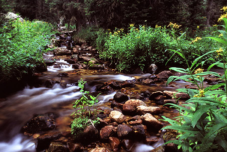 nearby.
With my pack reduced in weight to the bare essentials, I returned
to my previous overlook point and caught the Flowers Trail uphill. The
sun was out again in full blast mode, and the hike uphill was hot. I passed
two fellows with day packs, and we both agreed that we all had no destination,
just wandering. It was a good day for that. Before several hundred yards
were up, I felt I was being led away from the aerial views of Browns Lake
I craved, so I ditched the trail and headed east to the cliffs on the south
side of the lake. I was rewarded with the amazing overhead vantage I was
looking for, photographed it, admired it, and then walked along the cliffs
to the south until I reached timber, at which point I cut straight south
over 1000` down the steep, downed-timber-littered slope to the Beaver Creek
trail. I would not recommend this route, as it is extremely steep, and
you need wings to get over the massive amount of dead logs blocking ones
way. I would have arrived much sooner to the Beaver Creek trail by simply
following the Flowers Trail to the junction with Beaver Creek. Nevertheless,
the Beaver Creek trail on this stretch is one of the most scenic trails
Ive ever been on, and I enjoyed it immensely. The sun came out in stretches
and sent shadows across the path, and ignited gleaming flecks in the rippling
water of the creek. Frank trotted along in front of me, happy as Ive ever
seen him. We walked downhill to the junction of the Comanche Lake
Trail. The clouds were getting thicker, and by now had come to stay. I
risked getting caught far from camp in a downpour, but I risked all (but
really not much) and headed uphill to Comanche Lake. Being so remote, I
was surprised to find two fellows fishing the lake when I arrived. I sat
down at the north side (outlet) of the lake and had a snack. Frank did
the same. I then pieced together my fly rod and attempted to trick one
of the large cutthroat trout gliding along in the sandy shallows of the
lake. I had a few strikes, but did not hook anything long enough to get
it to shore. A brief shower came through, and I retreated into the timber
to lessen the drenching of my clothes. No sooner had I donned my rainjacked
when the rain left. Back to fishing. I moved around to nearby.
With my pack reduced in weight to the bare essentials, I returned
to my previous overlook point and caught the Flowers Trail uphill. The
sun was out again in full blast mode, and the hike uphill was hot. I passed
two fellows with day packs, and we both agreed that we all had no destination,
just wandering. It was a good day for that. Before several hundred yards
were up, I felt I was being led away from the aerial views of Browns Lake
I craved, so I ditched the trail and headed east to the cliffs on the south
side of the lake. I was rewarded with the amazing overhead vantage I was
looking for, photographed it, admired it, and then walked along the cliffs
to the south until I reached timber, at which point I cut straight south
over 1000` down the steep, downed-timber-littered slope to the Beaver Creek
trail. I would not recommend this route, as it is extremely steep, and
you need wings to get over the massive amount of dead logs blocking ones
way. I would have arrived much sooner to the Beaver Creek trail by simply
following the Flowers Trail to the junction with Beaver Creek. Nevertheless,
the Beaver Creek trail on this stretch is one of the most scenic trails
Ive ever been on, and I enjoyed it immensely. The sun came out in stretches
and sent shadows across the path, and ignited gleaming flecks in the rippling
water of the creek. Frank trotted along in front of me, happy as Ive ever
seen him. We walked downhill to the junction of the Comanche Lake
Trail. The clouds were getting thicker, and by now had come to stay. I
risked getting caught far from camp in a downpour, but I risked all (but
really not much) and headed uphill to Comanche Lake. Being so remote, I
was surprised to find two fellows fishing the lake when I arrived. I sat
down at the north side (outlet) of the lake and had a snack. Frank did
the same. I then pieced together my fly rod and attempted to trick one
of the large cutthroat trout gliding along in the sandy shallows of the
lake. I had a few strikes, but did not hook anything long enough to get
it to shore. A brief shower came through, and I retreated into the timber
to lessen the drenching of my clothes. No sooner had I donned my rainjacked
when the rain left. Back to fishing. I moved around to 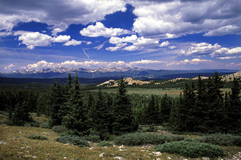 the
literal outlet of the lake, since the other two fellows there were fishing
the inlet. About a hundred logs were jammed at the outlet, all seemingly
quite sturdy. In order to get to open water, I hopped along on some of
the larger dry logs until I was near open water. I spotted a large fish,
and cast out just for him. He obliged by violently striking the fly and
I managed to hook him by a well-time flick of the wrist. I started to pull
him in, and noted that he was thrashing around much more than typical.
Being a big fish, I gave himplenty of latitude, and brought him in slow.
As he neared the logs, I began to realize that without a net (which I rarely
carry on backpacking trips), I was going to have a difficult time landing
him from my precarious perch. Each time he got close, I would try to grab
him, and this would send him off into a frenzy of splashing. On the third
such attempt, I tried to get closer by stepping down onto a lesser log.
Mistake. I might point out that Vibram soles are like greased lightening
on wet, algae-covered logs. My right foot went right in up the calf. I
pulled it out, soaking, cursing to myself, and eyeing the fellows who were
eyeing me from the opposite shore. Yes, gentlemen, here is your afternoon
entertainment. They didnt seem to be having much fish action up there,
so Im sure I was quite the spectacle of the moment. I laid my pole across
several logs and quickly pulled off my boots and socks and threw them 20`
to shore. Then I waded in after my fish. When I had laid my pole down,
this wily fish had taken the opportunity of extra slack line to weave the
leader in and around about a dozen logs. I had to search for several seconds
amongst the logs to find him. When I did, I grabbed him securely, cut the
line just above the fly, and took him to shore where he was quickly put
out of his panic. After retrieving the line and pole, I packed up fish,
gear and re-booted my feet before heading downhill. The fish was a 12"
Colorado Cutthroat, according to the beautiful illustrations on my Colorado
Fishing Regulations Guide. I made it downhill to Beaver Creek in very little
time. The sky was very overcast and threatening, so I decided not to stop
and filter water, even though I was a bit thirsty. I speculated I could
take the Browns Lake trail and be at water again in no time. This wasnt
quite the case, and I ended up laboring uphill on a trail much longer than
I had anticipated with no water. By the time I reached Timberline Lake
I was quite parched, and drank water straight from the filter tube when
I reached the outlet creek. The water was warm and had a bitter taste to
it, so I the
literal outlet of the lake, since the other two fellows there were fishing
the inlet. About a hundred logs were jammed at the outlet, all seemingly
quite sturdy. In order to get to open water, I hopped along on some of
the larger dry logs until I was near open water. I spotted a large fish,
and cast out just for him. He obliged by violently striking the fly and
I managed to hook him by a well-time flick of the wrist. I started to pull
him in, and noted that he was thrashing around much more than typical.
Being a big fish, I gave himplenty of latitude, and brought him in slow.
As he neared the logs, I began to realize that without a net (which I rarely
carry on backpacking trips), I was going to have a difficult time landing
him from my precarious perch. Each time he got close, I would try to grab
him, and this would send him off into a frenzy of splashing. On the third
such attempt, I tried to get closer by stepping down onto a lesser log.
Mistake. I might point out that Vibram soles are like greased lightening
on wet, algae-covered logs. My right foot went right in up the calf. I
pulled it out, soaking, cursing to myself, and eyeing the fellows who were
eyeing me from the opposite shore. Yes, gentlemen, here is your afternoon
entertainment. They didnt seem to be having much fish action up there,
so Im sure I was quite the spectacle of the moment. I laid my pole across
several logs and quickly pulled off my boots and socks and threw them 20`
to shore. Then I waded in after my fish. When I had laid my pole down,
this wily fish had taken the opportunity of extra slack line to weave the
leader in and around about a dozen logs. I had to search for several seconds
amongst the logs to find him. When I did, I grabbed him securely, cut the
line just above the fly, and took him to shore where he was quickly put
out of his panic. After retrieving the line and pole, I packed up fish,
gear and re-booted my feet before heading downhill. The fish was a 12"
Colorado Cutthroat, according to the beautiful illustrations on my Colorado
Fishing Regulations Guide. I made it downhill to Beaver Creek in very little
time. The sky was very overcast and threatening, so I decided not to stop
and filter water, even though I was a bit thirsty. I speculated I could
take the Browns Lake trail and be at water again in no time. This wasnt
quite the case, and I ended up laboring uphill on a trail much longer than
I had anticipated with no water. By the time I reached Timberline Lake
I was quite parched, and drank water straight from the filter tube when
I reached the outlet creek. The water was warm and had a bitter taste to
it, so I 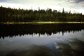 decided
to wait for more filtering until I found a better water source. Just
upstream, I fished a small pool below Timberline Lake and caught about
6 brook trout, although all but one was too small to consider keeping.
I followed the stream to Timberline Lake, fished it with no success, then
continued around its southern shore to Browns Lake, which I fished through
a short rainshower with no catches. On the northern bank of Browns Lake,
getting on towards 7PM, I cooked some Ramen noodles and gave Frank some
kibbles. I filtered water from Browns Lake, which also didnt taste very
good, then fished until I had 3 additional good-sized Brook trout in my
bag. At 8PM, under foreboding skies, I left Browns Lake to the mosquitoes
and headed uphill in the gathering gloom towards the junction with the
Flowers Trail. I was worried that as dark as it was getting I would miss
the turnoff, but it was well marked and I had no trouble finding it, though
I would have had trouble reading a map at that point. Heading west, I passed
the remains of a cabin and pondered how sickeningly isolated that would
be in the wintertime, packed in by 20` of snow. At around 9 I reached camp,
in almost total darkness. Frank was exhausted, and immediately set to creating
his own little bed under the spruce trees by circling round and pawing
at the ground. I opened up the tent for him, and seeing his opportunity,
he slipped right in and laid down. I gathered my food to add to the hanging
bag. I put the fish in the ziplock bag in my water filter bag and soaked
the bag with water. I hung everything between two spruce trees. I hoped
the evaporative cooling of the water on the bag would keep the fish cool
enough overnight. While I was hanging the food, a herd of elk galloped
through the trees nearby. In the dark, on a still night, the noise was
deafening, and initially very frightening until I realized what it was.
Frank didnt bother to investigate, and remained unmoved on my sleeping
bag in the tent. I slept very well that night. decided
to wait for more filtering until I found a better water source. Just
upstream, I fished a small pool below Timberline Lake and caught about
6 brook trout, although all but one was too small to consider keeping.
I followed the stream to Timberline Lake, fished it with no success, then
continued around its southern shore to Browns Lake, which I fished through
a short rainshower with no catches. On the northern bank of Browns Lake,
getting on towards 7PM, I cooked some Ramen noodles and gave Frank some
kibbles. I filtered water from Browns Lake, which also didnt taste very
good, then fished until I had 3 additional good-sized Brook trout in my
bag. At 8PM, under foreboding skies, I left Browns Lake to the mosquitoes
and headed uphill in the gathering gloom towards the junction with the
Flowers Trail. I was worried that as dark as it was getting I would miss
the turnoff, but it was well marked and I had no trouble finding it, though
I would have had trouble reading a map at that point. Heading west, I passed
the remains of a cabin and pondered how sickeningly isolated that would
be in the wintertime, packed in by 20` of snow. At around 9 I reached camp,
in almost total darkness. Frank was exhausted, and immediately set to creating
his own little bed under the spruce trees by circling round and pawing
at the ground. I opened up the tent for him, and seeing his opportunity,
he slipped right in and laid down. I gathered my food to add to the hanging
bag. I put the fish in the ziplock bag in my water filter bag and soaked
the bag with water. I hung everything between two spruce trees. I hoped
the evaporative cooling of the water on the bag would keep the fish cool
enough overnight. While I was hanging the food, a herd of elk galloped
through the trees nearby. In the dark, on a still night, the noise was
deafening, and initially very frightening until I realized what it was.
Frank didnt bother to investigate, and remained unmoved on my sleeping
bag in the tent. I slept very well that night.
|
| Page created Nov 17, 2005
Comments |
 I
set my alarm for 5:30 in order to watch the sunrise on the Rawahs. At 5:30
I poked my head out of the tent and noticed no stars at all, a sign that
the clouds were still socked in. In some small way I relished this excuse
to sleep in as late as I desired, and promptly went back to sleep. The
sun shone in my eyes around 7:30, waking me. I got up, and walked around
camp, deciding what to do with this day. The sky was still very cloudy,
and by 8:00, the sun was gone, apparently for good. Noting the forboding
clouds so well-developed so early in the morning, I decided spending this
day at or above timberline would be unwise. Thus, I packed up camp and
retreated to the trailhead following the route I had taken on the way in.
It was cool, and rain came down in two separate but short showers. I saw
nobody on the way down, and when I left the parking lot, there were no
cars remaining.
I
set my alarm for 5:30 in order to watch the sunrise on the Rawahs. At 5:30
I poked my head out of the tent and noticed no stars at all, a sign that
the clouds were still socked in. In some small way I relished this excuse
to sleep in as late as I desired, and promptly went back to sleep. The
sun shone in my eyes around 7:30, waking me. I got up, and walked around
camp, deciding what to do with this day. The sky was still very cloudy,
and by 8:00, the sun was gone, apparently for good. Noting the forboding
clouds so well-developed so early in the morning, I decided spending this
day at or above timberline would be unwise. Thus, I packed up camp and
retreated to the trailhead following the route I had taken on the way in.
It was cool, and rain came down in two separate but short showers. I saw
nobody on the way down, and when I left the parking lot, there were no
cars remaining.