Location:
Rawah Wilderness, Colorado
Trail: The trail stays
in timber most of the way, is typically steep, and is about 8 miles from
trailhead to Carey Lake. Snow remains on the trail through July.
Maps: USGS 7.5' Quads:
Boston
Peak, Rawah Lakes, Clark
Peak (1:24K). Trails Illustrated #112 Poudre River/Cameron Pass (1:40K)
Access: From Ted's Place
at the entrance to Poudre Canyon, drive 51 miles west on Hwy 14 to the
Laramie River Rd, 2 miles west of the Big South TH. Go north for about
7 miles to the West Branch TH.
Trailhead: NAD83 zone
13 427838e 450.471n Elev: 8560'
Fees: None
Dogs: Officially, it's
leash control here (But WWThoreauD?)
Weather: Current
and recent conditions Local
Forecast
June 30 - July 2
Andra and I left work early on a Friday to
take full advantage of the holiday weekend, and by 6:00 we were at the
West Branch trailhead. It was sunny and warm, almost hot, as we merrily
hiked along the Laramie River for ¼ mile before the route divided,
with the right fork continuing on as a two-track road along the Central
Supply Ditch (a great bike ride) and the left leading uphill as a footpath
into the wilderness. We crossed a bridge over the supply ditch, which
was running swiftly with clear water, and followed the muddy trail up through
a screen of spruce where the trail forked again, with the left branch leading
down to the Tunnel campground, and the right fork leading uphill. and into
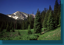
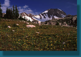
an open dry meadow of aspen. We reached the Rawah Wilderness boundary almost
immediately, and continued on through a beautiful thick forest, lush with
wildflowers and humming with vibrancy. The roar of the West Branch of the
Laramie River was audible just to the south of the trail, but for the most
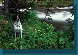
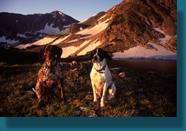
part the water was unseen through the trees. Makenzie and Frank, adult
pointers, were in the lead, sniffing about and trotting happily in front.
Andra walked behind them and I followed in the rear, slogging in the mud.
The air was humid and before long, the mosquitoes showed up. We stopped
as soon as they were noticed to apply bug spray. Nothing worse than deciding
the apply deet after youve already been bitten 30 times. With packs back
on, we continued on for about an hour until somewhere just shy of the junction
with the Camp Lakes Trail where we walked off the trail to seek suitable
camping ground for the night. Initially we walked north through an aspen
grove, but the ground was soggy everywhere, and we were soon back on the
trail with mud covering our lower pant legs. We then walked south towards
the river, which by now was in a deep canyon below, and we found a nice
flat area whose only drawback was close proximity to the trail. We reasoned
(correctly, it turned out) that nobody else was likely to be by this section
of trail this night, and we would be well on our way by the time anybody
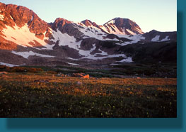
starting from below came by in the morning. Thus, we pitched the tent in
the gathering dark, cooked a quick dinner, and hopped in our new tent.
Only a few feet away, the rock dropped off almost vertically several dozen
feet to the water roaring by below. After years of sleeping with two large
dogs and two humans in a "2-man" Kelty tent, Andra finally convinced me
earlier in the spring that we needed to upsize in the name of comfort.
Accordingly, we bought a nice 2-pole Mountainsmith 3-man tent that is quite
roomy and, amazingly, lighter than the Kelty 2-man. Thus, this was our
first night sleeping in the relative comfort of the larger tent.
In the morning we woke early, refreshed from
our decent nights sleep in the large tent. We packed up our stuff and
set off in the warm morning air. The sun was shining brightly, and it didnt
take long for puffy white clouds to appear that were quickly taking on
all the trappings of thunderheads. We quickly passed the right hand cutoff
for Camp Lakes, and later took the left fork at the Rawah Trail junction.
The trail was long and steep, and hours went by in a rhythmic hiking trance
through the unbroken woods. We stopped at 11:00 near the junction with
the Blue Lake Trail and had a snack of cheese, sausage and crackers. We
filtered water in the clear stream near the trail, and warmed our sweat-soaked
backs in the sun. We did not see any hikers on the trail the entire morning.
After the junction with the Blue Lake Trail, the route seemed to get significantly
steeper, and we slowed considerably. Years ago, Andra, Frank and I had
backpacked up to Twin Crater Lakes, the next drainage north, and foolishly
camped above treeline. During the night, a ferocious thunderstorm floated
over and racked the mountains with lightening. Speaking for myself, it
was the highest level of fear Ive ever felt, and the closest I think I
ever was to death. I vowed never to camp above treeline again, and so we
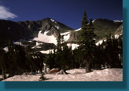
stopped well shy of Carey and Island Lakes, both just above 11,000 ft,
and camped at about 10.500 in the relative safety of thick, tall spruce
trees. We found ourselves a nice camp well away from the trail, yet near
a side stream, and set up camp. Once everything was secure, we decided
to hike up to the lakes. It was around 1:00 and we figured we had plenty
of time before the threat of afternoon showers turned into reality. The
sky was still more clear than cloudy, but it was changing fast. Andra,
Frank, Makenzie and I made the heart-pounding walk up to the lake in about
30 minutes. As the trail nears the lakes, it sort of evaporates into the
tundra, so youre more or less on your own once you hit treeline. We headed
too far to the south, and hit Island Lake straighaway, though I was aiming
for Carey Lake. Both lakes, naturally, are pristine and beautiful as only
a wilderness mountain lake can be. There is very little that compares in
beauty, in my opinion. We walked down to the shore of Island Lake and sat
near the water. The wind was whipping and the clouds conspired to seal
off the sky from the sun completely. We didnt tary long, but it was too
long, and before we were halfway back to camp, the rain came in bloated
freezing drops. Having been caught in rain before, we were ready for it,
and slipped on our rainjackets upon the first drops and cinched the hoods
tight. The trail, already wet, flowed like a stream. The dogs quickly became
soaked, and we hurried down as fast as we dared to try to minimize their
exposure. They are both shorthaired pointers, and both very skinny. Consequently,
they do not take rain or cold very well at all, Frank especially. Back
at camp, we all hopped in the tent without much coordination, and the wet
dogs soon spread their wetness to all things. We dried them with our merely
damp shirts as best we could, then we all lay under down sleeping bags
while Andra and I read our books. A steady drone of raindrops pelted the
tent like pebbles for over an hour. When the rain abated, I happily exited
the cramped tent and puttered around outside. I hung a line between two
trees and hung up our wet clothes. The sun came out, but without enthusiasm
enough to dry anything well. Still, the sunlight was enough to coax Andra
and the dogs out of the tent, and we pulled out our sleeping bags and pads
that had been soaked by the dogs and positioned them to maximize the drying
power of the sun, while it lasted. We cooked an early dinner, for fear
of more rain coming along, and ate happily. Most of the sleeping gear dried
nicely, but the cotton T-shirts remained stubbornly wet. I was pleased
to note the makers of our tent included a hanging line around the top of
the tent that worked great for hanging damp clothes overnight. Whether
they actually dried any overnight in the damp, cold air of the tent is
hard to say, but it seems better than trying to dry them outside of the
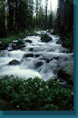
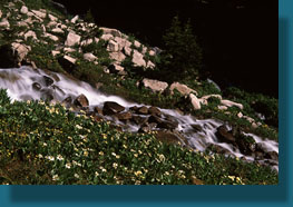
tent. As the afternoon waned, we all went for a short walk along the fledgling
Laramie River, which is more of a perpetual waterfall in this area, and
crashes from shallow pool to shallow pool in a raucous festival of whitewater
that is very entertaining. The grass and tall daisies were dripping with
water, and within a few steps everyone was pretty wet. Andra and I had
our rain pants on, but the dogs had nothing, and we grimaced at the thought
of having to dry them off again. Someone needs to invent raingear for dogs.
Despite this, the afternoon light slanting through the dripping spruce
boughs gave the forest a dreamy, fairy-like quality. Plants seemed to pour
out of soil like water, and every surface was covered with green. The rain
had brought green moss to life on every rock, making them at once colorful
and treacherous to walk on. Every now and again, the weather serves to
remind one that Vibram soles are absolutely useless on wet rock. Back at
the tent, we snacked on M&Ms, then piled in the tent as the sun sank
low behind the mountain ridge to the west. Having napped for a good portion
of the afternoon, nobody, especially Makenzie, was tired. So, although
Frank fell promptly off to sleep, buried beneath Andras down bag, the
rest of us stayed up reading late in the night, and I attribute the extended
period of laying on my stomach, propped up on my elbows, for the terrible
pain in my back that would haunt me for 2 weeks after.
At 5:30 the following morning, my alarm went
off. I dressed quickly in the freezing dark, and then said adios to Andra,
barely awake and trying to be asleep again. Frank, Makenzie and I piled
out of the tent and hoofed it up the trail. In the dim light, I passed
by a group of tents near the trail that were not there the afternoon before.
My goal was to make it back up to Island and Carey Lakes at about the same
time as the sun, and I knew as soon as I got going that I was already behind.
I hiked as fast as my heart would allow, but the trail is quite steep,
and I marveled at Frank and Makenzie who bounded up the trail and back
down to me, time and again, with the greatest of ease. Although I was speedy,
I did not make it to the lakes at the instant the orange sunlight hit the
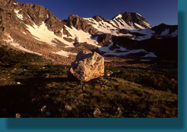
granite peaks behind them as I had originally planned. I made my way to
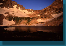
Island Lake first, and set up my camera to take photographs of the still
lake surface and the orange rock behind. We three then hiked up to the
highest point to the east of Island Lake, where I took more photos of the
lake and then spent some time setting up the dogs for a timer-released
group photo of all. My trick is to interest the dogs in a rock, make them
sit about 15 feet from the camera, and then start the timer and run to
them. An instant before the timer releases, I throw the rock right over
the camera and they naturally watch it go just as the camera shutter releases
and we are all apparently looking right at the camera. This usually works.
The only hitch is that occasionally Makenzie forgets that she is supposed
to be staying put (so young), and launches herself after the rock as soon
as it is thrown, resulting in many memorable photos of me, Frank and a
brown blur in the area of Makenzie. My next goal was to walk north of Carey
Lake and check out both lakes from that angle. Crossing the outlet of Carey
Lake was a little tricky, as the water is fairly high, but I managed it
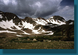
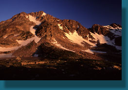
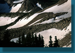
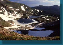
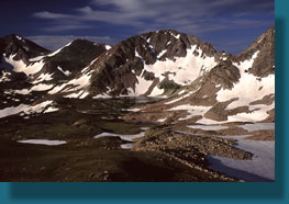
without getting my socks wet. Both lakes sit in a cirque with the highest
side to the west, which is virtually insurmountable. But the north side
of the cirque is easily climbable and reaches a very respectable height.
I set off up the grassy tundra in the shade and was soon huffing and puffing
and switch-backing up the steep grade. If the surface were rock, this would
not be possible. Once again, I marveled at Frank and Makenzie zipping up
and down the 50 degree incline while I huffed and puffed for every foot.
I finally reached sunlight after several hundred feet hard climbing and
sat down to admire the lakes. I like to keep my back turned to the view
and purposefully climb higher and higher to delay the gratification of
looking behind me until the gratification is mind-blowingly gratifying.
This was no disappointment. The view from this location is among the best
in the entire Rawahs. After catching my breath, I decided to climb higher,
and being so impressed with what I could see when I got there, I decided
to go higher. Higher and higher I went, without any plan, until I was within
reach of the ridgeline separating Carey and Island Lakes from the Twin
Crater Lakes. The sun was well up by then, but the higher altitude was
cold and a merciless wind blew in from the north. Plus, I hadnt brought
any food, since I had intended only to hike to the sunrise and then turn
around and go back to camp. Of course, I went on up, all the way to the
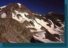
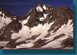
ridgeline where I was treated to a wonderful view of the Twin Crater Lakes
at the bottom of a very steep and rocky cliff. While I hiked to the ridgeline
from Carey Lake with relative ease, I do not think it is even possible
to hike down to the Twin Crater Lakes from the ridge, so steep is it. Two
figures were hanging out by the lakeside, and I could see their day-glo
orange tent set up in the same area as Andra and I had set up our tent
years ago. Lucky for them, there had been no lightening the evening before,
only lots of rain. After several painfully-cold minutes of enjoying the
view, I turned away and followed Frank and Makenzie down the slope, back
to the shore of Carey Lake, and further south to find the trail. Topping
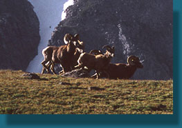
out on a low knoll, we came face to face with a herd of 5 bighorn sheep.
They watched us steadily for several minutes and nobody moved. I took a
few photographs, but I had my landscape lens on, and I knew they werent
likely to stick around while I pulled my pack off and swapped lenses. They
ran off gracefully over the high point east of Island Lake, and were gone.
We took the trail back to camp, and arrived there around 9:30, famished.
Andra had been away for most of the time we were gone, and had packed up
almost everything. I immediately downed a cliff bar, then a bag of granola
and dried milk while she folded clothes that were now well dry from hanging
in the sun. By 10:30, we were on the trail heading down. The hike down
is never as fun as the hike up, for obvious reasons, not the least of which
is the knowledge that one must often work the next day. Always a letdown
after a weekend in the woods. We passed lots of people hiking up on our
way down. So many, in fact, that I felt compelled to start keeping count
after awhile. By the time we reached the car, I had counted 43 hikers on
their way up, most of them part of large groups of 5 or more. At one point
we passed a boy scout troop with 12 people. Im not sure why so many were
hiking up on a Sunday, but I was glad that we were hiking out. By the time
we were back near parking elevation at 3:00, the air was hot and dry, and
our feet were aching. We all welcomed getting in the car, relaxing a bit,
and heading for home.
|
|


;)
;)
;)
;)
;)
;)
;)
;)
;)
;)
;)
;)
;)
;)
;)
;)
;)