Location:
Lost
River Range, Idaho
Maps: USGS 7.5'
Borah
Peak, Elkhorn Creek
Access: From
Challis, Idaho drive south on US 93 35 miles to Bench Springs Rd (there'll
be a sign for Borah Peak) where you'll turn east. Follow the graded dirt
road to its terminus at a small campground. Two wheel drive is OK.
Fees: None
Trail: Punishing
-- 5100 ft in 3.5 miles; gravelly in places, requiring scrambling in
others. Bring gloves to combat the sharp rock.
Dog Regulations:
None
- but very steep and not recommended for dogs.
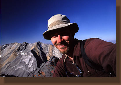
July 23, 2005
While working on temporary assignment in
Dubois, Idaho for the month of July, I decided to strike west one weekend
and explore central Idaho. A coworker had told tales about Borah Peak and
it sounded exciting, so I borrowed her Idaho Gazeteer and set off early
Friday afternoon for the Lost River Range. Naturally I made no other preparations
whatsoever. It was cloudy for most of the drive, yet very dry. I passed
through the small and decaying town of Arco and then followed the Big Lost
River northwest to a small campground at the trailhead of Borah Peak. When
I arrived there were others present, so I took the last remaining tent
site. There was no fee. The spots were placed uncomfortably close together,
but since it was not long to dark, this didnt bother me much. I took a
short walk up the trail, and read about the route: 3.5 miles with a 5100
ft elevation gain that takes you up to the highest point in Idaho at 12,
662 ft. I did not cook a dinner, but rather snacked on granola and fruit
before getting an early bedtime still before sundown. I expected to get
up around 5:30 to start the 3.5-mile hike. Through a very warm night,
I tossed and turned, until finally at 4:30 a bird of some sort starting
squawking loud enough to rouse me out of my unhappy sleep. I lay in the
dark, listening to the bird, and decided to go ahead a get started. I dressed
in the dark, loaded some cool water from my cooler and set out. As I neared
the trailhead, I was surprised to see that over 20 additional vehicles
had arrived after I had gone to bed the night before. These latecomers,
having no available campsites to retire to, had set up tents in the gravel
parking lot. Many were up and about, but I think most were still asleep
when I hit the trail. The moon was near full, providing ample light for
the trek. It was strangely warm and still, and I was soon down to my tshirt,
sweating and panting my way up the incredibly steep trail. In the dark,
I passed through the shadowy woods, hearing only the crunch of gravel underfoot
and the rythmic breathing from my mouth. In the half-light of dawn, I passed
a woman on her way down from the top, or rather very near the top at the
snow bridge. We chatted a little bit. Apparently she had spent a very cold
night up by the snow bridge, and only started coming down when she was
too cold to bear staying there any longer. I soon crossed paths with several
others in the dim light, all on their way down, Many had hiked up
under the full moon, and were only now descending. In places the trail
was very graveled and loose, and my foot twice slipped out from under
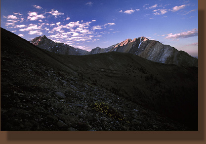
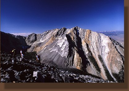
me as I took a step forward. Just at sunrise, I emerged above treeline.
The tips of peaks to the south of Borah gleamed with orange light. I quickened
my pace up the rocky tundra to better witness this wonderful red light
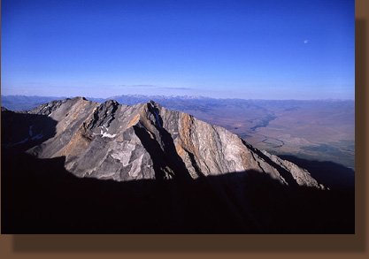
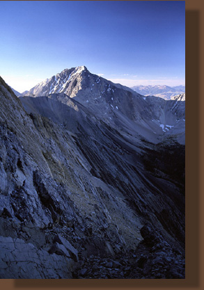
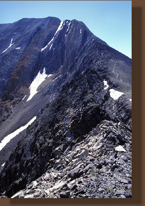
of dawn. The summit of Borah Peak lay plainly before me, well overhead.
I could clearly see the route as it led up and then take a left turn over
a snow bridge to follow a knife-ridge to the top. The sight of the snowbridge
made me very nervous, as a slip in that spot would result in unimpeded
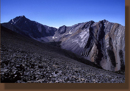
free sliding for a thousand feet. The trail led matter-of-factly uphill
through a rock field, and only leveled out for a brief period, where someone
had built a rock wall for a wind shelter. I hiked on, up the steep grade
over loose rock that led into solid rock, rough and sharp. The wind picked
up and though it had been warm below, in the windy shadow of Borah Peak,
I grew quite cold. The route was very difficult to find, and I am not at
all sure that I went the right way. My path led slowly up a nerve-wracking
pitch that dropped off in either direction several hundred feet into tallus
that sloped menacingly away for a thousand feet. I gripped the rock firmly
and inched my way up the sharp edge of rock. I leveled out after 25-30
feet in a protected cove between two rock walls, beyond each of which lay
a sharp dropoff. I spent 10 minutes trying to get up over the wall to the
ridge beyond, but could find no easy way to do this. I sat for a bit, nervous
about my precarious position, and finally started up a smooth rock with
minute toeholds. Halfway up, I uttered to myself, "What the hell are you
doing here?" I slid myself back down the rock, and finally conscious of
the fact that I was having absolutely no fun, I slowly picked my way down
the steep rock face 30 feet to flat ground. I have long known that adrenaline
is not what Im after in the woods. I dont want to make it to the summit
of Borah Peak if it requires my shitting my pants with fright to do it.
I am fairly convinced now that I somehow took a wrong turn finding the
route up. There must have been a less demanding route up. I conclude that
the wind and the shadow hid this from me. I am not too discouraged by this
because the hike, even without the summit, is fantastic. Once above treeline,
you can drink in the views the rest of the day from wherever you are. I
hiked down the trail some distance and then stopped in the first sunlight
patch to have a snack and some water. While seated, enjoying my refreshments
and the unimpeded view of the rock chasm to my left, several men came hiking
down the hill with a German wirehaired pointer. I watched them in the area
I had turned back at, and they seemed to have no trouble walking down from
there, rather than climbing, as they would have most certainly found unavoidable
had they taken the route I had attempted. This first led me to believe
I had taken a wrong turn. By that point, however, I was content to go no
further uphill. I sat in the sun and watched them come down, as well as
the first group of many who were on their way up. Once the bulk of the
20-carloads of folks had passed me, I started down. I dont know how many
people made it up to the summit. I caught up with a fellow my age who was
picking his way slowly back down on a sprained ankle. We talked along the
way for 5 minutes or so, and since he showed no signs of allowing me to
pass on the narrow trail, I pulled off to stop for breakfast of granola
and powdered milk (delicious). Back on the trail, I descended quickly,
and ended up catching up with the fellow with the sprained ankle again.
Assuring me he was doing just fine, I passed him and kept on going down.
The parking lot was full of cars, but no people. I suppose almost everyone
was up on the mountain somewhere. I packed up my camp gear and left the
place around 12:00. As I drove away, I was tempted to turn around and come
back, set up camp again and make a new try the next morning. Then I decided
there were far too many unexplored places to go see and there is so little
time in which to do it. I kept my car heading north towards Challis, towards
woods Id never seen before.
More
information on the Borah Peak route |
|