 |
 |
|
|
|
| Location: Turtle
Rock, in the Vedauwoo area of Medicine Bow National Forest east of Laramie
Maps: USGS quads Sherman Mt East & Sherman Mt West;Interactive topo Trail: Easy 2.7-mile loop around Turle Rock with lots of opportunities for off-trail rockhopping. The length of the trail varies depending on where you park. I usually park at the guard shack for winter hiking, making the loop 4.1 miles, but if you park at one of the trailheads, it's 2.7 miles. Trailhead: NAD83 z13 468447e 4556695n Elev: 8200' Access: From Laramie, WY, drive east on I-80 to the Vedauwoo exit, then take Vedauwoo Rd east (north of I-80) about a mile to the entrance to the Vedauwoo Recreation Area. You can park here for free, or continue on into the Area and pay a fee. The TH is not far from this point, and you cannot proceed farther than the entrance kiosk in winter, so this is a good place to park. Fees: If you drive in the recreation area, there is a fee. If you park just outside the entrance, there is no fee. This changed around 2011 when the forest service put up signs that say even if you park beyond the entrance kisok, you must still pay. I find this ridiculous, and simply park on the road just outside the parking lot at the kiosk. Dogs: Voice control Webcam:Vedauwoo Exit cam (.5 miles south) Weather:Current conditions Local Forecast |
| February 2004
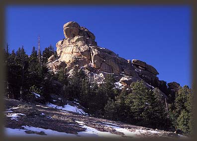
Turtle Rock lies just off Interstate 80 between Cheyenne and Laramie, Wyoming. A network of roads and picnic grounds snake through the area, assuring me that this place is well-used in the summer months. In January, however, when I first visited, only a few other cars decorated the snowed-over entrance road as I started my hike. The road off the main road was not plowed, so Frank, Makenzie (members of the vaunted Canis genus) and I hiked over giant snowdrifts intermixed with stretches of smooth blacktop as we followed the road towards the trailheads. Frank and Makenzie bounded through the snow, and frolicked in the sugary white powder. It didnt seem to sink in that if they strayed too far from the beaten path, they immediately fell up to their necks in snow. The day was clear and very cold. A typical Wyoming wind blew from the west at around 30 knots, inducing me to cover up almost every square inch of skin. Once again, my canine companions did not seem to notice that the wind chill factor was well below zero. Not knowing where I was headed, I wandered around in the snow a little, taking clues from footprints that had fallen ahead of mine, judging the main route by the density of boot and ski tracks. Of course, the majority could all have been going the wrong way, but thats a chance I took. I reached a point in front of a giant monolithic rock dome that had a sign planted on it indicating trailhead proximity. I assumed the advertised Turtle Rock was before me, and I spent a few moments trying to see the Turtle in the rock, on top of the rock or as the rock, whatever the case actually happens to be. No luck. Lots of interesting rocks around, but I never saw anything that struck me as turtle-like. Lots of rocks struck me as turd-like, but maybe thats just because Ive been hanging around my dogs in city parks with strictly-enforced poop-scooper laws for too long. At the insistence of my impatient companions, I headed downhill through some spruces following the beaten path of boot tracks. The path led to a small parking lot with an outhouse at one end and the trailhead at the other. I hit the trail and began walking west with the rock dome on my right. A thick aspen grove decorated this part of the trail, the tree trunks gleaming white in the white winter sun. Just past the aspen, the trail broke out into the open near a particularly fancy formation of rosey pink granite, stretching up like a watchtower against a gleaming blue sky. The rocks to the right beckoned, and I slogged through piled snow to get to the granite. My boots gripped the rock excellently, and all three of us rolled up the rockface, over boulders and skipping over deep snow drifts where possible, plowing through them when it was not. We reached a spot not too far up where the dogs could not navigate further. I am sure I could have pulled myself over the rocks ahead, but not with a dog under my arm, so we turned back and resumed the trail. Beaver ponds, frozen over with only a few small willows poking through the ice, appeared on my left. I threw rocks out onto the ice for Makenzie to chase, and laughed as she swirled and spun on the ice trying to catch the rocks. I had a hard time keeping Frank in sight. He kept trotting ahead quickly and disappearing around bends in the trail. As the area was heavily wooded, I constantly lost track of him as he took his white and black pelt into perfect camouflage under the dappled shadow and snow-covered forest floor. As anticipated, the trail began to resemble a loop, as it turned north and then veered to the northeast. I stopped to grab my ziploc of Texas pecans, sent to me by Dad and Grandparents as a special Christmas delicacy, and stowed my parka while I was at it. In the trees, the wind was less fierce, and my quick pace was beginning to activate the old sweat glands. Knowing that a damp shirt would be a liability in the wind-swept rocks to come, I tried anything to stay dry. The snow was deepest on the northwestern side of Turtle Rock, and I noted that fewer footprints had made it this far. In places, there were no footprints, and only the keen sniffer of Makenzie kept us near the trail. On the north side of the rock, I stopped to photograph the interesting rocks that came into view. The sun shined on me from the east, and warmed me up nicely. I had to constantly throw objects for the dogs behind me to keep them from running up the very hillside I was setting up for. They seem to believe that any photograph I make should have them in it. Vain little brutes, no doubt. After snapping a few clicks of the rocks, I decided to scramble up towards them for a better look. A long, rough slab of snow-free rock provided a quick highway up to the heights, and I made it up in no time. But as I neared the top, I was stymied by deep snow in crevices and unscalable rocks. It got dicey, and I endeavored no more elevation gain. From the position I attained, however, I could see quite a lot. The Sherman Mountains stretched to my north, and I could make out the plains around Cheyenne far on the eastern horizon. The tallest sections of Turtle Rock blocked my view to the south or west. I wandered around looking for a new place to descend, but because of the deep snow in areas, I decided it was best to return the way I had come. I regained the trail and continued on. I stopped for a water break under an arch created by two free-standing boulders on a sloping rock face. I threw rocks for Makenzie to chase (her favorite game) while Frank nosed around the underbrush looking for lunch. We scrambled among the rocks a little. I managed to hide from them both and watched with amusement as they circled around below me, frantically searching for a scent. Frank, who uses his eyes much more than Makenzie, saw me up above and made a few leaps to gain my perch. Makenzie soon followed. Very soon afterwards, the trail intersected one of the myriad tributaries of Crow Creek, and a pleasant little waterfall. Fifty feet beyond that lay another trailhead. From there I followed a road that led to another picnic area, and from there uphill towards the car. On later hikes I learned that the trail continues to the south of the trailhead all the way to the campground, spitting one out at camp #6. I met the first people
Id seen all day on the road, two guys with two dogs. Makenzie and Frank,
still far too concerned with the surrounding terrain, paid them almost
no heed as they ran right past with only a cursory sniff. Sometimes I wonder
if they are really dogs. I returned to the car after the short hike,
and lamented that the weather was not fair enough for a multiple-day trek.
Day hiking usually seems to be wanting the adventure of a backpacking trip.
I went home and began perusing Canyonlands maps, eager for spring
.
Nov 13, 2007
Returning to the saddle, I hiked south and got around to the south side of the mountain, where I picked my way down a boulder-laden canyon towards the loop trail below. I got cliffed out in the canyon, but cutting over to the next canyon east, I found smooht sailing all the way to the loop trail, which I followed clockwise around Turtle Rock, and back to the car.
|
;)
;)
;)
;)
;)
;)
;)
;)
;) ;)
;)
;)
;)
;)
;) |

Page Created March 31, 2004
Updated Oct 30, 2011
;)
;)