 |
|
|
| Location:
Popo Agie Wildneress, Shoshone National Forest, Wind River Range, Wyoming
Trail: Moderately strenuous, 8.7 miles, elevation gain 1700' Maps: USGS 7.5' quads: Cony Mt, Sweetwater Gap Fees: None Access: From Lander, take Sinks Canyon Rd west 13 miles to the end of pavement, where it becomes Louis Lake Road (FR 300). After 2 miles, turn right onto FR 302 towards the Fremont County Youth Camp. Go 4.5 miles to the end of FR302 and park. Trailhead: NAD83 z12 669401e 4729582n Elevation: 8850' Dogs: Leash control Webcam: 10 miles south at South Pass Weather: Current Conditions Local Forecast
Sunday, August 27, 2006 I spent the evening before packing up all my camping gear so I could get an early start in the morning, and by 7:00 I was parked in Larry's driveway helping him load his gear in the trunk. The day was warm and sunny as we drove northwest on Highway 287 to Lander, Wyoming where we had lunch at 11:30 at a place called the Gannet Grill. We were back on the road by 12:30, and after a stop for gas, were on our way up the Sinks Canyon Road. It's called Sinks Canyon because the Popo Agie River goes subterranean for ¼ mile. You can visit the spot where the river flows underground, and then go visit where it bubbles out of the rock downstream. Fishing is prohibited at the resurface point, and there are trout two feet long in the deep pool below the wooden observation deck. Beyond the sink, we encountered a ripped-up road on the switchbacks that lead up to Worthen Meadow Reservoir, the municipal water source for Lander which does not show up on my topographic map. A major widening project was underway, perhaps in preparation for paving operations, and we waited about 10 minutes before someone came along to fix the broken signal that gave us a green light. It was a weekend, so they weren't working on it. We got past that and drove on to the lake. We parked the car in a virtually empty lot by the lake (8,840ft), and cinched down the straps on our overnight packs before setting off up the newly-fashioned trail at 2:00. For the first ¼ mile the trail is new, then it joins the old trail near Roaring Fork Lake just past the wilderness boundary. The Popo Agie wilderness was created in 1984 by the Wyoming Wilderness Act. The outlet from the lake was low, so we had no problem crossing it. The air was warm and uncommonly still. The first colors of fall were touching the aspen and choke cherry along the creek. The rock-laden trail wound west through a lodgepole pine forest with an exceedingly dry duff understory. Very little green vegetation grew in the shade of endless ranks of pine boles. We walked on, comfortably, and soon crossed a creek where Andra and I had camped several years ago. We hadn't made it very far that day but had instead spent over an hour wading in Roaring Fork Creek just downstream from the lake. That was our dog Makenzie's first swimming experience (one that obviously went well since she splashes into water whenever she finds it). Shortly past the stream, we reached the meadow, which has a 100-yard long boardwalk across it, presumably to allow passage through what must be a marsh in the early summer. At this time of year, the ground was fairly dry and quite firm. After the meadow we hiked up a long series of switchbacks that occasionally offered glimpses to Worthen Meadow Reservoir down below, but for the most part ran through limber pine forest. Stopping for a break, I watched a squirrel chew through a pine cone peduncle that then dropped to the ground. The squirrel raced down the tree trunk, retrieved the cone, and ran off with it to another tree. These were pretty plump squirrels, so I'd guess the pine nuts are good winter food. At 4:00 we topped out at around 10,550 feet on the northern end of Roaring Fork Mountain. Ahead of us, Wind River Peak rose up imposingly with intimidating jagged crags and frightening steepness to the highest point within the 101,000 acre Popo Agie Wilderness. We had not seen any hikers since Roaring Fork Lake, but there were 4 horses tethered to trees on the far side of the pass. No humans. The horses watched us quietly as we walked by. The sky was cloudy, but it was not raining yet, and I was thankful that we were able to hike this late in the day without the nuisance of thunderstorms. The trail descended a series of switchbacks on the west side of the mountain down to 10,100 ft to the intersection with the Stough Basin trail. By this time it was 5:30, and we were both pretty tired from the long uphill hike. Also, eating a greasy burger and fries is not the best way to start a long backpacking trip. We stopped and had snacks by Stough Creek, and the remaining 1 mile hike to the south to the first of the Stough Creek Lakes took us close to an hour to cover. By 6:30, we were on a hill to the west of the first major lake, which sits at 10,484. I found the precise spot Andra and I had pitched our tent, briefly, 4 years before. On that trip, we left pretty quickly due to unbeatable swarms of biting flies and mosquitoes. Remembering that, I took a moment to revel in the absolute bug-free air of late August. There are about 40 separate bodies of water in Stough Creek Basin, of which about a dozen are large enough to expect respectably-sized fish to inhabit. Larry and I had both brought our fishing poles, and we were anxious to try our hand at the finicky mountain trout. But it was late, and the sun was lowering through the limber pines as I pitched my tent in the thick shelter of several pine trees, making sure I was not in a natural depression where water might puddle. Larry set his tent up about 30 yards away. We cooked a dinner of chicken-flavored rice, then went to bed just as it was getting too dark to walk around without a flashlight. I read A Bend in the River, a story about a man trying to run a business in a fictional country that resembles the Congo in every way, in my cozy tent for about 30 minutes. In Africa people are wondering what they will eat today, and I am wondering if the sun will be shining brightly in the morning so I can take good photos of the lakes. A whole different world. During the night, it rained hard for several hours, and I was glad I had thought about the tent site in terms of water puddling. Except for the very tip of my sleeping bag, which touched the end of the tent, I stayed dry.
Monday, August 28 The next morning I woke briefly several times and noticed it was light out, but I could tell the sun was not up yet, so I stayed in the tent until 8:30. It was cold out, and everything was soaked. Its often amazing to me just how much heat a tiny little tent can hold in, and how effective the 0.5-mm nylon walls are at keeping water out. A dusting of snow covered Roaring Fork Mountain, which is an odd mountain shaped like a U with the open end pointing north. Stough Creek Basin lies inside the U, so at all times, one is looking at Roaring Fork Mountain no matter which direction one looks. The sunlight gleamed brightly off the snow, contrasting brilliantly with the glowing blue sky. In a short time, the sun cleared the eastern mountain rim, and slanted rays of warm yellow light flooded through camp. In no time, all the logs and rocks were steaming. I pulled my sleeping bag out to find the end damp, and placed it in the sun to dry for a little while. Larry stirred shortly after, and we had breakfast bars before packing up day packs an zipping up tents to leave. By 9:30 we were on our way under partly cloudy skies, fishing gear in hand. There are a few faint trails in the basin and we followed one south for a little while past another lake (none of the lakes in the basin are named a tribute to the remoteness of the place), but since the basin is mostly not forested, navigation by sight is fairly straightforward. We split away from the trail and headed southwest, uphill, and topped out on a nice round knob at 10,900 ft. From this bald-rock vantage point, we could look directly east to the two largest lakes, or directly west to the two prettiest lakes, both nestled at the base of dramatic 800-foot cliffs. We decided to head west to the two smaller lakes. The lower and larger of the two lakes lies at about 10,560 ft, and we fished the south end of this lake for a couple of hours with great success. The water of the lower lake was deep and clear, and large rocks on the south end of the lake allowed a great vantage point from which I could watch the fish, pick the one I wanted to catch, then cast the fly just for him (or her). I just love being able to watch the whole process, from the fly landing gently on the water, to the fish seeing it, speeding for it, opening it's mouth and snagging it before diving down. After catching several fish, I hiked uphill a hundred feet to the next lake, smaller than the first and with calmer water. I fished here for a bit, saw some fish, but none that were willing to take a chance on a #16 black gnat. One disadvantage of such clear water is that fish can see you too. The only fish biting were brook trout, but all told I caught 6 with my fly rod, and Larry caught 12 with his spinner. Spinner wins. Since we had several days to camp yet, neither of us kept any of them. We whiled away a couple of hours in this fashion before noting ominous gray clouds closing in from the east. We started back to camp, but made it only about 300 yards before the rain began. We both donned our rainpants and jacket, and kept on, through increasingly stern sheets of rain. Clouds piled in to block out the sun. The cold water froze the hand with which I held my fly rod, and I had to keep switching hands. We hiked east to try to intercept the trail that would lead back to camp. We found it, and followed it north into a thick pine grove to take shelter. Within the pines, no rain came though to us, and we could pull down our hoods and watch the rain pelt the surface of the lake. It continued to rain hard, and the sky continued to cloud up. Deciding that things were not likely to improve much, we continued on north. Then the hail came, only pea sized, but in mass. The ground was soon white, and my measly rainjacket hood was no protection from stinging pelts on my ears from the little white ice rocks. We trudged down the trail, streaming with water, and made it back to camp. The hail abated, but the rain continued. We both retreated to our tents, and I napped and read the afternoon away under steady rain. I hate being stuck in the tent, but at least I was dry, or more accurately, at least I was only somewhat damp. The rain stopped by 5:00, and I emerged from my tent with a stiff back, cold. The sun came out for a brief time before it sank below the hills, but was not out long enough to dry anything well. We spent a good amount of time trying to start a fire, which of course was made difficult by the 5-hour rain we just had. By searching the lee side of large trees, I was able to find dry kindling, and with the help of a paper towel, we finally got a small blaze going. It wasnt easy, though. Adding dry wood from the lee side of trees until it was hot, we got a respectable blaze going that was then capable of handling damp wood. Typically in this situation I would have sprinkled some white gas from my stove on the kindling and thrown in a match for an instant blaze, but I had left my stove at home and we couldn't figure out a way to "sprinkle" butane from Larry's stove onto the wood. We did try, however. It doesn't work. Years of fire restrictions in the national forests of the west have made fire starters so unnecessary that they have vanished from my typical overnight gear. Once the fire was going nicely, we made dinner and sat around the fire until well after dark. Few things are as enjoyable as a fire in the woods at night. The sky cleared, and stars twinkled overhead. I don't think we finally went to bed until close to 11:00. I went back to my tent and read my book for awhile, and jotted some notes down on the day's events.
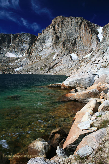
Tuesday, August 29 We were up at 7:00 and eating a breakfast of granola and instant milk. The sun was blazing, and I sat in the warmth while I ate. We packed our day packs and hiked south on the trail past the biggest lake and on to the next. The day was clear and bright, so we had confidence to go explore up high. We followed a drainage uphill to the west to one of the highest lakes in Stough Basin at around 10, 950 feet. This lake is shaped like a drumstick with the narrow end pointing north, and is surrounded on three sides by massive, steep cliffs rising up over 800 feet. We approached this lake from the northeast, and had to descend through a boulder field to reach the edge of the water. The lake was still and quiet, with the clearest water I've seen in any lake. No green was visible in this bowl of rock, and it seemed very sterile. Larry and I both cast out fishing lines, but nothing happened. If there are fish in this lake, they are very reclusive. It seems more likely that no fish live here. Nevertheless, the lake is extraordinary, and we spent a good amount of time checking it out. We exited to the southeast, up a steep section of boulders where no dog could ever go, and then contoured around to the south so that we overlooked a large lake to the south. From this vantage point at 11,300 feet, we could see almost all of Stough Basin, unimpeded. For 4 years I had lamented that I did not have the chance to fully explore Stough Basin on my last trip here, and I was glad that I was finally able to get a feel for this wonderful place. The wind had really picked up by this point, and we skittered down a steep south-facing slope to the water's edge at 10,900 feet and had lunch in the warm sun. Dramatic cliffs to the west of this lake framed it beautifully, and the water had a strange turquoise color to it. Despite the wind that was creating whitecaps on the lake, we tried fishing anyway. No action at all. In less than an hour we were hiking downhill to the east. The wind mellowed as we hiked lower, and we stopped at a couple of small lakes at around 10,700 feet to fish. Here I caught a 2 brown trout and a brook trout, two of which I kept. Larry had no luck with his spinner at these tarns. Fly wins. We continued on downstream to the big lake on the east side of the basin at 10,500 feet, and fished there. While there were many fish cruising the water's edge, they were very finicky, and more often than not, would investigate the fly, but turn and swim off. I tried every fly I had, and only managed to hook one. It was the largest fish I caught on the trip, a 14" cutthroat. I took him home with me. Larry had no luck at this lake with his spinner, and headed off to explore other lakes. Fly wins again. Primed by the catch of my big trout, I continued to fish the lake for an hour with no results. I hiked west and fished some in the big lake in that direction, but it was shallow, and the wind had increased to the point of making long casts virtually impossible. The clouds had also built up, and I began to hike back to camp. I stopped at every lake I passed to fish a little, but never caught anything. While passing along the trail near camp, I saw a man seated by the wood's edge, reading. I don't think he saw me. I arrived back in camp around 4:00. Larry was not around, so I took a nap and read some more. When I emerged close to 6:00, Larry was back and reading his book near the firepit. We decided to go try more fishing, now that the wind had mellowed a little, at the lake we were camped next to. I walked around to the north and west sides of the lake, and he fished on the west side. I caught 2 brook trout, keeping both, and he caught 4 large cutthroat trout in a very short time. Spinner wins this time. Thus, by dinnertime, we had 8 fish between us in a plastic bag anchored underwater in the lake. We made another fire, with less difficulty this time, and made dinner of macaroni and cheese while staying up enjoying the warm fire until 10:00. The night was dry, but starting at midnight, the wind howled so loudly it woke me up repeatedly in alarm. I envisioned little tornadoes spinning madly in tight, evil little spirals, starting in the west, then passing overhead in a roar and retreating to the east. At every pass, I could hear a rain of pine needles fall on the tent. This went on for hours, and made for a fitful night of sleep.
Wednesday, August 30 The following morning we were both up just at dawn. The sun came up bright and unimpeded by clouds, and it was still windy. We had a quick breakfast of granola and dried milk. On the drive in we had seen a sign on the Louis Lake Road that advised of a daily weekday road closure from 10AM to 4PM. We knew we would not be able to make it back to the car and down past the construction before 10, so we planned on not getting to that point until 4:00. Thus, we packed our daypacks and headed back to the southwest and the lake where we had found the fish so willing to bite artificial lures. On the way, we fished the lake near camp, and Larry caught another 2 cutthroat trout. I caught nothing. Spinner wins. We didn't have too many more fish to catch before we limited out, since we now had 10 between us. We took a different route to the lake than before, and came at it from the north. The wind was relentless, and fly fishing proved very difficult. The fish were deep in the water, and didn't show themselves. Larry went up to the next lake and fished there for awhile, caught a brook trout, but let it go. When he came back, he quickly caught a brook trout on the north shore near where I fished. I scooted down lower to the water, and found a relatively calm spot to cast in. The fish were reluctant to rise, but I saw a glimmer of a fish as I was pulling my fly in, so I cast back to that same spot, and caught him. Fly ties spinner for keepers. That made 12, and we divided up the fish between us to max our limits. At that point, we hiked back to camp and ate lunch. I then walked away from camp a short ways and began cleaning the fish. Within about 30 seconds, the first fly had appeared. Within 10 minutes, the air was buzzing with hundreds of black flies, swarming around me. I had to work quickly to keep them off the fish. Im sure by the end of the day, all signs that fish were cleaned on that rock had been erased. We packed up our gear, slowly and with care, as we were in no real hurry. The hike back to the car was a long haul, as is usual for the hike out. We passed by a third spot I had camped at with Andra, and I thought again how much nicer a trip is when you're not swarmed with bugs. We were sprinkled on a little as we hiked over Roaring Fork Mountain, and I feared the dark clouds to the west would materialize into vicious thunderstorms that would overtake us before we reached the car, but that didn't happen. We reached the car around 4:00, and cruised down the dirt road to the construction, where we had to wait 20 minutes for a pilot car to lead us down. In Lander, we stopped and had dinner on the roof of Tony's pizza, then put the pedal to the metal to I-80, and home to Cheyenne long after dark.
|
;)
|
|
|
|
|
|
Page Created November 4, 2006 Comments |
;)
;)
;)
;)
;)
;)
;)
;)
;)
;)
;)
;)
;)
;)
;)
;)
;)
;)
;)
;)
;)
;)
