
| Location: Natural Bridges National Monument,
Utah; west of Blanding, Utah
Maps: USGS 1:24,000 Moss Back Butte, Kane Gulch Trail: Start at Kachina Bridge overlook, hike overland to Sipapu Bridge, then down White Canyon back to Kachina and the car. Distance=5.6 miles. Most of the trail is fairly flat and mellow, but the descent into White Canyon is steep, as well as the ascent back out. Access: From Blanding, take Hwy 95 west to the junction with Hwy 261, and continue for about 1.5 miles on Hwy 95 to the turnoff for Hwy 275, which leads right into the park. Pavement, all the way. Fees: $6 for a 7-day pass |
| May 30, 2007
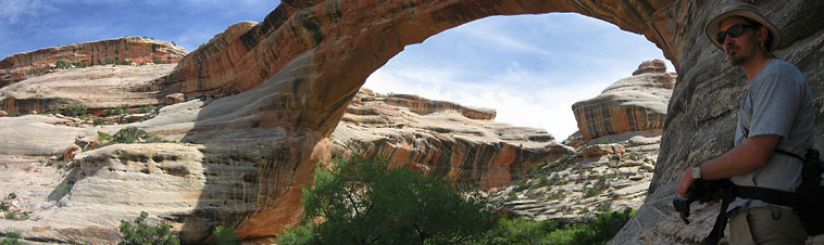
After two full days exploring Moqui Canyon, Dave and I were ready to take the show to a different venue, and since Natural Bridges National Monument was nearby, we stopped in on a sunny morning in early May to check things out. I had never read or seen anything about this isolated park, so it was nice to come to it without any expectations. A nice woman at the visitor center pointed out the trail possibilities, and we opted for the mid-sized model of a 2-bridge loop starting at Kachina Bridge, hiking over the mesa to Sipapu Bridge, then downcanyon back to Kachina Bridge, where the car would be waiting at the top of the canyon rim. This is roughly a 5.6-mile loop. After filling our empty water jugs at the pump out front, we drove down the 9-mile one-way park loop to the first of several pullouts. Eager to see the advertised destinations and move our legs once again, we exited the car and hiked downhill over the flat rocks to the edge of White Canyon, from where we could see Sipapu Bridge below. Enormous. The white rocks of the canyon were stained with black streaks of oxides, and reminded me of the canyons in Dinosaur National Monument. Verdant green oak trees blazed against the white rock, and the glimmer of the tiny stream in the bottom of White Canyon sparkled in the morning sunlight far below. We drove on, and in haste to start hiking, skipped the remaining pullouts until we came to the parking area for Kachina Bridge. I slathered my skin with Hawaiin Tropics sunblock (made in Florida), and loaded my backpack with water and food, most of which I would neither eat or drink. Another car pulled into the pullout just as we crossed the pavement and headed away from the bridge and up into the pinyon juniper of the mesa. The trail was very well defined as it snaked its way through an ocean of black cryptobiotic crust and gnarled junipers. An occasional trail-side pinyon offered shade and a water break, but mostly it was exposed and pretty warm. A sheen of sweat sprung up on my forehead and mixed with the Hawaiin Tropic sunscreen, which advertises that it wont sweat off, but makes no claims that you wont wipe it off as you wipe sweat from your brown. The sky was blue, yet already at 10AM, puffy white clouds loomed on the horizon, threatening to morph from little cute and furry to mean and ugly. We reached the Sipapu parking lot in about an hour, where we found many people standing around checking things out in the canyon below. We walked past them and began to descend the slope into the canyon. I overheard one older man comment on the urge to hike down and get close to the bridge, "Maybe 20 years ago I could have, but not now". With this disappointing admission of defeat behind us, Dave and I headed down. I considered that one day I too would be too old and frail to do the likes of this trail, but for now my body can handle it and so I went with pleasure. Large rocks marked the path across the slickrock, and then we walked down a long iron staircase that swayed back and forth to get to the next level below. A wooden ladder followed, as did more steps (Chutes and Ladders comes to mind). We reached a long slab of rock that led out to the edge of the main channel and from there took in perhaps the best view of Sipapu Bridge. I setup a timed portrait of us, but chickenshit Dave insisted he not get closer than 2 feet from the 300-foot cliff edge so the picture is a little off-kilter and I am chopped off the frame (jeez, Dave, you puss). From there, the trail winds down steeply, but is aided by quarried steps, steel handrails and another ladder. Down below we stopped in the shadow of the rock bridge and admired the immensity of the thing. Arches are formed from wind, whereas bridges are formed by flowing water (see your park brochure for more details). Bridges seem to be less abundant in the western US, although Ive not conducted serious scientific inquiry into this. Dave and I have both been to the worlds largest natural bridge, Rainbow Bridge, and here we encountered the second largest. The natural wonders checklist gets a workout. The path led further down into a cool and refreshing white oak thicket, where the leaves were freshly unfurled and still velvety soft. Two people left just as we arrived, and we were able to enjoy this special place in complete silence. We explored upcanyon a short ways and enjoyed the sunny-side view of the bridge. At the sound of approaching folks, we slipped into the willows that lined the creek and headed downcanyon. We had learned that Anasazi ruins were present at a particular point in the canyon wall not far from the bridge, but we never noticed them. No matter. The hike was enjoyable enough. We followed the twisting course of the trickle of water in White Canyon on a well-worn trail through the sandy canyon bottom. Flowers were blooming in profusion, and in the heat, the occasional shade offered by imposing junipers was ever more welcome. We passed by the mouth of Deer Canyon, barely visible beyond the screen of willows, and although we had been warned where to look, we also walked right past Horse Collar Ruins. Easy to miss. Probably built that way on purpose. Soon, Kachina Bridge came into view, and we found a shady spot under a rock ledge to the east of it from which to admire this natural wonder. Kachina is much wider than Sipapu, and its opening much smaller. Folks who get paid to study such things say this is the youngest of the 3 major bridges in the park, while Sipapu is the oldest. The coolness under the wide bridge was soothing, and it was difficult to leave it for the anticipated hike up the steep canyon wall to the car above. Nevertheless, we followed the sandy trail under the blazing sun down the canyon, then up the rock face of White Canyon on quarried steps to the canyon rim. A hot hike, but short and manageable. I would definitely be wary of trying this one in July. Note: There are no ladders or metal stairs on this end of the hike. Back at the car, we loaded our gear and resumed our drive down the road. We stopped at the overlook for the third arch, Owachomo, but lacked the energy to hike down to it. Also, the puffy white clouds to the east had conspired to form a boiling black thunderhead that would make any hiker wary. So, we bade goodbye to Natural Bridges National Monument and capped it off with a nice treat at the Shake Shack in Monticello on our way north to Moab. Theres just no hiking hurt a good Oreo shake cant soothe.
|
;)
;)
;)
;)
;)
;)
;)
;)
;)
;)
;)
;)
;)
;)
;)
;) |
|
Comments |
;)
;)
;)
;)
;)