| Location:Ruby
Mountain Wilderness in the Ruby Mountains, south of Elko, Nevada
Access: From I-80 at Elko, NV, take Exit 303 and head west on Business I-80 through Elko. (Theres a Starbucks in the Red Lion Casino if you need it after your long drive). Turn left (southeast) on 5th St, which becomes Hwy 227. Head southeast on Hwy 227 through Spring Creek and Lamoille for 18 miles and turn south on Lamoille Canyon Rd (660). Head south 12.2 miles through Lamoille Canyon to the end of the road and park. Maps: USGS Ruby Dome quad; USFS map Ruby Mts and East Humboldt Wildernesses, available from any Humboldt National Forest office Trailhead: UTM NAD83 zone 11 637334e 4496098n 8800' Trail: The trails are well-signed and maintained throughout, though steep in many places. The route described below does not stick to trails the entire time. A trip to Lake and Wines Peak via Liberty Pass is a 17.8 mile round-trip with about 5700 ft elevation gain. Dogs: This area would be great for dogs. I can't recall what the dog regulations are, but I saw many canine hikers while I was there. Fees: None Weather: National Weather Service Forecast Snow Info from LMON2 Station near the trailhead Snow map centered on Favre Lake (put in the right date) July 31, 2009
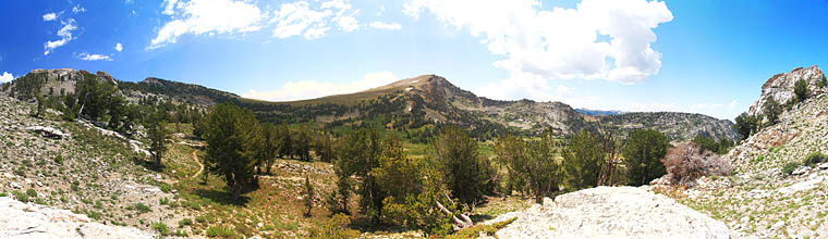
I headed downhill through lush grass, flowers and sparse limber pines towards Favre Lake. I took the turnoff for the lake, and noticed a few horses grazing in the meadow above the lake. A few guys had their tent set up not far from the Favre Lake outlet. I passed by with a wave and hiked east along the south shore of the lake, passing by another tent with no occupant around. I kept an eye out for a trail up to Castle Lake, but I didnt see one, so as I neared the eastern edge of Favre Lake, I simply turned south and headed up the steep, heavily-wooded slope to Castle Lake. Castle Lake is a bit smaller than Favre Lake, but it definitely seems much shallower. There is no part of the lake you cant see the bottom of if you stand higher up on the surrounding cliffs. The lake sits in a great-looking cirque with barren rock walls, topped by Lake Peak on the east side. The summit of Lake Peak is not visible from the lake, but it is if you hike up just a bit on the western side of the lake to get some elevation. I poked around the wooded northern shore and found a great spot about 50 yards from the lake amongst a thick grove of very large limber pine to set up my tent. I tried to set it up so that it would be shaded most of the afternoon, and thereby stay cool in case I wanted to nap after tomorrow mornings hike. Fire rings in the area attested to the use of this lake by campers, maybe hunters. I unpacked my gear, hung my food and ventured down to the lake to dip some water into my canvas bucket. I hauled that back to camp and washed my face, arms and chest. Very refreshing. Then I grabbed my book and settled back to rest for awhile. I hadnt been in camp more than an hour, relaxing against a nice, sloping pine trunk, when a small buck came walking right between me and the tent, seemingly oblivious of me, though I know that cant be. He walked slowly through, and disappeared in the thick willows near the lake. I noted with great pleasure that there were no mosquitoes about at all. Not one. Very unusual. After sitting and reading for a bit, afternoon drowsiness set in so I took a 1-hr siesta in the tent. After a delicious nap, I got up around 5:30 and walked around to the east side of the lake and higher up to the sound of running water. I found a nice little waterfall with cold, clear water to filter. The lake water probably would be just as fine, but it was quite a bit warmer than the small stream. As I approached the water and the wet, boggy ground around the stream, the mosquitoes came out to feed, so there are at least some of those little buggers around. Nothing worse than being bitten all over but having both hands occupied so you cant swat them away. I filtered water as quickly as I could and hightailed it back to the dryer areas around camp where there were no bugs. I anticipated thunderstorms in the afternoon, but the sky stayed clear. I had originally planned on trying to climb Lake Peak from this side of the mountain, but after examining the craggy ridge leading to it from the north, and the steep, scree-covered slope on the west side, I decided Id better hike around and try it from the south, where the slope didnt look quite so steep on the topo map. It was 7:00 by then, which was too late to start such a hike. Instead, I hiked up the western side of the cirque to a ridge that overlooked the pass between Favre and Furlong Lakes. It was a steep climb up an open slope with just a few trees scattered about, but the walk was worth it. From the ridge, the mountains to the west were visible, including Ruby Dome. An interesting arch in a rock fin jutting out from the ridge I stood on framed the sunset nicely. I puttered around along the ridgeline until after sunset, noting the fresh mountain goat droppings but seeing no goats. I sat near the arch in the still, quiet air of evening and watched surrounding peaks for half an hour or so, scanning for the white fleecy coats of those elusive mountain goats, but I didnt see any. As dark descended, I scampered back down the slope to the tent, arriving in almost complete darkness around 8:45. Bats flitted about amongst the pines. I grabbed my headlamp and washed my socks and shirt in the water bucket, hanging them on a line strung between two nearby trees. I slid into the small tent and read my book for a bit before feeling cool enough to fall asleep. August 1, 2009
I left the summit at 8:50 and headed south along the forested ridgeline towards the Wines Peak Saddle. As the terrain flattened out between Lake and Wines Peaks, the trees ended and I walked through an open tundra of low-growing grasses, lupines and cushion forbs. This plain descended gradually to the west, but dropped off precipitously to the east. It was from this direction that I heard a clattering of soft hooves on rock and some clattering stones dropping away. I looked over to see 2 large mountain goats nimbly leaping up the near-vertical face of the drop to the plain behind me, and on up into the trees towards Lake Peak. I snapped a few photographs, but I had my short lens on and I was facing the sun to see them, so they are hardly wall-mounting material. I was, nevertheless, pleased to see a mountain goat for the first time. At the lowest part of the saddle, I took a break and sat at the overhang of the drop. I took off my socks to dry them and removed my new super-duper insoles because the arch support was giving my foot a blister. Moving on, I headed right towards Wines Peak, and in the process caught a trail heading in the same direction. The slope was minor, so the trail was easy going all the way up. I climbed a point to the east of the trail, but when I got there I could see it wasnt the true summit. So, I headed west to the highpoint and reached it at 10:15. Lots of flies here, too, for some reason. I only noticed them on the summits. It was getting very warm, and large cumulous clouds were floating in. Just as I was leaving the summit, 2 guys showed up from the south where they had been hiking the Ruby Crest Trail. They were out of water and anxious to find some. I offered them some of mine, but when they learned that ? Creek and ? Lake were just down the trail, they said they could wait. I left them at the summit and headed on down that way to ? Creek. The trail slid down the grassy tundra into the forest, and I veered off the trail to find a spot to eat lunch at 11:15. I found a shady, grassy spot under an enormous limber pine, and ate a nice meal of crackers, tuna, chocolate and water. While I sat there, the two fellows I saw at Wines Peak summit passed by 200 yards away on the trail, not seeing me. A third guy followed behind them with a dog. Shortly after, I resumed the trail, and passed these three again at the creek where they were filtering water. I reached the pass over into the next drainage, and headed down a long trail, with what seemed like an unnecessary amount of switchbacks, to Farve Lake. At Favre Lake, I crossed the outlet stream and headed towards the lake and then up to Castle Lake. I reached camp at 1:15. Sweaty, salty and hot, I immediately stripped down and took a full-body bath in the canvas bucket (How to Take a Bath in One Gallon of Water, by Sam Cox), glancing around often to see if anyone was coming. This is a pretty remote spot, so I didnt expect any company. I dried off with a washcloth, and then got dressed in nice, dry, clean-smelling clothes. I then washed my salty clothes and hung them to dry. Big clouds rolled in, and I thought it would certainly rain, but it did not. I retrieved my book and sat against a wide log to read. Contrary to my estimation that I would see no other people up this way, three men dressed in camoflauge came stalking through quietly with bows. I didnt think it was hunting season yet, but maybe Nevada is different than Wyoming. I took a trip up to filter water, and ate some more tuna and crackers (Salt!). I finished my book, which was a bad thing, because I was too tired to attempt any more hikes even if the weather didnt look like imminent rain. I napped about 30 minutes to shake a minor headache, but that didnt work. I think I just lost too much salt on the hike. It sprinkled a bit around 7:00, and the wind blew in great gusts, but then it passed and left a hot, still evening. I really should have brought another book. I got in the tent around 8:00 and tried to fall asleep as quickly as possible. August 2, 2009
Instead of heading back the way Id come in, I went around the east side of Favre Lake, staying in the shade of the ridge and enjoying the riotous wildflowers on the steep slope. I eventually intersected the Favre Lake Trail, and followed that uphill to Liberty Lake, where 3 groups of backpackers had their tents pitched around the lake. Busy place. The sun was out in full, and the day was clear and warm. Very enjoyable. I sweated up the dusty trail to a nice perch above Liberty Lake, took a few parting photographs, and then turned north and slipped over Liberty Pass. I cruised downhill quickly, past Lamoille Lake, and into the thicker woods beyond, where I stopped opposite one of the shallow Dollar Lakes for a snack at around 9:45. It was a breezy morning, and in the shade where I sat, shirt soaked with sweat, kind of chilly. I kicked off my boots and let my socks dry a bit, and closed my eyes for a few minutes. When I opened them again, I was struck by how much green there was all around. Green grass, green lake water, green pines, green willows. So much green. I hopped back on the trail and ambled comfortably down, passing lots of hikers on their way up for a day at Lamoille Lake, until I reached the parking lot. I threw my pack in the car, changed shoes, and sucked down a Coke from the cooler that was still surprisingly cold. It was still early in the day, so I prepared my day pack for another hike, and thats a whole other trip report, friend.
|
;)
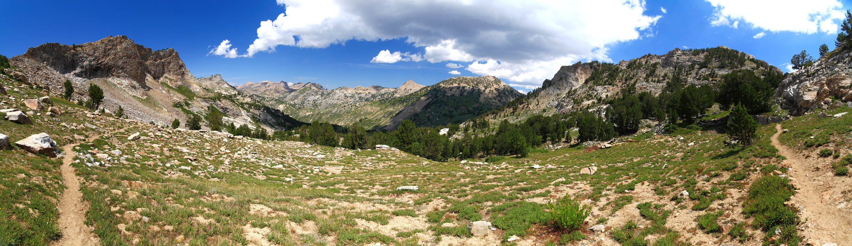
In the Dollar Lakes area up towards Liberty Pass
|
;)
;)
;)
;)
;)
;)
;)
;)
;)
;)
;)
;)
;)
;)
;)
;)
;)
;)
;)
;)
;)
;)
;)
;)
;)
;)
;)
;)
;)
;)
;)
;)
;)
;)
;)
;)
;)