North Fork Little Laramie River
Wyoming
Location: Medicine Bow National Forest, southwest of Laramie,
Wyoming
Access: From Laramie, take Hwy 130 west for 28 miles to Centennial,
then continue for another 3.8 miles, then turn north onto the Sand Lake
Rd, and go 2 miles to the parking area on the west side of the road, just
past the North Fork Campground.
Trailhead: 401588e 4579945n Elev: 9340'
Trail: Well-marked trail that follows the North Fork of the
Little Laramie through lush forest for 3 miles upstream, then branches
off through sparse lodgepole forest to the Brooklyn Lake Rd, which it reaches
in a little over 4 miles, making this an 8-mile roundtrip with a little
over 1000' elevation gain en route.
Maps: USGS 1:24,000 Centennial,
Morgan
Dogs: No posted regulations
Fees: None
Webcam: Arlington
Interchange, 30 miles north
Weather: Current
& Recent Conditions
Snow
conditions
NWS
Forecast |
 July
30, 2003 July
30, 2003
Long about 1820, a group of French-Canadian trappers were collecting
beaver pelts in the network of mountain streams that feed the North Platte
River in Wyoming and Northern Colorado. Jacques LaRamie, a member of this
group, set out one day to explore a tributary of the North Platte and never
returned. He was apparently at the very least a well-liked fellow, as the
tributary he explored was subsequently named the Laramie River. The Laramie
River has its origins high in the Laramie Mountains of northern Colorado
at Chambers Lake. It runs north into the Larmie Plains of Wyoming. There's
also a Little Laramie River that begins in the Snowy Range, with North,
Middle and South Forks, all of which come together and logically feed into
the Laramie River just north of the city of Laramie Wyoming, home of the
University of Wyoming, not to be confused with Fort Laramie, which lies
further north. The beautiful Laramie Mountains continue north from Colorado
into Wyoming and extend north of Cheyenne up to Casper just west of Interstate
25. The capital city of Cheyenne is in Laramie County, but oddly enough
the city of Laramie is in Albany County (and so is Saratoga). Across the
state border from Laramie County is Larimer County, which holds Fort Collins
and Loveland, Colorado. Both counties, naturally, name virtually all civic
projects Larimie or Larimer, respectively. Geologists have even termed
the upthrust of the Rocky Mountains "The Laramide Revolution". Only Presidents
have so many things named after them...and LaRamie was just a beaver trapper!
Thoughts of this sort, most not quite so profound, circled through my head
one fine July day in 2003 as I shouldered my pack and herded Frank onto
the trail. I was the lone car in the lot on Sand Lake Rd, so I had high
expectations for the trip. Frank also had high expectations from the trip,
but mostly due to the chirps and clutters from warm-blooded animals in
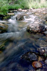
the woods. We were at this point to hike along a brisk stream named North
Fork Little Laramie River.
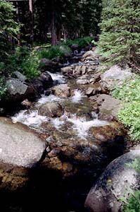
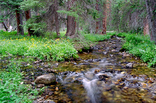
For the first couple of miles, the trail led through a fairly thick
forest of spruce, lodgepole pine and fir, crossing the North Fork at a
few places. Frank chased down and killed a chipmunk for the first time
in his life. He crunched its bones and swallowed it without a drop of blood
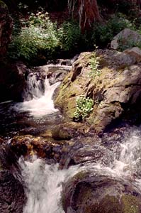
spilt. He seemed extremely pleased with himself. Several excellent photographic
opportunities presented themselves, and I dallied long trying to find the
perfect angle for the photogenic stream. I came across two forest service
employees installing a new foot bridge, talking loudly, the guy plainly
flirting with the girl to the point that my approach went completely unnoticed.
Only as I crossed the defunct bridge did they notice me.
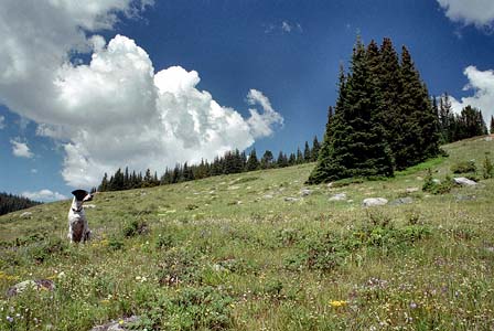
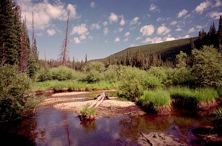
For a brief period, a wide meadow opened up to the right of the trail.
Quite in contrast from the rushing water downstream, this section of the
North Fork was lazy and meandering, slowly sweeping back and forth through
thick, squat willows. Away from the willows, alpine flower species bloomed
in moderate profusion. I had clearly missed the peak by just a bit. This
was the high point of the trail, and after that it descended towards Barber
Lake Rd. I followed the trail as it reentered trees, and before long my
stomach told me it was time for lunch. Retreating from the trail a comfortable
distance, I sat down in the shade of the pines and snacked on granola bars,
fruit and chocolate. Frank lay down in the sun just beyond the shade of
the tree. Never seen a dog that likes the sun so much. A large group of
hikers passed by, completely unaware of me. After they had passed, I continued
down the trail until it intersected Barber Lake Rd. At that point, I turned
around and walked back.
On the way back, I encountered more hikers walking opposite my direction,
some fishing in the small current of the North Fork. After topping out
in elevation, once again, at the meadows, I snuck off the trail once more
and climbed up the steep side of the stream to find a nice, hidden ledge
in the deep woods. I laid down in the soft pine needle bed, and dozed.
Frank dozed as well. I woke up chilled, and moved over next to Frank, who
had been napping in the sunshine all along. I dozed longer until shade
overtook my bed. A short hike can take all day if you find a good
napping spot.
After the nap there were no more long stops. I passed the folks I had
already seen at the meadows, and ended the hike shortly after back at the
car.
|