September 2003
Weve decided to hike Mt Chocorua. All the
guidebooks gush over it, noting that it is the most photographed mountain
in the White Mountains (a vague honor) and also noting that even 55-year
olds like my mother can make it without pause and without climbing ropes,
which is a plus for me too. My girlfriend Andra and I have been in the
great northeast for about a week, taking in various pleasures from the
Atlantic Ocean to the carnival-like atmosphere of the Saratoga Springs
Horserace. I am blessed to have fallen smitten over a woman who likes to
hike almost as much as I do, and yet is not so masculine that she could
out-wrestle me (I think). This is a rare find. My mother, who has lived
in the New Hampshire since 1995, is also enthusiastic about being out from
under shingled roofs and plastered ceilings when the weather outside is
nice. The dog that lives with her, a "stout" Cocker Spaniel named Yossel,
never passes up an opportunity to rove around. So, naturally, we decide
that hiking a good mountain trail is the thing to do, and Chocorua fits
the bill.
 The drive north from New Hampshires queen city,
Manchester, to the mountain town of Lincoln is pleasant. The day is warm,
the air is sweet and humid, and that peculiar blue which is somehow unique
to September glows electrically in the sky overhead, virtually unimpeded
by white clouds. It is still early for leaf-changing, being only Labor
Day, and green vegetation still dominates the slopes and undulating hills.
A quick stop at the Forest Service building in Lincoln scores us a $25
year-long pass that officially allows us to go enjoy our public lands.
I vote for the $3 daily pass, but Mom overrules, insisting shell be coming
back. I believe her, mainly because I would also be coming back again and
again if I lived in Manchester.
The drive north from New Hampshires queen city,
Manchester, to the mountain town of Lincoln is pleasant. The day is warm,
the air is sweet and humid, and that peculiar blue which is somehow unique
to September glows electrically in the sky overhead, virtually unimpeded
by white clouds. It is still early for leaf-changing, being only Labor
Day, and green vegetation still dominates the slopes and undulating hills.
A quick stop at the Forest Service building in Lincoln scores us a $25
year-long pass that officially allows us to go enjoy our public lands.
I vote for the $3 daily pass, but Mom overrules, insisting shell be coming
back. I believe her, mainly because I would also be coming back again and
again if I lived in Manchester.
We set out west on the Kancamagus Highway
(NH112), a name that engraves itself on the mind. I like the sound of the
name, enhanced as it is by all whom I speak with who seem to add an extra
n in the word. Kancamagus means "Fearless One", and was the name given
to the grandnephew of Passaconaway, a Chief who united 17 native tribes
of central New England into the Penacook Confederacy in 16271. Kancamagus
promoted peace between white settlers and natives, but in conflict escalated
between the English and natives, and he fled with many followers to northern
New Hampshire/Canada. The Kancamagus Highway stretches from the town of
Lincoln in the east to the town of Conway in the west. Begun in 1837, it
finally linked these two towns in 19592 (and you thought road crews were
slow in your neighborhood). The road is well-kept and dark black. We pass
a paving crew making it moreso on our way east under large maples, birches
and white pines. The road winds uphill through the deep woods generally
shadowing the Pemigewasset River towards Kancamagus Pass (2855), where
the road then descends by degrees along the Swift River towards Conway.
Chocorua is closer to Conway than to Lincoln, so we get to enjoy most of
the highway and surrounding beauty on the way.
It is mid-morning by the time we reach the
parking lot, and I am anxious to stretch my legs on the gravelly trail
leading into the dark woods. The parking lot at the trailhead is full,
so we park off the road as far as possible, entering the Volvo into a stomach-rising
tilt. We load a backpack with food and water, and leash Yossel before starting
out. It is wonderful to be here, in woods that are so foreign to the western
forests I know. The trail follows an old logging road for a short distance,
then branches off onto a steep, narrow for the rest of the way, and we
walk single file, talking a little, but mostly breathing hard as we quickly
rise up in elevation along the steep grade. In places, I grab onto birch
trunks lining the trail to pull myself up large boulders. This trail would
be tough in icy weather. The advertised length of the route we plan to
take is 3.8 miles, one-way. Looking at the map reveals a myriad of branch
trails and spur routes that could take one weeks to fully explore. In fact,
it seems quite possible from the map that one could visit the summit of
every major mountain in the area without ever leaving a trail. The interconnectedness
is starkly different from the forests of Colorado and Wyoming, but then
New Hampshire itself is starkly different too.
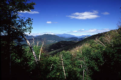
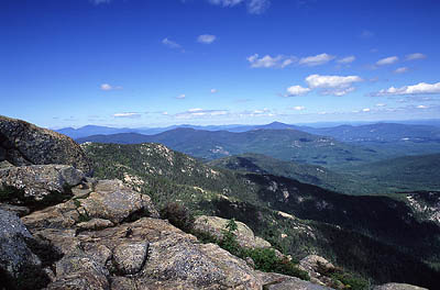
 As we rise up above the Swift River Valley, views
to the north tease through the trees. Large, green-velvet humps of mountains
loom on the horizon. More than halfway up, we take a spur loop trail to
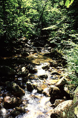
the east to see Champney and Pitcher Falls. At Champney Falls we stop only
briefly because there is a crowd of hikers wading in the water and hanging
out. We are greedy, and want this spot to ourselves for a few moments.
It is very nice to look at, and we decide to take this route on the way
down. The trail is very wet in this area, and Yossel picks up pounds of
mud on his shaggy legs. We rejoin the trail to the summit and rise up over
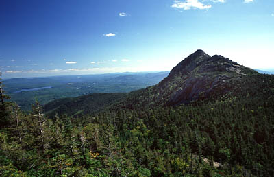
a ridge where the conical shape of Mt Chocorua comes into view. From
our vantage, the mountain is more of a shadow, backlit by the bright fall
sun sailing low on the southern horizon. We pick our way along the rocky
trail south and, by degrees, rise up above the trees and onto open slabs
of granite intermingled with short pines and spruce. It is calm and warm.
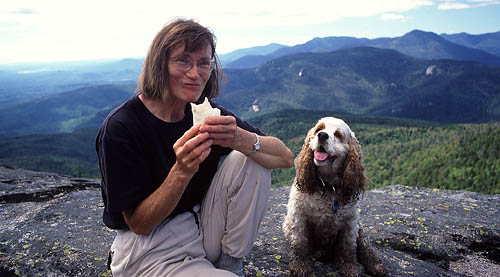
We stop for lunch on a quiet slab of rock on the eastern face near the
summit. Lunch consists of delicious peanut butter and jelly sandwiches,
sweet granola bars and apples. Moving upward, we encounter lots and lots
of fellow hikers, most of them staked out in a comfortable rock niche,
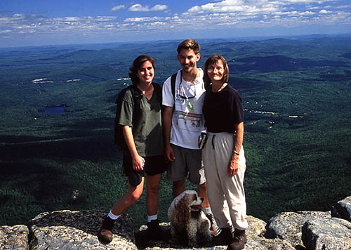
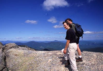
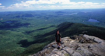
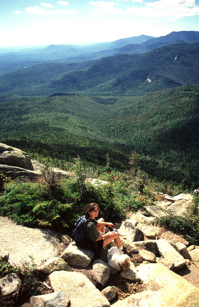
enjoying the panoramic views. We reach the very top, and mill around slowly,
looking at the mountains and forests surrounding this bald peak. Someone
makes sheep noises at Yossel, whose white shaggy coat and slick, muddy
black legs do indeed make him look sheepish.
As we rise up above the Swift River Valley, views
to the north tease through the trees. Large, green-velvet humps of mountains
loom on the horizon. More than halfway up, we take a spur loop trail to
the east to see Champney and Pitcher Falls. At Champney Falls we stop only
briefly because there is a crowd of hikers wading in the water and hanging
out. We are greedy, and want this spot to ourselves for a few moments.
It is very nice to look at, and we decide to take this route on the way
down. The trail is very wet in this area, and Yossel picks up pounds of
mud on his shaggy legs. We rejoin the trail to the summit and rise up over
a ridge where the conical shape of Mt Chocorua comes into view. From
our vantage, the mountain is more of a shadow, backlit by the bright fall
sun sailing low on the southern horizon. We pick our way along the rocky
trail south and, by degrees, rise up above the trees and onto open slabs
of granite intermingled with short pines and spruce. It is calm and warm.
We stop for lunch on a quiet slab of rock on the eastern face near the
summit. Lunch consists of delicious peanut butter and jelly sandwiches,
sweet granola bars and apples. Moving upward, we encounter lots and lots
of fellow hikers, most of them staked out in a comfortable rock niche,
enjoying the panoramic views. We reach the very top, and mill around slowly,
looking at the mountains and forests surrounding this bald peak. Someone
makes sheep noises at Yossel, whose white shaggy coat and slick, muddy
black legs do indeed make him look sheepish.
 After half an hour up on top, we start down and
decide to take a quick side trip to the summit of Middle Sister Mt. There
are virtually no people on Middle Sister, and it is quiet. We stop again
on here to sip water and relax in the warm autumn sunshine. Yossel looks
tired, and sways as he sits with his eyes drooping. It appears as if he
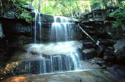
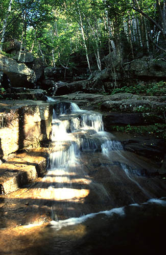
will fall over if allowed to relax too long. On our way down we take the
short side trail to Champney Falls and it is empty. We sit next to the
running, splashing falls and enjoy the glitter of afternoon sunlight sparkling
on the water. Im told that springtime brings impressive volume to the
falls, but the dainty cascade we witness is also nice.
After half an hour up on top, we start down and
decide to take a quick side trip to the summit of Middle Sister Mt. There
are virtually no people on Middle Sister, and it is quiet. We stop again
on here to sip water and relax in the warm autumn sunshine. Yossel looks
tired, and sways as he sits with his eyes drooping. It appears as if he
will fall over if allowed to relax too long. On our way down we take the
short side trail to Champney Falls and it is empty. We sit next to the
running, splashing falls and enjoy the glitter of afternoon sunlight sparkling
on the water. Im told that springtime brings impressive volume to the
falls, but the dainty cascade we witness is also nice.
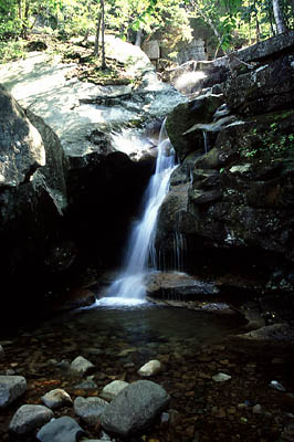
 The rest of the trip was spent plodding downhill
through the woods to the car. A quick stop off in Sabbaday Falls rounded
out the day. We had dinner at a restaurant in Lincoln where I ate lobster
for the first and last time of my life. (Yuck!)
The rest of the trip was spent plodding downhill
through the woods to the car. A quick stop off in Sabbaday Falls rounded
out the day. We had dinner at a restaurant in Lincoln where I ate lobster
for the first and last time of my life. (Yuck!)
1www.dickshovel.com/penna.html
2 www.yankeecruisah.com/kanc.html |

 |