Location: Cape Lookout
State Park on the Oregon Coast, near Tillamook
Access: From Netarts, drive 7.8
miles south on Netarts Bay Rd to the trailhead on the west which is clearly
marked. From the south, a few miles north of Beaver, take the "Three Capes
Loop" (Sand Lake Rd) to the west for about 8 miles to the trailhead.
Trail: Easy, well-trod 2.5-mile
one-way trip along the mellow ridgeline to a lookout near the tip of the
peninsula. Often muddy and cool.
Maps: USGS 7.5' Quadrangle: Sand
Lake
Fees: None, unless camping in the
park
September, 2005
It was day 3 of our
great 2005 Pacific Northwest getaway. Andra and I cruised up Hwy 101 with
the nonchalance only tourists are capable of. I scanned the Oregon gazetteer
as Andra drove north, and engaged in an unending conversation regarding
where to stop, and when to keep going, knowing that we could not possibly
stop at all the roadside attractions along the way to Washington. I love
that so much of the Oregon coast is easily accessible and not fenced off
by rich folks.
From the map, a jutting
finger of land poking out like a thumb from the continent caught my eye,
and it looked like just the sort of place we needed to be. After leaving
Highway 101, we followed the winding roads through forests and fields until
we arrived at the parking lot for the Cape Lookout trail at around 10AM.
The sun was shining without hindrance, just as I like it. The parking lot
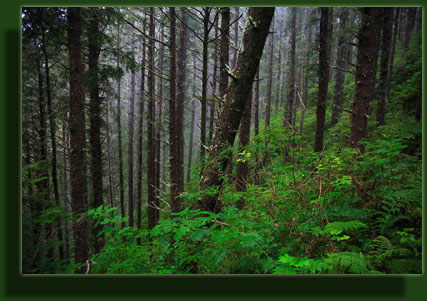
was cool and quiet in the shade of massive spruce and fir trees. Only 2
cars were in the lot. Their occupants were not to be seen. We packed up
some refreshments into my daypack and I grabbed my camera and we were off
down the trail.
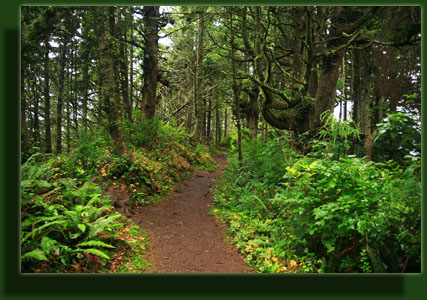
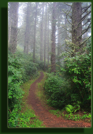
Shaded densely, the
narrow path was soft and spongy like a 3 foot layer of pressed sawdust.
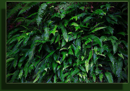
Ferns covered the ground on both sides of the trail, while giant spruces
created the feeling of being inside a building rather than outdoors. The
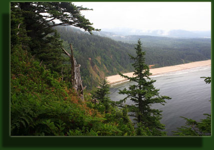
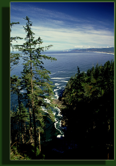
air was calm and thick with maritime moisture. The trail led west, with
the land sloping away steeply to the south, into the ocean. So far down
was the water that the waves could be seen, but not heard. Within 50 yards
of the trailhead, the trail branched, with one fork leading downward, presumably
to the water, and the other fork staying level and heading west. We headed
west.
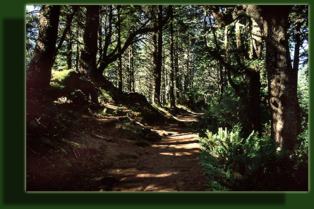
The smell of the forest
is perhaps one of the most exciting smells I know of. The smell of the
forest is the smell of fun, if you ask me. Rich aromas of shaded tree bark
and mouldering evergreen needles filled the air. Flecks of sunlight littered
the ground of wet soil and rotting leaves as we walked quickly in the cool
morning air. High banks of sword ferns lined the trail, while graceful
maidenhair ferns clung to the north faces of rocky banks and downed logs.
Moss covered almost everything that wasn't already photosynthesizing. The
trail stayed pretty level, only dipping down as it crossed ravines, then
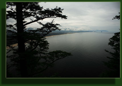
returning to the same elevation. It was quite easy walking. The ocean was
in view to the south for the first half of the trek, then the trail meandered
over to the north side of the peninsula and the ocean was again in view
to the north, only now we could hear the crashing of the waves and enjoy
the foam and surf on the volcanic rock shore below. To the north, we could
see the chain of sea stacks off of Cape Meares. From the best vantage
point of this action, a chain-link fence lined the trail to prevent overzealous
watchers from plunging down the Cliffside 200 feet to the water below.
We passed several groups
of people, seemingly more than was warranted by the low number of cars
in the lot. Their voices did not travel far in the thick growth, and we
heard them little more than a few seconds before seeing them, and then
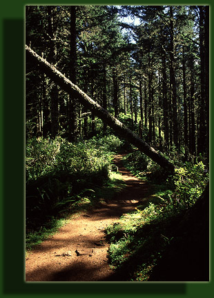
they were gone. I stopped often to take photographs in the golden forest
light, the liquid ditty floating on microscopic water droplets wafting
through the air beneath the spruces. Continuing on the trail brought us
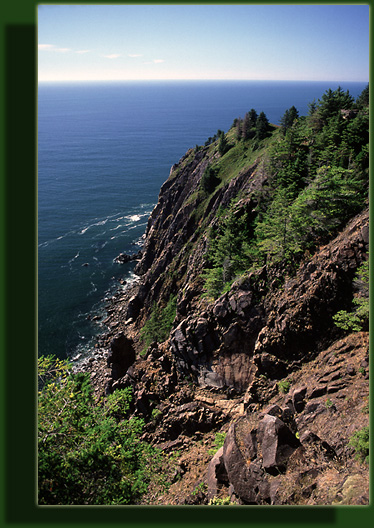
back around to the southern-face, and here and there the trail darted out
of the trees and into the bright sunlight. In these areas the cliffs were
so steep that trees could not grow, and metal rails held trekkers on the
trail. We had not initially intended to hike the entire peninsula, but
we were so enjoying ourselves that we found ourselves out at the end of
the trail before long. A park bench situated in the gravel clearing provided
a nice spot for a lunch of peanut butter and jelly sandwiches, and an inquisitive
squirrel provided entertainment in excess of the tremendous views out to
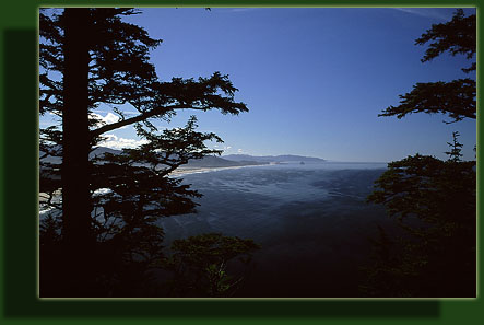
sea we had from this cliff-top vantage point. Looking back east, the main
coast looked so far away it was as if we had boarded a giant ship that
was just heaving to. Below us, the ocean currents could be discerned by
the change in water color, and the giant dark blue arcs swept out to the
horizon as if ships had passed by and we were watching their wakes. The
peninsula did not in fact end at this point, but the designers of the trail
did not construct any convenient path to go further. Behind the park bench,
thick shrubs barred easy passage, and a fence bounded the other half of
the clearing on the cliffside. We sat enjoying ourselves for 20 minutes
until we heard approaching voices, and decided it was too small a place
to pack too many people, and began walking back.
The walk back seemed
to take longer than the walk in, perhaps because it was not nearly so amazing
to see the trail a second time. Many more people were on the trail, and
I wondered how popular this place would be in the summer. In an hour and
a half, give or take, we were back at the car.
|
|