Location:
Bear Lake area of Rocky Mt National Park
Maps: USGS 1:24,000-scale
Longs
Peak and McHenrys Peak or
Trails Illustrated 1:59,000-scale Rocky Mt National Park (#200)
Trail: Several options
exist. Primary access is from Bierstadt Trailhead which leads up a fairly
steep slope to the lake in 1.2 miles. From the lake, take the flat, 1-mile
loop around the lake before heading back down. Allow 2 hours round-trip.
Trailhead: NAD83 zone
13 447000e 4463526n Elevation: 8865'
Access: From Interstate
25, take Highway 34 through Loveland and Estes Park to the Beaver Meadows
entrance. Just beyond the entrance gate, turn south on Bear Lake Rd and
drive 6.5 miles to the Bierstadt Lake trailhead, or in summer, take a free
shuttle from the shuttle lot 5 miles up Bear Lake Rd.
Fees (2008): $20 7-day
park pass; $35 annual park pass; $80 annual Federal public lands pass
Dogs: not allowed
on trails
Webcam: Estes
Park, 6 miles to the northeast
Weather: Current
and recent conditions Local
Forecast
March 12, 2007
On a beautiful and sunny
Monday morning, Andra and I ate lunch at the quiet and largely-deserted
picnic ground at Sprague Lake where we were watched closely by a blue jay.
Just up the road, we started hiking up the Bierstadt Lake trail at around
noon, enjoying the sudden solitude a Monday morning brings after a busy
weekend. We were the only car in the lot, and the only hikers on the trail
as far as I could tell. The snow was very deep in places, but the sun was
shining warmly, and we were soon sweating in the sun, down to our shortsleeves.
Some of the trail was clear of ice, and only muddy, but most of the trail
was still ice-packed where the snow had been trampled to solid ice over
the last winter. Ironically, all the surrounding snow was gone, and only
the trail remained icy. We walked carefully, but occasionally a foot would
plunge through the rotten snow a couple of feet, and come up with snow
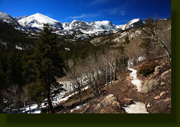
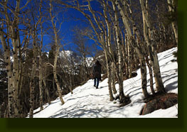
in the sock. For the first 30 minutes, the trail switchbacked up a south-facing
slope with a few aspen, but with plenty of open area for enjoying the snow-laden
mountains just to the west. We stopped in the shade of the few ponderosa
pines to cool off. I even got a sunburn (thats when you know winter is
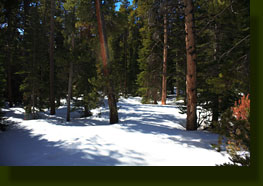
finally over). The trail entered the spruce forest at the top of the hill,
and flattened out as it intersected the loop trail around Bierstadt Lake.
We took the left fork of a snow-packed trail through the trees but saw
no lake. I kept my eye out for it, and it was only when we were more than
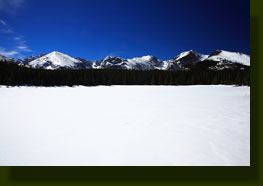
halfway around the lake that a sidetrail opened up to the lake. We followed
it for 50 meters or so and it emptied out on the shore of frozen, snow-covered
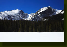
Bierstadt Lake. To the south, the rugged mountains rose up into the blue
sky. The first people we saw the entire hike, a group of 4 older folks,
were lunching on the lakeshore. The snow was brilliant white, and was painful
to look at or near for long. A couple of Clarks nutcrackers immediately
came over to see if we had food, and they remained with us the entire time
we were at the lake. We sat and enjoyed the extremely warm air and bright
sunlight for about 30 minutes before continuing on the loop around the
lake. The trail was not well traveled for the remainder of the loop, and
at some point we found ourselves back on the lake itself for a brief time.
The nutcrackers noted us and came to check us out again. We followed footprints
in the snow right back to where we had started the loop, and then retraced
our steps back downhill, completing the hike in about 2 hours. |
 |
;)
;)
;)
;)
;)